
Abtwil AG
| AG is the abbreviation for the canton of Aargau in Switzerland and is used to avoid confusion with other entries of the name Abtwil . |
| Abtwil | |
|---|---|
 |
|
| State : |
|
| Canton : |
|
| District : | Muri |
| BFS no. : | 4221 |
| Postal code : | 5646 |
| Coordinates : | 669 448 / 225 244 |
| Height : | 536 m above sea level M. |
| Height range : | 500–664 m above sea level M. |
| Area : | 4.14 km² |
| Residents: | 966 (December 31, 2019) |
| Population density : | 233 inhabitants per km² |
|
Proportion of foreigners : (residents without citizenship ) |
12.7% (December 31, 2019) |
| Website: | www.abtwilag.ch |
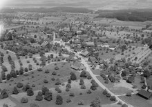
 Abtwil village center |
|
| Location of the municipality | |
  |
|
Abtwil (in local dialect : [ ˈɑpˑəl ]) is a municipality in the Swiss canton of Aargau . It belongs to the Muri district and lies on the border with the canton of Lucerne .
geography
The community lies at the foot of the southernmost foothills of the Lindenberg , at the transition between the Reuss valley in the east and the Seetal in the west. About two hundred meters south of the actual village is the hamlet of Old Chile, somewhat offset. Most of the municipality is flat to undulating. Only in the northwest does the terrain rise slightly to the ridge of the Lindenberg. In the far south extends the moss, a small moor area .
The area of the municipality is 414 hectares , 91 hectares of which are forested and 36 hectares are built over. The highest point is on the ridge of the Lindenberg at 665 m above sea level. M. , the deepest on the eastern municipality boundary at 500 m above sea level. M. Neighboring communities are Sins in the north and east and Hohenrain in the west.
history
The area around Abtwil was already settled during Roman times. At that time there was a villa rustica on the "Heidenhügel" . The Roman ruin around the Hauten Alamannen two dozen graves in the sand stone floor . The graves discovered during construction in 1860 had been carved into the ground to size. This technique has also been used on graves in Algeria attributed to immigrant Berbers . It has not yet been proven whether it was more than coincidence.
The first mention of the village ( et in Apwil VI liberos censarios ) from the first half of the twelfth century is only preserved in a copy from the 14th century; the oldest original document from 1256 ( in Apwiler ) comes from the Muri monastery . At that time, Count Gottfried von Habsburg-Laufenburg tried in vain to assert his claim to ownership of the village. The place name probably goes back to an Old High German composition * App (in) wilari and means «Hofsiedlung des Appo».
In the Middle Ages, Abtwil belonged to the Habsburg office of Meienberg . In 1415, Lucerne conquered the Meienberg office, but in 1425 had to return it to the common property of the Confederates . The free offices were formed from the conquered areas , a common rule . After the old church above the Alemannic cemetery (not yet discovered at the time) in the Old Chile district was demolished in 1742 and replaced by a new building at the current location, Abtwil became its own parish in 1748. Until 1865 the pastors all came from Engelberg Monastery . Until 1805, the manor was in the hands of the Johanniterkommende in Hohenrain .
In March 1798 the French took Switzerland and proclaimed the Helvetic Republic . Abtwil was now a municipality in the Muri district of the short-lived Canton of Baden ; since 1803 it has belonged to the canton of Aargau. The village remained dominated by agriculture well into the 20th century, with the number of inhabitants fluctuating between 300 and 400 for many decades. During the Second World War , peat was extracted from the moss . At the end of the 1980s , significant construction activity began, favored by the proximity to the cities of Lucerne and Zug . The congregation nearly doubled in fifteen years.
Attractions


The baroque parish church of St. Germanus was built from 1740 to 1742 and replaced an older church building that can be traced back to the 14th century. In 1877, the church tower was built at the front of the choir , the furnishings mostly come from the 19th century and are in the classical style.
coat of arms
The blazon of the municipal coat of arms reads: "In blue the yellow curvature of an abbot's staff with a waving white velum (sweat cloth) on a yellow pendant and with yellow tassels." The coat of arms, introduced in 1953, shows the emblem of St. Germanus von Granfelden , the first abbot of Moutier-Grandval and patron of the church of Abtwil.
population
The population developed as follows:
| year | 1850 | 1900 | 1930 | 1950 | 1960 | 1970 | 1980 | 1990 | 2000 | 2010 |
| Residents | 393 | 325 | 347 | 342 | 343 | 297 | 321 | 369 | 674 | 907 |
On December 31, 2019, 966 people lived in Abtwil, the proportion of foreigners was 12.7%. In the 2015 census, 60.0% described themselves as Roman Catholic and 12.6% as Reformed ; 27.4% were non-denominational or of other faiths. 97.0% said German as their main language in the 2000 census .
Politics and law
The assembly of those entitled to vote, the municipal assembly , exercises legislative power. The executing authority is the five-member municipal council . He is elected by the people in the majority procedure, his term of office is four years. The parish council leads and represents the parish. To this end, it implements the resolutions of the municipal assembly and the tasks assigned to it by the canton. The District Court of Muri is primarily responsible for legal disputes . Abtwil belongs to the Friedensrichterkreis XIII (Muri).
economy
According to the corporate structure statistics (STATENT) collected in 2015, Abtwil has around 190 jobs, 25% of them in agriculture, 35% in industry and 40% in the service sector. Far more than half of the workforce are commuters and the majority work in the agglomerations of Lucerne and Zug .
traffic
The community is a bit away from through traffic, but is connected to Sins , Hochdorf and Ballwil via well-developed side roads . A bus tour run by the Seetal-Freiamt bus company (part of the Zugerland Verkehrsbetriebe since 2004 ) runs from Sins via Auw , Abtwil and Fenkrieden back to Sins.
education
The community has a kindergarten and a primary school . All upper levels of the compulsory elementary school ( Realschule , Secondary School , District School ) can be attended in Sins . The closest grammar school is the Cantonal School in Wohlen .
Personalities
- Joseph Balmer (1828–1918), church and history painter
- Josef Villiger (1910–1992), dialect author who grew up in Abtwil
- Harry Knüsel (* 1961) wrestling king
literature
- Anton Wohler: Abtwil (AG). In: Historical Lexicon of Switzerland .
- Georg Germann : The art monuments of the canton Aargau . Ed .: Society for Swiss Art History . Volume V: The Muri District. Birkhäuser Verlag, Basel 1967, DNB 457321970 .
Web links
Individual evidence
- ↑ Cantonal population statistics 2019. Department of Finance and Resources, Statistics Aargau, March 30, 2020, accessed on April 2, 2019 .
- ↑ Cantonal population statistics 2019. Department of Finance and Resources, Statistics Aargau, March 30, 2020, accessed on April 2, 2019 .
- ↑ a b Beat Zehnder: The community names of the canton of Aargau . Historical sources and linguistic interpretations. In: Historical Society of the Canton of Aargau (Ed.): Argovia . Annual journal of the Historical Society of the Canton of Aargau. tape 100 / II . Verlag Sauerländer, Aarau 1991, ISBN 3-7941-3122-3 , p. 58-59 . Specified phonetic transcription : áp̄əl .
- ^ National map of Switzerland, sheet 1130, Swisstopo.
- ↑ Standard area statistics - municipalities according to 4 main areas. Federal Statistical Office , November 26, 2018, accessed on May 10, 2019 .
- ^ Germann: The art monuments of the Canton of Aargau, Volume V: District of Muri. Pp. 5-12.
- ^ Joseph Galliker, Marcel Giger: Municipal coat of arms of the Canton of Aargau . Lehrmittelverlag des Kantons Aargau, book 2004, ISBN 3-906738-07-8 , p. 102 .
- ↑ Population development in the municipalities of the Canton of Aargau since 1850. (Excel) In: Eidg. Volkszählung 2000. Statistics Aargau, 2001, archived from the original on October 8, 2018 ; accessed on May 8, 2019 .
- ↑ Resident population by religious affiliation, 2015. (Excel) In: Population and Households, Community Tables 2015. Statistics Aargau, accessed on May 10, 2019 .
- ↑ Swiss Federal Census 2000: Economic resident population by main language as well as by districts and municipalities. (Excel) Statistics Aargau, archived from the original on August 10, 2018 ; accessed on May 8, 2019 .
- ↑ circles of justice of the peace. Canton of Aargau, accessed on June 20, 2019 .
- ↑ Statistics of the corporate structure (STATENT). (Excel, 157 kB) Statistics Aargau, 2016, accessed on May 8, 2019 .
Abtwil | Aristau | Auw | Beinwil (Freiamt) | Besenbüren | Bettwil | Boswil | Coins | Buttwil | Dietwil | Geltwil | Kallern | Merenschwand | Mühlau | Muri | Oberrüti | Rottenschwil | Sins | Waltenschwil
Former municipality: Benzenschwil | Forest houses | Will
Canton of Aargau | Districts of the Canton of Aargau | Municipalities in the Canton of Aargau