
Mühlau AG
| AG is the abbreviation for the canton of Aargau in Switzerland and is used to avoid confusion with other entries of the name Mühlau . |
| Mühlau | |
|---|---|
 |
|
| State : |
|
| Canton : |
|
| District : | Muri |
| BFS no. : | 4235 |
| Postal code : | 5642 |
| Coordinates : | 671 993 / 231423 |
| Height : | 397 m above sea level M. |
| Height range : | 385–481 m above sea level M. |
| Area : | 5.52 km² |
| Residents: | 1205 (December 31, 2019) |
| Population density : | 218 inhabitants per km² |
|
Proportion of foreigners : (residents without citizenship ) |
19.0% (December 31, 2019) |
| Website: | www.muehlau.ch |
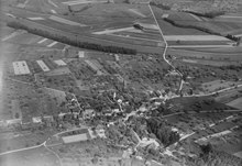
 View from the east |
|
| Location of the municipality | |
  |
|
Mühlau ( Swiss German : ˈmylɑʊ ) is a municipality in the Swiss canton of Aargau . It belongs to the Muri district and lies on the Reuss , which forms the border with the canton of Zug .
geography
The community consists of several districts. The main settlement of Mühlau is around half a kilometer from the banks of the Reuss on the easternmost foothills of the Lindenberg on the alluvial cone of the Sembach . To the south of it, on a slightly elevated terrace, lies the district of Krähenbühl ( 460 m above sea level ), which has merged with Mühlau in recent decades. One kilometer to the north-northeast is the hamlet of Schoren ( 389 m above sea level ), one kilometer to the north-north-west of the hamlet of Kestenberg ( 415 m above sea level ).
The Reuss level is only about 200 meters wide in the southernmost part of the municipality, but widens near the village of Mühlau and reaches a width of almost two kilometers at the northern municipality border. An artificial canal runs along the river at a distance of 20 to 400 meters and drains the plain, while the river bed is bordered by flood protection dams. East of Schoren, on the river bank of the Schachen , is a large swamp area with ponds and moats. A total of 33 hectares are under nature protection .
The area of the municipality is 552 hectares , of which 74 hectares are forested and 69 hectares are built over. The highest point is at 475 m above sea level. M. in the Fellenweid, the deepest at 387 m above sea level. M. on the Reuss. Neighboring communities are Merenschwand in the north, Hünenberg in the east, Sins in the south, Auw in the southwest and Beinwil (Freiamt) in the west.
history
In the Himmelreich area between Mühlau and Kestenberg there was an estate during Roman times . However, some of the remains were used to build the new church in the 1860s. In addition, some bells, coins, ceramic fragments and a statuette of a rooster came to light. Mulnowe was first mentioned in a document in 1274. The place name is derived from the Old High German Mulinouwa and means “land near the water mill”. Kestenberg was first mentioned in 1328 as Kestiberg , Schoren in 1371 as Schorren .
In the Middle Ages the lords of ruled Hünenberg about Mühlau and practiced both the lower as well as the high jurisdiction of. After the Battle of Sempach in 1386, when the Hünenbergers fought on the side of the defeated Habsburgs , the city of Lucerne rose to become the dominant power in the region. The residents of Benzenschwil , Merenschwand and Mühlau bought themselves out of the Hünenbergers in 1394 and voluntarily submitted to the rule of Lucerne. Although they were not on an equal footing with the townspeople, they had more rights than the other Lucerne subjects. They were allowed to choose the judges and subordinates themselves and enjoyed tax privileges.
In 1415 the Lucerne people conquered the neighboring Habsburg office of Meienberg , which they had to return to the common property of the Confederates in 1425 . The area around Merenschwand was again a Lucerne exclave , separated by the common rule of the free offices . In 1426 there was talk of an office in Merenschwand for the first time. The following centuries were mainly characterized by frequent flooding of the Reuss. The residents of the office were obliged, among other things, to maintain the protective dams.
In March 1798 the French took Switzerland and proclaimed the Helvetic Republic . The Merenschwand office was now an exclave of the Hochdorf district in the canton of Lucerne . In October 1802 the Merenschwand office joined the canton of Zug on its own initiative , until Napoleon Bonaparte decided to join the canton of Aargau in February 1803. The large community did not last long and disintegrated: Mühlau separated in 1810, Benzenschwil followed in 1813. On August 14, 1836, a major fire destroyed several houses.
A major concern was the taming of the free-flowing Reuss, which often overflowed its banks. The drainage canal along the river was completed in 1861, and the drainage of the plain was completed by 1863. Nevertheless, in the following decades there were repeated dam breaks and floods. It was not until the second Reuss valley renovation from 1972 to 1983 that the problem was finally solved: numerous new dams and drainage channels were built, the new power station in Zufikon ensured a backwater and thus a slower flow rate. From 1867, the residents of the hamlets of Schoren and Kestenberg called for the separation from Merenschwand . The connection to Mühlau could only be completed in 1879 after numerous complaints and appeals. The local citizenships Mühlau and Schoren-Kestenberg emerged. Although these formed a political unit, they were autonomous in the areas of streets, schools and the poor. They were not united until 1913.
On December 1, 1881 the opening of the third stage of the Aargau Southern Railway between Muri and Rotkreuz took place , but it was not until 1885 that Mühlau received a train station in the district of Krähenbühl. In 1940 a bridge replaced the ferry across the Reuss, which had existed since 1637 . The population was subject to strong fluctuations in the 20th century. For example, there was a 15 percent decrease during the 1970s. Since 1980, the community has been characterized by brisk construction activity due to its proximity to the cities of Lucerne and Zug , and the population has increased by more than two thirds since then.
Attractions

Mühlau belonged to the parish of Sins , Kestenberg and Schoren, however, to the parish of Merenschwand , and only formed its own parish from 1878. In 1580, Lucerne approved the construction of a chapel, which was replaced by a new building elsewhere in 1654. In 1849 the Mühlau municipal council decided to expand the chapel into the parish church of St. Anna , which was completed in 1853. The neighboring Gasthof zum Storchen is around 120 years older , a stately building in the traditional rural architectural style.
coat of arms
The blazon of the municipal coat of arms reads: "In yellow over a green three-mountain half a black mill wheel." The first known image of the coat of arms appeared on the municipal seal in 1872. Until 1915, instead of the three mountain in the shield base, a star could be seen in the shield head .
population

The population developed as follows (1799 without Schoren and Kestenberg) :
| year | 1799 | 1900 | 1930 | 1950 | 1960 | 1970 | 1980 | 1990 | 2000 | 2010 |
| Residents | 392 | 586 | 601 | 580 | 625 | 697 | 590 | 789 | 980 | 1,010 |
On December 31, 2019, 1205 people lived in Mühlau, the proportion of foreigners was 19%. In the 2015 census, 57.1% described themselves as Roman Catholic and 14.8% as Reformed ; 28.1% were non-denominational or of other faiths. In the 2000 census, 93.0% stated German as their main language, 1.5% each Albanian and English and 1.2% Serbo-Croatian .
Politics and law
The assembly of those entitled to vote, the municipal assembly , exercises legislative power. The executing authority is the five-member municipal council . He is elected by the people in the majority procedure, his term of office is four years. The parish council leads and represents the parish. To this end, it implements the resolutions of the municipal assembly and the tasks assigned to it by the canton. The District Court of Muri is primarily responsible for legal disputes . Mühlau belongs to the Friedensrichterkreis XIII (Muri).
economy
According to the company structure statistics (STATENT) collected in 2015, there are around 360 jobs in Mühlau, 24% of them in agriculture, 37% in industry and 39% in the service sector. Many of the employed people are commuters and work in the Muri region or in the agglomerations of Lucerne and Zug .
traffic
Mühlau is located on Kantonsstrasse 296 between Bremgarten and Sins . A bridge leads over the Reuss to Hünenberg and Maschwanden . In the district of Krähenbühl there is a stop on the SBB line Lenzburg - Rotkreuz ( Aargauische Südbahn ). On weekends there is a night bus from Zug via Sins and Muri to Mühlau.
education
The community has a kindergarten and a primary school . The secondary school and secondary school can be attended in Merenschwand , the district school in Sins . The closest grammar school is the Wohlen canton school .
Personalities
- Reto Bucher (* 1982), wrestler
literature
- Anton Wohler: Mühlau. In: Historical Lexicon of Switzerland .
- Georg Germann : The art monuments of the canton Aargau . Ed .: Society for Swiss Art History . Volume V: The Muri District. Birkhäuser Verlag, Basel 1967, DNB 457321970 .
- Dominik Sauerländer: The history of the Merenschwand office. Economic and social history of a Lucerne bailiff from the beginning up to 1798 . Baden-Verlag, Baden 1999, ISBN 978-3-85545-124-1 .
Web links
Individual evidence
- ↑ Cantonal population statistics 2019. Department of Finance and Resources, Statistics Aargau, March 30, 2020, accessed on April 2, 2019 .
- ↑ Cantonal population statistics 2019. Department of Finance and Resources, Statistics Aargau, March 30, 2020, accessed on April 2, 2019 .
- ↑ a b Beat Zehnder: The community names of the canton of Aargau . In: Historical Society of the Canton of Aargau (Ed.): Argovia . tape 100 . Verlag Sauerländer, Aarau 1991, ISBN 3-7941-3122-3 , p. 283-284 .
- ↑ a b National map of Switzerland, sheet 1110, Swisstopo.
- ↑ Standard area statistics - municipalities according to 4 main areas. Federal Statistical Office , November 26, 2018, accessed on May 10, 2019 .
- ^ Martin Hartmann, Hans Weber: The Romans in Aargau . Verlag Sauerländer, Aarau 1985, ISBN 3-7941-2539-8 , p. 184-185 .
- ^ Germann: The art monuments of the Canton of Aargau, Volume V: District of Muri.
- ^ Joseph Galliker, Marcel Giger: Municipal coat of arms of the Canton of Aargau . Lehrmittelverlag des Kantons Aargau, book 2004, ISBN 3-906738-07-8 , p. 220 .
- ↑ Population development in the municipalities of the Canton of Aargau since 1850. (Excel) In: Eidg. Volkszählung 2000. Statistics Aargau, 2001, archived from the original on October 8, 2018 ; accessed on May 8, 2019 .
- ↑ Resident population by religious affiliation, 2015. (Excel) In: Population and Households, Community Tables 2015. Statistics Aargau, accessed on May 10, 2019 .
- ↑ Swiss Federal Census 2000: Economic resident population by main language as well as by districts and municipalities. (Excel) Statistics Aargau, archived from the original on August 10, 2018 ; accessed on May 8, 2019 .
- ↑ circles of justice of the peace. Canton of Aargau, accessed on June 20, 2019 .
- ↑ Statistics of the corporate structure (STATENT). (Excel, 157 kB) Statistics Aargau, 2016, accessed on May 8, 2019 .
Abtwil | Aristau | Auw | Beinwil (Freiamt) | Besenbüren | Bettwil | Boswil | Coins | Buttwil | Dietwil | Geltwil | Kallern | Merenschwand | Mühlau | Muri | Oberrüti | Rottenschwil | Sins | Waltenschwil
Former municipality: Benzenschwil | Forest houses | Will
Canton of Aargau | Districts of the Canton of Aargau | Municipalities in the Canton of Aargau