Oberrüti
| Oberrüti | |
|---|---|
| State : |
|
| Canton : |
|
| District : | Muri |
| BFS no. : | 4237 |
| Postal code : | 5647 |
| Coordinates : | 672 497 / 224345 |
| Height : | 416 m above sea level M. |
| Height range : | 396–496 m above sea level M. |
| Area : | 5.38 km² |
| Residents: | 1541 (December 31, 2019) |
| Population density : | 286 inhabitants per km² |
|
Proportion of foreigners : (residents without citizenship ) |
12.2% (December 31, 2019) |
| Website: | www.oberrueti.ch |
|
Oberrüti |
|
| Location of the municipality | |
Oberrüti is a municipality in the Swiss canton of Aargau . It belongs to the Muri district , lies in the Reuss valley and borders the canton of Zug .
geography
The village is about one and a half kilometers from the western bank of the Reuss at the foot of a flattened moraine hill , which also forms the western boundary of the municipality and rises to the height of Fenkrieden . The plain between the village and the river is completely flat, apart from two drumlins . Although these are only a few meters high, they shape the landscape decisively. The river is bounded along its entire length by a flood protection dam . An artificially created drainage canal runs parallel to this at a distance of 100 to 500 meters. The river plain narrows towards the north. In addition to the actual village, there are the hamlets of Widen (½ km east), An der Rüss (1 km east), Beuggen (1 km north-east), the widespread winter heaps and several individual farms.
The area of the municipality is 538 hectares , of which 85 hectares are forested and 61 hectares are built over. The highest point of the community is 492 m above sea level. M. on the south-western boundary of the municipality, the deepest at 396 m above sea level. M. on the Reuss. Neighboring communities are Sins in the west and north, Hünenberg in the east and Dietwil in the south.
history
It is believed that the village was founded by immigrant Alamanni in the 8th or 9th century . In 1236, Ruty was first mentioned in a letter of protection from the Pope to Engelberg Monastery . The place name comes from the Old High German (ze riuti) and means "at the clearing site". The Habsburgs, who assigned the village to the Amt of Meienberg, were the owners of high jurisdiction and sovereignty . The first church dates from 1265.
In 1415 Lucerne conquered the Meienberg office, but in 1425 had to return it to the common property of the Confederates . The free offices were formed from the conquered areas , a common rule . The lower jurisdiction belonged to the lords of since the mid-14th century Hünenberg , after the monastery in Kappel . It was finally sold to the city of Zug in 1498 . The people of Zug were able to exert a great influence on the village, although from a legal point of view it belonged to the common property of the confederates. This often led to disputes over competence. The pastors also always came from Zug. Gold was panned on the Reuss, but the deposits were exhausted by 1630. In March 1798 the French took Switzerland and proclaimed the Helvetic Republic . Oberrüti belonged to the Muri district in the short-lived canton of Baden . The Helvetic Constitution of 1802 provided for membership in the canton of Zug , but Napoleon Bonaparte decreed that it would join the canton of Aargau in February 1803.
The Aargauische Südbahn was founded in 1869 to create a connection to the Gotthard Railway , which was under construction . After the direct route from Sins to Cham was given up early, the plans envisaged a train station far away from the village on the opposite side of the Reuss. But Oberrüti successfully campaigned for the Reuss Bridge to be built two kilometers further south. This also made the train station much closer to the village. The Muri - Rotkreuz section was finally opened on December 1, 1881.
For many centuries the Reuss meandered very strongly and flooded its banks several times. After a particularly devastating flood in 1911, the canton decided on a river correction, which, however, could only be completed in the 1930s. Up until the 1950s, almost the entire Reuss plain was drained. A small remainder of the former wetland is now under nature protection . Until well into the 20th century, Oberrüti remained a small village that lived mainly from agriculture. The population stagnated for many decades. But then the opening of the A14 motorway in the immediate vicinity and the proximity to the agglomerations of Lucerne and Zug ensured a surge in growth. The village developed into a residential community and the population has almost tripled since 1970.
Attractions
The parish church of St. Rupert dates back to the 13th century, although the neo-Gothic building that exists today was built between 1862 and 1865. After a design by Joseph Caspar Jeuch was rejected, the Mainz cathedral builder Ludwig Metternich was awarded the contract. From the old church, the Gothic tower, built before 1584 and raised to 18 meters in 1883, remained.
coat of arms
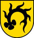
The blazon of the municipal coat of arms reads: "Black deer pole curved in yellow with a clover-leaf grind." The coat of arms used today appears for the first time in 1612 on a disk of the city of Zug. Originally it was the coat of arms of the noble von Rüti near Rohrbach in the canton of Bern , but it was released after they died out. It was finally introduced in 1933 and replaced the coat of arms that had been used in the meantime, an ax on a red background.
population
The population developed as follows:
| year | 1850 | 1900 | 1930 | 1950 | 1960 | 1970 | 1980 | 1990 | 2000 | 2010 |
| Residents | 539 | 409 | 461 | 479 | 471 | 437 | 506 | 714 | 1,097 | 1,350 |
On December 31, 2019, 1541 people lived in Oberrüti, the proportion of foreigners was 12.2%. In the 2015 census, 59.7% described themselves as Roman Catholic and 14.7% as Reformed ; 25.6% were non-denominational or of other faiths. 97.2% said German as their main language in the 2000 census .
Politics and law
The assembly of those entitled to vote, the municipal assembly , exercises legislative power. The executing authority is the five-member municipal council . He is elected by the people in the majority procedure, his term of office is four years. The parish council leads and represents the parish. To this end, it implements the resolutions of the municipal assembly and the tasks assigned to it by the canton. The District Court of Muri is primarily responsible for legal disputes . Oberrüti belongs to the peace judges' circle XIII (Muri).
economy
According to the corporate structure statistics (STATENT) collected in 2015, there are around 340 jobs in Oberrüti, 18% of them in agriculture, 33% in industry and 49% in the service sector. Most of the employed are commuters and work in the agglomerations of the cities of Lucerne and Zug .
traffic
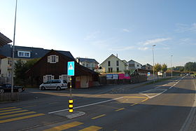
The main road Lenzburg - Lucerne runs right through Oberrüti. A connection to the A14 motorway is around four kilometers south. The village has a train station on the SBB railway line Aarau - Arth-Goldau . There is also a bus line operated by Zugerland Verkehrsbetriebe between the Sins and Gisikon - Root stations .
education
The community has a kindergarten and a primary school . All upper levels of the compulsory elementary school ( Realschule , Secondary School , District School ) can be attended in Sins . The closest grammar school is the Cantonal School in Wohlen .
Personalities
- Josef Villiger (1910–1992), dialect author
literature
- Anton Wohler: Oberrüti. In: Historical Lexicon of Switzerland .
- Georg Germann : The art monuments of the canton Aargau . Ed .: Society for Swiss Art History . Volume V: The Muri District. Birkhäuser Verlag, Basel 1967, DNB 457321970 .
- Franz Stöckli, Ulrich Widmer: Village history Oberrüti . Ed .: Community of Oberrüti. Oberrüti 2004.
Web links
Individual evidence
- ↑ Cantonal population statistics 2019. Department of Finance and Resources, Statistics Aargau, March 30, 2020, accessed on April 2, 2019 .
- ↑ Cantonal population statistics 2019. Department of Finance and Resources, Statistics Aargau, March 30, 2020, accessed on April 2, 2019 .
- ^ National map of Switzerland, sheets 1130 and 1131, Swisstopo.
- ↑ Standard area statistics - municipalities according to 4 main areas. Federal Statistical Office , November 26, 2018, accessed on May 10, 2019 .
- ^ Beat Zehnder: The community names of the canton of Aargau . In: Historical Society of the Canton of Aargau (Ed.): Argovia . tape 100 . Verlag Sauerländer, Aarau 1991, ISBN 3-7941-3122-3 , p. 329-331 .
- ^ Germann: The art monuments of the Canton of Aargau, Volume V: District of Muri.
- ^ Joseph Galliker, Marcel Giger: Municipal coat of arms of the Canton of Aargau . Lehrmittelverlag des Kantons Aargau, book 2004, ISBN 3-906738-07-8 , p. 240 .
- ↑ Population development in the municipalities of the Canton of Aargau since 1850. (Excel) In: Eidg. Volkszählung 2000. Statistics Aargau, 2001, archived from the original on October 8, 2018 ; accessed on May 8, 2019 .
- ↑ Resident population by religious affiliation, 2015. (Excel) In: Population and Households, Community Tables 2015. Statistics Aargau, accessed on May 10, 2019 .
- ↑ Swiss Federal Census 2000: Economic resident population by main language as well as by districts and municipalities. (Excel) Statistics Aargau, archived from the original on August 10, 2018 ; accessed on May 8, 2019 .
- ↑ circles of justice of the peace. Canton of Aargau, accessed on June 20, 2019 .
- ↑ Statistics of the corporate structure (STATENT). (Excel, 157 kB) Statistics Aargau, 2016, accessed on May 8, 2019 .


