Drumlin
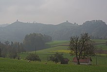
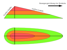
Drumlins (from Irish droimnín [ˈdrim´n´iːn´] "small ridge", "high ridge") are elongated hills with a teardrop-shaped floor plan, the longitudinal axis of which lies in the direction of the ice movement of a ( Ice Age ) glacier . Typical dimensions are a length of several 100 to several 1000 m at a height of 10 to, in individual cases, over 40 m. The streamlined bodies were sculpted under an actively moving glacier. They are part of the ground moraine landscape . Drumlins often appear as fan-shaped groups or staggered.
Emergence
In the erosion area of a glacier, the deposition of material predominates, not the erosion. It is unconsolidated sediment usually as boulder clay formed, which is deformable by ice pressure. According to Helmholtz's law, the interface between the glacier and its deformable subsurface is undulating. If the ground moraine material is a plastic mixture of water and sediments and the glacier hits a boulder or a slope, the ground moraine can release water under the pressure built up, so that the subglacial sediments solidify. In other cases, existing elevations and sediments such as older tertiary sands or existing moraines from earlier glacier phases were “driven over” by a later glacier. In both cases, they get their streamlined shape from the movement of the glacier.
Multiple radar observations under the Rutford Glacier in the Antarctic showed for the first time the formation of a drumlin around 10 m high and almost 100 m wide. The observation data rule out that drumlins are formed by selective erosion; rather, the glacier has to push loose material together to form the drumlins. Mathematical models that take unstable currents into account suggest that the typical sizes of drumlins can be explained by the wavelength of currents that occur when the ice layer is thinner than the typical drumlin length, but also occurs under certain circumstances with any ice thickness.
distribution
In Central Europe, drumlins are mainly known from the alpine glaciation area. The Lake Constance region north-west of Konstanz and north of Lindau , the Eberfinger Drumlinfeld near Weilheim in Upper Bavaria and the Zurich Oberland are examples of drumlin landscapes. In northern Germany, however, drumlins are a rare phenomenon. Ernst Th. Seraphim located some drumlins in the northern Teutoburg Forest in the area between Borgholzhausen and Versmold and between Bielefeld , Rheda-Wiedenbrück and Verl . There are, however, some Drumling areas in the young moraine area of Ireland , Poland and the Baltic States , but even there they only cover a few percent of the ground moraine area. It is controversial whether there are drumlins in the Brandenburg ground moraines. A possible representative there is the Kleine Rummelsberg .
In North America , however, drumlins are common.
Similar shapes
In contrast to the drumlins, the less streamlined and very elongated Oser were created by meltwater that flowed under the glacier.
The round humps, which are also similar to the drumlins, are not made of loose material, but of solid rock and have a slightly different shape. They are a form of glacial erosion .
See also
literature
- Karl Albert Habbe: On the origin of the drumlins of the South German Alpine Foreland (II): The sediments underneath. In: Risto Aario, Olavi Heikkinen (Ed.): Proceedings of the Third International Drumlin Symposium. Held June 26 to July 2 1990, Oulu, Finland (= Geomorphology. Vol. 6, No. 1, ISSN 0169-555X ). Elsevier, Amsterdam 1992, pp. 69-78, doi: 10.1016 / 0169-555X (92) 90049-T .
- Ernst Th. Seraphim: Drumlins of the Drenthe Stadium on the northeastern edge of the Westphalian Bay. In: Osnabrücker Naturwissenschaftliche Mitteilungen. Vol. 2, 1973, pages 41-87, ( digital version (PDF; 24.1 MB) ).
Web links
Individual evidence
- ^ Hans Murawski , Wilhelm Meyer : Geological dictionary. 12th, revised and expanded edition. Spectrum - Akademischer Verlag, Heidelberg 2010, ISBN 978-3-8274-1810-4 , page 33 f.
- ↑ The explanation follows: Frank Press , Raymond Siever : Allgemeine Geologie. 5th edition. Spectrum - Akademischer Verlag, Berlin et al. 2008, ISBN 978-3-8274-1812-8 , page 592.
- ↑ Andy M. Smith, Tavi Murray, Keith W. Nicholls, Keith Makinson, Guðfinna Aðalgeirsdóttir, Alberto E. Behar, David G. Vaughan: Rapid erosion, drumlin formation, and changing hydrology beneath an Antarctic ice stream. In: Geology. Vol. 35, No. 2, 2007, pages 127-130, doi: 10.1130 / G23036A.1 .
- ^ Richard CA Hindmarsh: The stability of a viscous till sheet coupled with ice flow, considered at wavelengths less than the ice thickness. In: Journal of Glaciology. Vol. 44, No. 147, 1998, pages 285-292, doi: 10.3198 / 1998JoG44-147-285-292 .
- ^ Andrew C. Fowler: The instability theory of drumlin formation applied to Newtonian viscous ice of finite depth. In: Proceedings of the Royal Society. Series A: Mathematical, Physical and Engineering Sciences. Vol. 466, No. 2121, 2010, pages 2673–2694, doi: 10.1098 / rspa.2010.0017 .
- ↑ Ernst Th. Seraphim: Drumlins of the Drenthe Stadium on the northeastern edge of the Westphalian Bay. In: Osnabrücker Naturwissenschaftliche Mitteilungen. Vol. 2, 1973, pp. 41-87, here p. 44.


