
Raderach
|
Raderach
City of Friedrichshafen
|
|
|---|---|
 |
|
| Height : | 475 m above sea level NHN |
| Residents : | 391 (Apr. 2016) |
| Incorporation : | 1st December 1971 |
| Postal code : | 88048 |
| Area code : | 07544 |
 Location of Raderach in Friedrichshafen
|
|
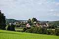
 Raderach
|
|
With around 400 inhabitants, Raderach is the smallest district of Friedrichshafen on Lake Constance . It is located six kilometers northwest of Friedrichshafen city center.
history
Raderach was first mentioned in a document in 1140 as "Radirai". To distinguish between the hamlet of Unterraderach, which belongs to Ailingen, the place was sometimes also called Oberraderach. In the 12th century there was an aristocratic family in the place called von Raderach .
Initially, these aristocrats used a fortification on the Weiherberg, today in the immediate vicinity of the Weiherberg disposal center, the so-called Old Castle . The fortification on the Kluftern district , which has been preserved as a typical castle stable , was first mentioned in 1160 by Werner von Raderach.
The so-called " New Castle " was built on the Drumlin , where Raderach is still located today. It is first mentioned in 1254 and was only canceled in 1836.
Local tradition puts the story of Rosa von Tannenburg on the "Old Castle" (Tannenburg) and the "New Castle" (Fichtenburg). As a result, there is a Fichtenburgstrasse in Raderach and a Tannenburgstrasse in Unterraderach, which is closer to the “Old Castle”.
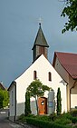
The garden restaurant of the Gasthaus Krone is located on the site of the residential castle that was demolished in 1836 . The last owner of the castle, Vinzenz Brugger, had it torn down stone by stone, apparently believing the rumors that treasure was hidden in the walls. From the demolition material, the inn, the neighboring farm and the chapel were built. From the original castle chapel, the trinity picture above the altar, which presumably came from the workshop of Jörg Zürn from Überlingen , became a valuable crucifixion group , a chalice that bears the year 1695 and a votive picture from 1744 that tells of the healing of an illness , taken over in the new chapel. In the cellar of the Gasthaus Krone you can still see the deep well, which supplied the castle with water all year round and was once outside the castle. According to recent investigations, the well was built about 60 meters deep and almost reaches lake level.
The von Raderach family owned large estates, which they mainly sold to the Salem monastery in the 13th century . The castle itself was sold to Count Mangold von Nellenburg in 1278 , who resold it to the Bishop of Constance in 1280 . He sold it to Werner von Raderach in 1289/91. From 1324 to 1616 the place was pledged to Constance ministers and later to Ravensburger patricians. The lower jurisdiction was incumbent on Constance, the high jurisdiction of the Austrian bailiwick of Swabia . In 1616 the place belonged to the Upper Bailiwick of Markdorf and in 1803 it came to Württemberg , but in 1806 to Baden . From 1811 the place belonged to the district office of Meersburg and in 1857 came to the district office of Überlingen , from which the district of Überlingen emerged in 1939. On December 1, 1971, Raderach was incorporated into Friedrichshafen together with Ailingen .
Between 1942 and 1945, parts for the V2 rocket were produced near Raderach in the Raderacher Forest using forced labor . In 1944 the outer works was bombed, but only marginally damaged. Production continued until the end of 1944. It was not until January 1945 that the area was cleared when French troops approached. On May 9, 1945, Professor Moureu, the co-founder of French rocket research and the forefather of Ariane , came to Oberraderach for a tour. He found the undestroyed test systems for the oxygen liquefaction, assembly halls and other facilities and had everything that was useful dismantled and transported to France. After the entire site was blown up by French occupiers in 1948, the site was used as a military training area until 1978. After the military training area was abandoned, Weiherberg was converted into a garbage dump in 1979. Large parts of the former V2 site disappeared under the now 38 meter high garbage mountain.
Personalities
The author and writer Josef Hoben comes from Raderach.
Fortification Heidengestied

On the Heidengestied , a drumlin north of Raderach, there are remains of an old fortification. From the almost rectangular fortification, which extends to about 26 × 34 meters, remnants of walls and moats can be clearly seen on the eastern and southern sides. The western side of the complex is still partially visible, the northern side is largely sanded. According to the Tettnang office description from 1915, it is a Celtic square hill, but this is doubted by the State Office for Monument Preservation, among others. The age and purpose of the facility, which is also referred to as a herd building on older land maps , are not known. Since the complex is neither mentioned in written sources, nor can comparable structures be found in the region, it can only be dated to the Middle Ages based on the features of the terrain.
politics
The residents of the village of Raderach take part in the municipal elections of Friedrichshafen as the residential district of Raderach . The municipal council election takes place according to the system of the false suburbs . A voluntary mayor and the local council, which are elected every five years, represent the interests of the citizens of Raderach in local politics. Bruno Mainz has been the mayor since 2014.
The local council is composed as follows (status: 2014 local council elections):
- Free citizens: 4 seats
- Independent citizens: 3 seats
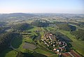
Aerial view with surroundings
Raderach
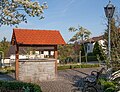
Fountain on Raderach village square

Former castle fountain, today in the basement of the inn


Web links
Individual evidence
- ↑ a b c Alois Schneider: Castles and fortifications in the Lake Constance district . Ed .: Landesdenkmalamt Baden-Württemberg (= Fund reports from Baden-Württemberg . Volume 14 ). 1st edition. E. Schweizerbart'sche Verlagsbuchhandlung, Stuttgart 1989, ISBN 3-510-49114-9 , pp. 557-558 .
- ↑ Information sheet for the local administration in Raderach, July 1996.
- ↑ Information board for the city of Friedrichshafen in front of the inn
- ^ Federal Statistical Office (ed.): Historical municipality directory for the Federal Republic of Germany. Name, border and key number changes in municipalities, counties and administrative districts from May 27, 1970 to December 31, 1982 . W. Kohlhammer, Stuttgart / Mainz 1983, ISBN 3-17-003263-1 , p. 534 .
- ↑ Thomas Kliebenschedel: A4 (V2) rocket production in Friedrichshafen 1942-45. on: v2werk-oberraderach.de
- ↑ State Office for Geoinformation and Rural Development, DGM 1 ( Memento from July 13, 2016 in the Internet Archive )
- ^ Christoph Morrissey, Dieter Müller: Wall systems in the administrative district of Tübingen . Ed .: Regional Council Stuttgart - State Office for Monument Preservation (= Atlas of archaeological land monuments in Baden-Württemberg . Volume 2/26 ). 1st edition. Konrad Theiss Verlag, Stuttgart 2011, ISBN 978-3-8062-2645-4 , p. 185 .
- ↑ https://www.raderach.de/unsere-ortschaft/ortschaftsrat/ Internet presence Raderach

Locations: Ailingen | Ettenkirch | Cliffs | Raderach
Districts: Allmannsweiler | Mountain | Efrizweiler | Fischbach | Hirschlatt | Hofen | Jettenhausen | Lipbach | Lion Valley | Manzell | Meistershofen | Schnetzenhausen | Sea moss | Windhag