Little Rummelsberg
| Little Rummelsberg | ||
|---|---|---|
| height | 81.1 m above sea level NN | |
| location | near Brodowin, Chorin community , Brandenburg ( Germany ) | |
| Mountains | Terminal moraine arch Chorin | |
| Coordinates | 52 ° 54 ′ 45 " N , 13 ° 58 ′ 55" E | |
|
|
||
| Type | ( Drumlin , very controversial) | |
| rock | Boulder clay , sand | |
| Age of the rock | approx. 16,500 years (Pomeranian stage of the Vistula Ice Age ) | |
| Normal way | Access possible, away from the Brodowin - Pehlitzer Werder road | |
| particularities | Under nature protection , dry grass | |
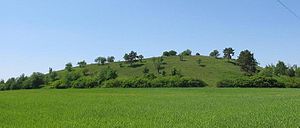
The Kleine Rummelsberg is a 81 meter high hill east of the village of Brodowin in the municipality of Chorin in the Brandenburg district of Barnim . The hill is the most important vantage point in the Brodowin landscape and offers a clear view in all directions. The neighboring Große Rummelsberg is around a meter higher but inaccessible. Occasionally both hills are combined under Rummelsberg . With its rare continental dry grassland , the Kleine Rummelsberg is under nature protection . It is disputed whether the mountain is a drumlin .
Drumlin question
The Kleine Rummelsberg is located directly on the east bank of the Wesensee and exceeds its water surface by 38 meters. At least until the High Middle Ages , the now isolated Wesensee formed a bay of the Parsteiner See .
The hill in the Schorfheide-Chorin Biosphere Reserve is geologically interesting in terms of the controversial and open question of whether it is a drumlin . Drumlins are elongated hills with a teardrop-shaped floor plan, the longitudinal axis of which lies in the former direction of ice movement of a ( Ice Age ) glacier and which were formed under an actively moving glacier. The Kleine Rummelsberg and other similarly shaped hills in its neighborhood belong to the backland of the terminal moraine arch Chorin south of the extensive Parsteiner See, a tongue basin lake of the Parsteiner Lobus . The geological conditions for the development of a "real" drumlin are given. At the foot of the mountain, the information sign of the Lower Nature Conservation Authority of the State of Brandenburg states:
- “In terms of geological origin, it is a drumlin, ie an embankment with an elliptical floor plan made of ground moraine material from the Pomeranian stage of the Vistula glaciation. "
Despite this attribution, the question of whether it is actually a drumlin and whether there are drumlins in Brandenburg at all is controversial among geologists. " When we are on the small Rummelsberg, we can in the area even more of such structures to see, and then it is an excellent argument over possible whether it is or that now at this a Drumlin, a Kame or Os is. “Possibly it is also simply a“ normal ”hill within the ground moraine landscape without any geomorphological specifics. Only boreholes that have not yet been carried out on the Kleiner Rummelsberg or on other alleged drumlins such as the Rosinberg on the west bank of the Parsteiner See could clarify this.
flora
The Kleine Rummelsberg is under nature protection because of its rich soil flora with a continental dry grassland , which due to the exposed position of the hill “could hold itself as the western branch of the steppe vegetation ”.
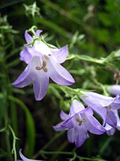
At this particular vegetation include flat-growing and dry soils preferring plant as Siberian bellflower ( Campanula sibirica ), the Natternkopf-hawkweed ( Hieracium echioides ), of the genus halbschmarotzender Wachtelweizen the melampyrum arvense ( Melampyrum arvense ), further the spiked blue loosestrife ( Pseudolysimachion spicatum (L.) Opiz = Veronica spicata ) and the herbaceous golden thistle ( Carlina vulgaris ).
Other representatives of the ground flora are the awl grass ( Stipa L. ), the up to one square meter carpets of sand thyme ( Thymus serpyllum ), the evergreen common brownelle ( Prunella vulgaris ), as ornament of the mountains (Oros = mountain and Ganos = ornament , Gloss) the spice oregano or the common dost ( Origanum vulgare ) and the meadow sage ( Salvia pratensis ), which particularly attracts bumblebees .
Footnotes
- ↑ Definition from Drumlin
- ↑ Information board of the Lower Nature Conservation Authority of the State of Brandenburg on site, as of May 2007
- ↑ A hike through the Ice Age landscape. Website of the Geological Garden Bolzenhagen, accessed on July 23, 2016
- ↑ Drumlins . Website of the Geological Garden Bolzenhagen; see also discussion: Drumlin # Rummelsberg
- ↑ Information board ...
literature
- Werner Stackebrandt and Volker Manhenke (eds.): Atlas zur Geologie von Brandenburg , State Office for Geosciences and Raw Materials Brandenburg (today: State Office for Mining, Geology and Raw Materials Brandenburg, LBGR), 2nd edition, 142 pages, 43 maps, Kleinmachnow 2002 , ISBN 3-9808157-0-6
- Lippstreu, L .; Hermsdorf, N .; Sunday, A .: Geological overview map of the state of Brandenburg 1: 300,000 - explanations. - Potsdam 1997, ISBN 3-7490-4576-3
Other web links
- Geology ( Memento from September 27, 2007 in the Internet Archive ) at www.barnim.de
- Biotope mapping Land Brandenburg, Volume II, p. 307f (Chapter 11152) pdf


