
Barnim district
| coat of arms | Germany map |
|---|---|

|

Coordinates: 52 ° 49 ' N , 13 ° 42' E |
| Basic data | |
| State : | Brandenburg |
| Administrative headquarters : | Eberswalde |
| Area : | 1,479.67 km 2 |
| Residents: | 185,244 (Dec. 31, 2019) |
| Population density : | 125 inhabitants per km 2 |
| License plate : | BAR, BER, EW |
| Circle key : | 12 0 60 |
| NUTS : | DE412 |
| Circle structure: | 25 municipalities |
| Address of the district administration: |
Am Markt 1 16225 Eberswalde |
| Website : | |
| District Administrator : | Daniel Kurth ( SPD ) |
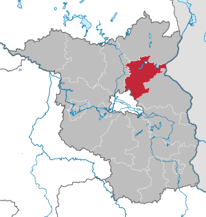
| Location of the district of Barnim in Brandenburg | |
  |
|
The Barnim district is a district in Brandenburg . It is named after the Pleistocene mountain range Barnim between the Eberswalder and the Berlin glacial valley.
geography
The district of Barnim borders in the north on the district of Uckermark , in the west on the district of Oberhavel , in the south on the state of Berlin and the district of Märkisch-Oderland . In the east, the German border with Poland ( West Pomeranian Voivodeship ) forms the county border.
While the southern part of the district lies on the Barnim plateau, the district town and its surroundings are in the Eberswalde glacial valley. The northern part of the district is already part of the Uckermark hills and in the northwest to the Schorfheide forest landscape . In the easternmost tip a small part of the district belongs to the valley of the lower Oder .
Of the total area, 46.3 percent are forests and around five percent are water areas.
Communities
(In brackets: number of residents on December 31, 2019)
The most populous city is the district town of Eberswalde with more than 40,000 inhabitants, followed by Bernau . In the entire district there are 25 large municipalities, three offices , three unofficial cities and four unofficial municipalities .
Unofficial cities
Other municipalities not subject to official duties
|
  |
Offices and associated municipalities
(seat of the official administration *)
|
1. Biesenthal-Barnim (12,273)
|
2. Britz-Chorin-Oderberg (10.121)
|
3. Joachimsthal (Schorfheide) (5249)
|
history
The district was formed by the Brandenburg district reform on December 5, 1993 from the former districts of Eberswalde (excluding the municipality of Bölkendorf ) and Bernau and the communities of Hohensaaten and Tiefensee from the former district of Bad Freienwalde . The naming of the district after Barnim also takes up the names of the predecessor districts Niederbarnim and Oberbarnim , which existed until 1952 , with the area of which today's district only partially corresponds. On January 1, 2009, the municipality of Hohensaaten moved from Bad Freienwalde (Oder) to the Märkisch-Oderland district .
Population development
|
|
|
Territory and number of inhabitants on December 31 of the respective year, from 2011 based on the 2011 census
- religion
In 2011, 12.7% of the population belonged to the Evangelical Church. 2.5% were Catholic. 84.8% of the respondents were non-denominational, linked to another religious community or did not provide any information.
politics
District council

Since the election on May 26, 2019, the 56 seats in the district council have been distributed among parties and groups of voters as follows:
| Party / group | Voices 2014 | Voices 2019 | Seats 2014 | Seats 2019 | |
|---|---|---|---|---|---|
| CDU | 21.4% | 16.5% | 12 | 9 | |
| THE LEFT | 24.8% | 15.6% | 14th | 9 | |
| AfD | 1.2% | 15.0% | 1 | 8th | |
| SPD | 18.6% | 13.4% | 10 | 8th | |
| BVB / FREE VOTERS | 8.4% | 13.0% | 5 | 7th | |
| GREEN / B90 | 6.9% | 10.9% | 4th | 6th | |
| FDP | 3.2% | 4.1% | 2 | 2 | |
| Civic parliamentary group BAR | 5.0% | 3.1% | 3 | 2 | |
| Farmers' Association BAR | 3.0% | 2.8% | 2 | 2 | |
| The party | - | 2.5% | - | 1 | |
| Schorfheide alliance | 1.5% | 1.7% | 1 | 1 | |
| Alliance for Bernau (BfB) | 1.7% | 1.1% | 1 | 1 | |
| NPD | 2.2% | x | 1 | - |
The district council is chaired by a chairman and convened at least every three months. It has eight specialist committees that are responsible for preparing the content of the decisions. The committees are: (1) district committee, (2) budget and finance, (3) auditing, (4) territorial planning, construction and housing, trade and economy, (5) agriculture, environmental protection and waste management, (6) health, senior citizens and Social affairs, (7) education and culture and (8) youth welfare.
District Administrator
- 1993-2018: Bodo Ihrke (SPD)
- since 2018: Daniel Kurth (SPD)
Kurth received 61.2% of the valid votes in the district council election on May 6, 2018. However, due to the low turnout of 18.7%, he missed the required quorum of 15% of eligible voters. As a result, the district council had to decide. On July 4, 2018, he elected Kurth as district administrator for eight years. Kurth took office on July 31, 2018.
Offices
The Brandenburg Soil Protection Office , the Lower Water Authority and the Lower Waste Management Authority are based in the district and are the contact persons for all questions and applications on water, forest and grassland in the region on behalf of the State Environment Ministry.
coat of arms
The coat of arms was approved on October 17, 1995.
Blazon : “Fourth of silver and red; above a growing, golden armed eagle in confused colors with golden clover stalks on the wings. "
The coats of arms of the offices, cities and municipalities of the district are included in the list of coats of arms in the district of Barnim .
Economy and Infrastructure
economy
The economy of the district consists of the main pillars of agriculture, manufacturing including handicrafts, tourism and services as well as energy and health. At the end of 2005 there were a total of 6668 farms of various sizes in agriculture. The business location Eberswalde is one of 15 regional growth centers in the state of Brandenburg. This promotes selected future-oriented industries.
In the Future Atlas 2016 , the Barnim district was ranked 312 out of 402 districts, municipal associations and urban districts in Germany, making it one of the regions with “future risks”.
traffic
Road traffic
The federal highways A 10 (Berliner Ring) and A 11 run from Berlin to Szczecin through the Barnim district . Seven federal highways open up the area ( B 2 , B 109 , B 158 , B 167 , B 168 , B 198 , B 273 ) together with numerous state and district roads .
Rail and ship traffic
The Berlin – Stettin / Stralsund railway via Eberswalde and Angermünde , together with the Wriezener Bahn , the Heidekrautbahn and some regional bus companies, form the backbone of public transport. The rail connection plays an important role for freight traffic, as does the Oder-Havel Canal, which runs in an east-west direction .
environment
Energy strategy - zero emissions

Since August 2008, the district of Barnim has been working on the implementation of the zero emissions strategy on the basis of a district council resolution. The aim is to meet the EU and federal government's climate protection requirements ahead of schedule in 2011. The model project is funded as part of the federal climate protection initiative.
The goal of providing 14 percent of the heating requirement from renewable energies by 2011 was half achieved by the end of 2008. The 20 percent reduction in climate-damaging CO 2 emissions by 2011 compared to 1990 is already within reach at 17 percent (2008). The increase in the proportion of electricity from renewable energies to 30 percent required by the energy strategy has already been exceeded by 44 percent.
Together with a wide variety of partners from business, municipalities, science and the citizens, numerous projects enliven the district's energy strategy.
Climate-friendly building
The administration of the Barnim district is based in the Paul-Wunderlich-Haus , a particularly energy-efficient building. In 2008 it was awarded the golden seal of approval from the German Sustainable Building Council (DGNB). The experience gained during the construction of the administration building led to the development of a sustainability guide for new buildings and renovation, which is the basis for tenders in the Barnim district. It is based on the DGNB criteria. The power supply for all district properties was switched to green electricity at the beginning of 2009.
Develop climate awareness
Another milestone in the implementation of the zero-emission strategy is the development of school project modules with the title "Commitment to renewable energies, climate and environmental protection at Barnimer schools", with which the mentioned topics can be flexibly integrated into the classroom.
In addition to numerous renewable energy systems (solar, biogas, biomass systems) that have arisen in the Barnim district, a Barnim village is developing into an energy village: Brodowin wants to convert its energy supply completely to renewable energies in the next few years and thus itself with electrical and Supply heat energy.
The district is also taking its first steps in the field of electromobility. After the inauguration of a publicly accessible charging station, the district's own vehicle fleet was expanded to include an electric vehicle.
Protected areas
There are 31 designated nature reserves in the district (as of February 2017).
License Plate
On January 1, 1994, the district was assigned the distinctive sign BAR and has been issued ever since. Since March 19, 2013, the distinctive signs BER (Bernau) and EW (Eberswalde) have also been available.
Incorporation and amalgamation of municipalities
The table shows the incorporations and mergers of municipalities since the district was formed on December 5, 1993.
| local community | date | Inclusion of | to | Merger of | to |
|---|---|---|---|---|---|
| Ahrensfelde | 10/26/2003 | Mehrow | Ahrensfelde | Ahrensfelde Blumberg Oak Lindenberg |
Ahrensfelde-Blumberg |
| Althüttendorf | 01/01/2003 | Neugrimnitz | Althüttendorf | ||
| Bernau | December 6, 1993 | Birch wood | Bernau | ||
| Bernau | 07/01/2001 | Ladeburg | Bernau | ||
| Bernau | December 31, 2002 |
Börnicke Lobetal |
Bernau | ||
| Bernau | 10/26/2003 | Schönow | Bernau | ||
| Biesenthal | 10/26/2003 | Danewitz | Biesenthal | ||
| Breydin | 09/27/1998 |
Hitchhike Tuchen-Klobbicke |
Breydin | ||
| Chorin | 09/27/1998 | Chorin Golzow Neuehütte Sandkrug Senftenhütte |
Chorin | ||
| Chorin | December 31, 2001 |
Brodowin Serwest |
Chorin | ||
| Eberswalde | December 6, 1993 |
Sommerfelde Tornow |
Eberswalde | ||
| Eberswalde | 01/01/2006 | Woodpecker houses | Eberswalde | ||
| Friedrichswalde | 02/01/2002 | Parlow-Glambeck | Friedrichswalde | ||
| Lunow-Stolzenhagen | 03/01/2002 |
Lunow Stolzenhagen |
Lunow-Stolzenhagen | ||
| Marienwerder | 05/01/2001 | Marienwerder Sophienstädt |
Marienwerder | ||
| Marienwerder | December 31, 2002 | Marienwerder Ruhlsdorf |
Marienwerder | ||
| Melchow | 09/27/1998 | Melchow Spechthausen |
Melchow | ||
| Melchow | 01/01/2006 | Spechthausen outsourcing |
Eberswalde | ||
| Panke Valley | 10/26/2003 |
Schwanebeck Zepernick |
Panke Valley | ||
| Parsteinsee | 03/01/2002 |
Ludersdorf Parstein |
Parsteinsee | ||
| Schorfheide | 12/30/1997 |
Eichhorst Finowfurt Lichterfelde Werbellin |
Finowfurt | ||
| Schorfheide | 12/30/2002 | Altenhof | Finowfurt | ||
| Schorfheide | 10/26/2003 |
Groß Schönebeck Finowfurt |
Schorfheide | ||
| Sydower Fliess | 09/27/1998 |
Grüntal temple fields |
Sydower Fliess | ||
| Wandlitz | 10/26/2003 |
Basdorf Klosterfelde Lanke Prenden Schönerlinde Schönwalde Stolzenhagen Wandlitz Zerpenschleuse |
Wandlitz | ||
| Werneuchen | December 31, 1998 | Löhme | Seefeld | ||
| Werneuchen | December 31, 2001 | Weesow | Werneuchen | ||
| Werneuchen | 10/26/2003 |
Hirschfelde Krummensee Schönfeld Seefeld Tiefensee Willmersdorf |
Werneuchen | ||
| Ziethen | 02/01/2002 |
Groß-Ziethen Klein Ziethen |
Ziethen |
On October 1, 2004, Ahrensfelde-Blumberg was renamed Ahrensfelde. The municipality of Hohensaaten changed on January 1, 2009 as a district of Bad Freienwalde (Oder) from the district of Barnim to the district of Märkisch-Oderland .
See also
literature
- Dakapo Press Office (Ed.): Barnim 2007/2008. The current data from cities, authorities and municipalities .
Web links
Individual evidence
- ↑ Population in the State of Brandenburg according to municipalities, offices and municipalities not subject to official registration on December 31, 2019 (XLSX file; 223 KB) (updated official population figures) ( help on this ).
- ↑ Population in the State of Brandenburg according to municipalities, offices and municipalities not subject to official registration on December 31, 2019 (XLSX file; 223 KB) (updated official population figures) ( help on this ).
- ^ Historical municipality register of the State of Brandenburg 1875 to 2005. District Barnim (PDF) pp. 8–9
- ^ Population in the state of Brandenburg from 1991 to 2015 according to independent cities, districts and municipalities . Table 7
- ^ Office for Statistics Berlin-Brandenburg (Ed.): Statistical report AI 1, A II 4. Population development and population status in the state of Brandenburg. (respective editions of the 4th quarter)
- ^ Barnim district: Population in regional comparison by religion
- ↑ Local elections in the state of Brandenburg on May 26, 2019 , p. 14
- ^ Result of the district administrator's election on May 6, 2018
- ↑ § 126 of the municipal constitution of the state of Brandenburg
- ↑ Daniel Kurth is the new district administrator in Barnim. In: Märkische Allgemeine , July 4, 2018
- ^ Barnimer district council elects new district administrator. on www.barnim.de
- ↑ Coat of arms information on the service portal of the state administration of Brandenburg
- ↑ Agriculture in Barnim (PDF) leaflet, 2005
- ↑ Future Atlas 2016. Archived from the original on October 2, 2017 ; accessed on March 23, 2018 .
- ↑ Description of the zero emissions target ( Memento from July 18, 2011 in the Internet Archive ) (PDF) in a Barnimer school network project; Retrieved January 25, 2010
- ↑ Historical municipality register of the State of Brandenburg 1875 to 2005. District Barnim (PDF) pp. 26–27.

Counties: Barnim | Dahme-Spreewald | Elbe Elster | Havelland | Märkisch-Oderland | Oberhavel | Oberspreewald-Lausitz | Oder-Spree | Ostprignitz-Ruppin | Potsdam-Mittelmark | Prignitz | Spree-Neisse | Teltow-Fläming | Uckermark
Independent cities: Brandenburg an der Havel | Cottbus | Frankfurt (Oder) | Potsdam