
Ostprignitz-Ruppin district
| coat of arms | Germany map |
|---|---|

|

Coordinates: 52 ° 59 ' N , 12 ° 38' E |
| Basic data | |
| State : | Brandenburg |
| Administrative headquarters : | Neuruppin |
| Area : | 2,526.55 km 2 |
| Residents: | 98,861 (Dec. 31, 2019) |
| Population density : | 39 inhabitants per km 2 |
| License plate : | OPR, KY, NP, WK |
| Circle key : | 12 0 68 |
| NUTS : | DE416 |
| Circle structure: | 23 municipalities |
| Address of the district administration: |
Virchowstrasse 14-16 16816 Neuruppin |
| Website : | |
| District Administrator : | Ralf Reinhardt ( SPD ) |
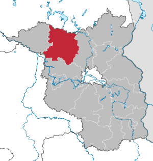
| Location of the Ostprignitz-Ruppin district in Brandenburg | |
  |
|
The district of Ostprignitz-Ruppin is a district in the northwest of the state of Brandenburg .
geography
The district of Ostprignitz-Ruppin comprises the eastern part of the Prignitz , the main part of the Ruppiner Land and the little Bellin of the Havelland . In terms of natural space , it is taken up by the Wittstock-Ruppiner Heide (including Ruppiner Switzerland ), the Neustrelitzer Kleinseenland ( Rheinsberger Seengebiet area ), the Ruppiner Platte , the Rhinluch and the Rüthnicker Heide .
Neighboring districts are the Mecklenburg- West Pomerania district of Mecklenburg Lake District in the north, the Oberhavel district in the east, the Havelland district in the south, the Stendal district of Saxony-Anhalt in the south-west and the Prignitz district in the west .
Five of the 100 largest municipalities in Germany (Wittstock / Dosse, Rheinsberg, Neuruppin, Fehrbellin, Heiligengrabe) belong to the district . Ostprignitz-Ruppin is the third largest district in Brandenburg and is in ninth place in Germany .
Communities
After the municipal reform in 2003, the district comprised 23 municipalities, including six cities.
In 2004, the municipalities of Herzsprung and Königsberg received a ruling from the state constitutional court that their compulsory incorporation into the city of Wittstock / Dosse on October 26, 2003 was null and void due to formal errors. They were administered by the Wittstock / Dosse office until they decided in which municipality they should be incorporated. Since January 1, 2005, they have been part of the Heiligengrabe community as districts .
(Residents on December 31, 2019)
Other municipalities not subject to official duties
|
Offices and associated communities 1. Lindow (Mark) (4561)
2. Neustadt (Dosse) (7659)
3. Temnitz (5384) (official seat: Walsleben)
|
  |
history
The district of Ostprignitz-Ruppin was created on December 6, 1993 as part of the Brandenburg district reform by merging the districts of Wittstock , Kyritz and Neuruppin . Efforts to unite the Ostprignitz with the current district of Prignitz in a district encompassing the whole of Prignitz were rejected by the state government.
In the area of the cities of Wittstock / Dosse, Rheinsberg and Neuruppin as well as the municipality of Temnitzquell is the former military training area Wittstock (Bombodrom). Plans by the federal government to develop it into an air-to-ground firing range for the Bundeswehr have been legally and politically controversial since 1993. In 2009, Federal Defense Minister Franz Josef Jung announced that he was not using the site.
Population development

|
|
|
Territory and number of inhabitants on December 31 of the respective year, from 2011 based on the 2011 census
politics
District council
Since the election on May 26, 2019, the 46 seats in the district council have been distributed among parties and groups of voters as follows:
| Party / group | Voices 2014 | Voices 2019 | Seats 2014 | Seats 2019 | |
|---|---|---|---|---|---|
| CDU | 22.4% | 20.1% | 10 | 9 | |
| SPD | 24.5% | 17.9% | 11 | 8th | |
| THE LEFT | 19.9% | 16.2% | 9 | 7th | |
| AfD | - | 12.7% | - | 6th | |
| GREEN / B90 | 7.3% | 10.0% | 4th | 5 | |
| Voting group of the Ostprignitz-Ruppin district farmers' association (WG KBV) | 9.8% | 9.5% | 5 | 4th | |
| BVB / FREE VOTERS | 4.2% | 5.6% | 2 | 3 | |
| FDP | 4.3% | 3.6% | 2 | 2 | |
| Pro Ruppin | 1.9% | 2.7% | 1 | 1 | |
| Free voter community Prignitz-Ruppin (FWG) | 2.6% | 1.8% | 1 | 1 | |
| Brandenburg municipality Ruppin (BG Ruppin) | 2.7% | - | 1 | - |
District Administrator
- 1994–2010: Christian Gilde (SPD)
- since 2010: Ralf Reinhardt (SPD)
Reinhardt received 59.0% of the valid votes in the district council election on May 6, 2018.However, due to the low turnout of 24.6%, he missed the required quorum of 15% of the eligible voters. As a result, the district council had to decide. On September 6, 2018, he elected Reinhardt as district administrator for a further term of eight years in accordance with § 72 (2) and 83 of the Brandenburg Local Election Act.
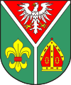
Coat of arms, official seal and flag
On May 2, 1993, the district received approval to use the coat of arms described below.
Blazon : “Split by a silver drawbar; above, in red, a gold-armored silver eagle; below in green in front a red-bound golden lily, behind a red-coated golden miter. “The eagle above in the coat of arms comes from the Counts of Arnstein, who ruled Ruppin in the 13th century. On the left a lily representing the Counts of Plotho, a Wendish family who ruled Kyritz, where they emigrated from the Magdeburg area and brought with them German families such as von Blumenthals. The miter on the right symbolizes Wittstock when Bishop Heinrich I made Wittstock the capital of the Principality of Havelberg.
The official seal shows, subject to other legal provisions, the district coat of arms with the inscription "LANDKREIS OSTPRIGNITZ-RUPPIN - DER LANDRAT".
The district flag is striped green - white - red (1: 2: 1) and has the district coat of arms in the center.
coat of arms

Official seal

flag


The coat of arms of the offices, cities and municipalities of the district is shown in the list of coats of arms in the Ostprignitz-Ruppin district .
partnership
A partnership with the Coesfeld district in North Rhine-Westphalia has existed since December 2018 .
Economy and Infrastructure
economy
Recreational tourism plays a role in the region with camping , hunting and water sports . Large parts are dominated by agriculture and forestry .
traffic
The A 19 and A 24 motorways run through the district .
The federal highways 5 , 102 , 103 , 112 , 122 , 167 and 189 run through the district.
Important railway lines in the area of the district are the lines Berlin – Hamburg , Wittenberge – Wittstock and Wittstock – Kremmen .
Protected areas
There are 18 designated nature reserves in the district (as of February 2017).
License Plate
On January 1, 1994, the district was assigned the distinctive sign OPR and has been issued ever since. Since March 18, 2013, the distinctive signs KY (Kyritz), NP (Neuruppin) and WK (Wittstock) have also been available.
Incorporation and amalgamation of municipalities
The table shows the incorporations and mergers of municipalities since the district was formed on December 5, 1993
Others
In the district area, East Low German Platt is occasionally spoken.
See also
literature
- Ulrike Schwarz, Matthias Metzler: Monument topography Federal Republic of Germany . Monuments in Brandenburg. District Ostprignitz-Ruppin 13.2 = community Fehrbellin, Amt Lindow (Mark) and city Rheinsberg . Wernersche Verlagsgesellschaft , Worms 2003. ISBN 978-3-88462-191-2
Web links
- Official website of the Ostprignitz-Ruppin district
Individual evidence
- ↑ Population in the State of Brandenburg according to municipalities, offices and municipalities not subject to official registration on December 31, 2019 (XLSX file; 223 KB) (updated official population figures) ( help on this ).
- ↑ Population in the State of Brandenburg according to municipalities, offices and municipalities not subject to official registration on December 31, 2019 (XLSX file; 223 KB) (updated official population figures) ( help on this ).
- ^ Historical municipality register of the state of Brandenburg 1875 to 2005. Landkreis Ostprignitz-Ruppin . Pp. 8-9
- ↑ Population in the state of Brandenburg from 1991 to 2015 according to independent cities, districts and municipalities , Table 7
- ^ Office for Statistics Berlin-Brandenburg (Ed.): Statistical report AI 1, A II 4. Population development and population status in the state of Brandenburg. (respective editions of the 4th quarter)
- ↑ Local elections in the state of Brandenburg on May 26, 2019 , p. 21
- ^ Result of the district administrator's election on May 6, 2018
- ↑ § 72 (2) of the Brandenburg Local Election Act
- ^ Drawing of lots saves the SPD district administrator in Ostprignitz-Ruppin. In: Märkische Allgemeine , September 6, 2018
- ↑ a b c Main statutes of the Ostprignitz-Ruppin district (PDF)
- ↑ Partner - now also by contract. In: Märkische Allgemeine , December 14, 2018
- ^ Historical municipality register of the state of Brandenburg 1875 to 2005. Landkreis Ostprignitz-Ruppin . Pp. 34-36.

Counties: Barnim | Dahme-Spreewald | Elbe Elster | Havelland | Märkisch-Oderland | Oberhavel | Oberspreewald-Lausitz | Oder-Spree | Ostprignitz-Ruppin | Potsdam-Mittelmark | Prignitz | Spree-Neisse | Teltow-Fläming | Uckermark
Independent cities: Brandenburg an der Havel | Cottbus | Frankfurt (Oder) | Potsdam