
Fehrbellin
| coat of arms | Germany map | |
|---|---|---|

|
Coordinates: 52 ° 49 ' N , 12 ° 46' E |
|
| Basic data | ||
| State : | Brandenburg | |
| County : | Ostprignitz-Ruppin | |
| Height : | 40 m above sea level NHN | |
| Area : | 270.41 km 2 | |
| Residents: | 8943 (Dec. 31, 2019) | |
| Population density : | 33 inhabitants per km 2 | |
| Postcodes : | 16818 (Albertinenhof, Altfriesack, Deutschhof, Kuhhorst, Langen, Ribbeckshorst, Wall, Wustrau, Zietenhorst) 16833 ( Fehrbellin , Betzin, Brunne, Dechtow, Hakenberg, Karwesee, Königshorst, Lentzke, Linum, Protzen, Tarmow, Walchow) 16845 (Manker) |
|
| Area code : | 033932 | |
| License plate : | OPR, KY, NP, WK | |
| Community key : | 12 0 68 117 | |
| LOCODE : | DE ZFE | |
| Address of the municipal administration: |
Johann-Sebastian- Bach-Str. 6 16833 Fehrbellin |
|
| Website : | ||
| Mayor : | Mathias Perschall ( SPD ) | |
| Location of the municipality of Fehrbellin in the Ostprignitz-Ruppin district | ||
  |
||

Fehrbellin (with an emphasis on the last syllable) is a municipality in the Ostprignitz-Ruppin district in Brandenburg .
geography
Fehrbellin is about 60 km northwest of Berlin and 12 km south of Neuruppin .
The eponymous core town of the municipality of Fehrbellin is located on the northern edge of the small country Bellin , a small mountain range. Larger parts of the municipality are located in the Havelländisches Luch south of the core town. The Rhinluch , through which the Rhin flows and is only three kilometers wide, extends north of the city center . In the late Middle Ages, the "Bellinsche Ferry " was operated at this point , from which the name of the city developed. With increasing sedimentation of the Lynx a ferry was used instead of the dam piled up, the Fehrbellin with Neuruppin connects. To the north of the Rhinluch lies the Ruppiner Platte . With an area of 268 km², Fehrbellin is one of the largest municipalities in Germany . The municipality has a share of the Zootzen forest .
Community structure
The community of Fehrbellin consists of the following districts, inhabited districts and residential areas:
Districts
The municipality of Fehrbellin is divided into 17 districts:
Betzin , Brunne , Dechtow , Deutschhof , Hakenberg , Karwesee , Königshorst , Langen , Lentzke , Linum , Manker , Protzen , City of Fehrbellin, Tarmow , Walchow , Wall , Wustrau-Altfriesack
Inhabited parts of the community
Inhabited parts of the municipality of Fehrbellin:
- District Deutschhof: Deutschhof, Dreibrück , Kuhhorst and Ribbeckshorst.
- District Langen: Langen and Dammkrug
- District of Königshorst: Königshorst, Lobeofsund, Mangelshorst, Nordhof, Sandhorst, Fredenhorst and Seelenhorst
- Wustrau-Altfriesack district: Wustrau, Altfriesack and Zietenhorst
Living spaces
The following places exist in the municipality:
Albertinenhof, Berlowshof, Hakenberger Schleuse, Lentzker Mühle, Lentzker Siedlung, Rollinsruhe, Schäferei and Theresiendorf
history
The castle guardian "Belin" (Fehrbellin) was first mentioned on December 28, 1216, when the Brandenburg Bishop Siegfried II confirmed his archdeaconate rights to the Brandenburg Cathedral Chapter when he took office . The city charter was Fehrbellin 1294. The ferry over the Rhinluch and a corduroy road are attested from the 1402nd Fehrbellin is on the Berlin – Wilsnack pilgrimage route , which has been committed since the end of the 14th century.
The current district of Walchow was first mentioned in a document in 1445 as walchouw . In the 17th century the place was completely destroyed. In the same century the Dutch and the Palatinate settled here.
In 1616 the Rhin bridge to Neuruppin was built. Since the beginning of the 17th century, the Feldberg village church served as the parish church for Fehrbellin and as the main church of the little country Bellin. Patronages were initially the bishops of Havelberg, then the lords of Bellin zu Bellin, and from 1657 the electoral office of Bellin.
Langen, Manker, Walchow and Wustrau were burned down by imperial troops in the Thirty Years War in 1638.
In the Battle of Fehrbellin in the Swedish-Brandenburg War , the Great Elector Friedrich Wilhelm von Brandenburg defeated on June 18 . / June 28, 1675 greg. the Swedes and after this victory conquered Swedish-Pomerania, which was ruled by the Swedes, by 1678 . On this occasion, Kaiser Wilhelm II gave the city of Fehrbellin a large equestrian statue of the Great Elector. It was created by the Berlin sculptor Fritz Schaper and unveiled on October 18, 1902. The battle is a central plot element in Heinrich von Kleist's drama Prince Friedrich von Homburg .
The Havelländisches Luch was drained in the early 18th century and the Rhinluch at the end of the century. Since 1840, peat mining, which served to supply Berlin with fuel, developed into an important branch of the economy.
Since 1880 the route of the Paulinenaue-Neuruppiner Railway ran through Fehrbellin. Passenger traffic ceased in 1970 and freight traffic in 1995. In 2011 a cycle path was built on the former railway line.
From 1940 to 1945 the Fehrbellin Labor Education Camp (AEL) existed, a women's prison camp of the Secret State Police . The inmates, mostly foreign forced laborers , had to work in the nearby bast fiber factory. After the war, the factory continued to produce bast fibers as VEB Märkische bast fiber until 1990.
Administrative history
Fehrbellin and its current districts of Betzin, Brunne, Dechtow, Deutschhof, Karwesee, Königshorst, Lentzke, Linum, Tarmow belonged to the Osthavelland district , Hakenberg, Langen, Manker, Protzen, Walchow, Wall, Wustrau and Altfriesack to the Ruppin district in the Prussian region since 1817 Brandenburg Province . In 1952 the places were incorporated into the Neuruppin district in the GDR district of Potsdam . Since 1993, they have been in the Ostprignitz-Ruppin district in Brandenburg.
On June 1, 1992, the city of Fehrbellin joined together with 16 communities from the then Neuruppin district (Wustrau-Altfriesack, Langen, Wall, Linum, Dechtow, Karwesee, Königshorst, Hakenberg, Brunne, Lentzke, Betzin, Protzen, Manker, Tarmow, Walchow and Deutschhof) to form the Fehrbellin Office.
On May 7, 2002, the Ministry of the Interior approved the merger of the municipalities of Betzin, Deutschhof, Hakenberg, Karwesee, Königshorst, Manker, Tarmow, Wall and the city of Fehrbellin to form the new municipality of Fehrbellin, which, however, only became legally effective on October 26, 2003. On October 26, 2003, the remaining municipalities of the Fehrbellin office, i.e. Brunne, Dechtow, Langen, Lentzke, Linum, Protzen, Walchow and Wustrau-Altfriesack, were incorporated into the Fehrbellin municipality by law. The Fehrbellin office was dissolved at the same time. Fehrbellin has been a titular town ever since . Formally, this can be recognized by the district name “Stadt Fehrbellin”.
Population development
|
|
|
|
|
Territory of the respective year, number of inhabitants: as of December 31 (from 1991), from 2011 based on the 2011 census
politics
Community representation
The community council of Fehrbellin consists of 18 community representatives and the full-time mayor. The local election on May 26, 2019 resulted in the following distribution of seats:
| Party / group of voters | Seats |
|---|---|
| Voters' association "Strong Villages" | 5 |
| CDU | 5 |
| SPD | 3 |
| LEFT | 2 |
| GREEN | 2 |
| Voting group "Brandenburg village Walchow" | 1 |
mayor
- 1998–2003: Klaus-Peter Rolf
- 2003–2019: Ute Behnicke (independent)
- since 2019: Mathias Perschall (SPD)
Perschall was elected in the mayoral election on September 1, 2019 with 50.9% of the valid votes for a term of eight years.
coat of arms
The coat of arms, by heraldist Frank Diemar , was approved on February 18, 1993.
Blazon : “In silver a two-tower, red church with ashlar masonry as a substructure and an open double-arched portal covered with a black rosette. The towers are each provided with four black windows as well as jagged, kneaded and crossed pointed roofs. Between the towers a growing, black-clad and sheltered monk's trunk. "
flag
The municipality's flag is three-lined red-white-red (red-silver-red) in a ratio of 1: 3: 1 with the coat of arms in the median.
Community logo

The municipality of Fehrbellin has had a joint logo for tourism and culture since October 27, 2005. It was confirmed as the official logo of the municipality of Fehrbellin in a competition advertised by the Fehrbellin municipal administration by resolution of the municipal representatives on October 27, 2005. The logo was designed by Tom Berger from Neuruppin, who is on the board of the non-profit association FKK Fehrbelliner Karneval Klub e. V. cooperates.
The logo combines the landscape elements Luchwiesen and forests as well as rivers and ponds as the predominant landscape in the municipality of Fehrbellin. The bronze victoria of the Victory Column near Hakenberg (Brandenburg) is also processed as a stylized element as an outstanding pictorial element. As a contrast, the eye of the beholder of this landscape stands in red.
Partnerships
Fehrbellin has had a town partnership with Dülmen in North Rhine-Westphalia since 1990 . Individual districts have also entered into further partnerships:
- District of Brunne with Momchilovtsi in southern Bulgaria
- District Langen with Langen (Hesse) , with Langen near Bremerhaven and with Kamenné Zboží in the Czech Republic
- District of Linum with Bolatice in the Czech Republic, with Rudy in Poland and with Nagykovácsi in northern Hungary
Attractions
Buildings
- City church (built 1865–66 according to plans by Stüler ) made of yellow brick in neo-Gothic style with a 41 meter high tower. The three-aisled church stands on the site of the late medieval church in the village of Feldberg, which was expanded around 1700. From the middle of the 19th century the church became too small for the city, which was growing due to the economic boom. In 1858, Stüler presented a draft for a new building, which was revised by the district architect Becker. In 1865 the demolition of the old church and the new construction began. This was consecrated in 1867. The bricks came from Lindow and Linum. After various renovations, the interior of the building was restored in 1998. With its monumental design, the church is one of the most important church buildings in a Brandenburg provincial town in the middle of the 19th century. It can be assumed that the commissioning of the royal master builder Stüler and the imposing size of the church should remind of Fehrbellin's importance for Brandenburg-Prussian history.
- Monument to the Great Elector (by Fritz Schaper , 1902)
- Monument to the Battle of Fehrbellin
- Memorial to the Fallen 1813–1815 (by Max Wiese )
- Dechtow village church, stone and brick building from the 15th (16th?) Century, tower with stepped gable from the 19th century
- Tarmow village church from 1835, a normal church in Schinkel
- Langen village church , brick building from 1855 (Stüler area)
- Wustrau village church , field stone building from the 13th century
- Neo-Gothic brick church Walchow, built in 1851/52
- Rentengutsiedlung from 1928–32, settlement of classical modernism, the appearance of which is, however, impaired by renovations
- Memorial from 1947 for the victims of fascism on OdF-Platz at the intersection of Geschwister-Scholl-Straße / Kapellenberg
Economy and Infrastructure
economy
Up until 1989 a textile company had around 700 employees. Today in Fehrbellin u. a. Companies in the construction industry, metalworking companies, agricultural machinery dealers and service providers and food producers are represented. Tourism plays an increasing role.
traffic
The former Paulinenaue – Neuruppin railway via Fehrbellin was partially shut down with the construction of the A 24 in 1970 and its entire length in 1994. This route is now largely developed as the Stille Pauline cycle expressway from Fehrbellin to Neuruppin and Paulinenaue. The cycle expressway deviates from the old railway line between Dammkrug and Neuruppin-Treskow. In this area it runs next to the L 16 state road.
Fehrbellin can be reached with a PlusBus and other regional bus routes through the Ostprignitz-Ruppiner local public transport company.
The Ruppiner Land airfield is located in the municipality .
The state road L 16 between Neuruppin and Kremmen crosses Fehrbellin. The state roads L 17, L 164, L 165 and L 173 also run through the municipality. Fehrbellin is connected to the A 24 (Berlin – Hamburg) with the Fehrbellin and Neuruppin-Süd exits .
education
- Johann Heinrich Bolte Primary School Fehrbellin
- High school "Schule am Rhin" Fehrbellin
- Small primary school in Königshorst
- Wustrau primary school
Personalities
Sons and daughters of the community and its districts
- Hans Joachim von Zieten (1699–1786), Prussian equestrian general, born in Wustrau
- Friedrich Wilhelm Wolff (1816–1887), sculptor
- Robert Jacobs (1832–1897), District Administrator
- Bernhard Bohm (1841–1896), member of the Reichstag, born in Brunne
- Friedrich Wilhelm Ludwig von Schwerin (1862–1925), District President, born in Wustrau
- Hans Schönfeld (1900–1954), Protestant theologian
- Karl Gutschmidt (1937–2012), Slavist
- Kurt Hintze (1901–1944), SS brigade leader and major general of the police
- Frank Jeske (1960–1994), football player, born in Wustrau
Personalities associated with the community
- Johann Heinrich Bolte (1750-1817), clergyman and school reformer, worked in Fehrbellin
- Ehrhardt Bödecker (1925–2016), founder of the Brandenburg-Prussia Museum in Wustrau
- Winfried Kräuter (* 1956), soccer player, grew up in Fehrbellin
- Yvonne Tratz (* 1957), camerawoman, lives in Fehrbellin
Others
The Fehrbelliner Reitermarsch (composed in 1893 by Richard Henrion ), regimental march of various units of the Bundeswehr, is well known .
photos

Former Fehrbellin train station
Bützrhin near Wall

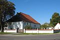
Church in Brunne

Former bast fiber factory

Manor house in Wall

Stüler Church

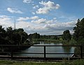
Wustrauer Rhin at the city park

Memorial to the Battle of Fehrbellin

Monument to the Great Elector Friedrich Wilhelm in the Elector Park

Memorial to the Fallen 1813–1815

Church in Betzin
Stable house in Deutschhof

Church in Dechtow

Cemetery in Dechtow

Karweseer Str. 2 in Dechtow

Church in Karwesee

Church in Langen

Village Peat School Museum in Protzen

Church in Tarmow
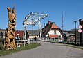
"The fisherman's dream" and bascule bridge in Wustrau-Altfriesack

Zietenhorst housing estate 4


literature
- Ulrike Schwarz, Matthias Metzler: Monument topography Federal Republic of Germany . Monuments in Brandenburg. District Ostprignitz-Ruppin 13.2 = community Fehrbellin, Amt Lindow (Mark) and city Rheinsberg . Wernersche Verlagsgesellschaft , Worms 2003. ISBN 978-3-88462-191-2
Web links
Individual evidence
- ↑ Population in the State of Brandenburg according to municipalities, offices and municipalities not subject to official registration on December 31, 2019 (XLSX file; 223 KB) (updated official population figures) ( help on this ).
- ↑ a b Fehrbellin community from the service portal of the state administration of the state of Brandenburg
- ↑ a b Main statutes of the municipality of Fehrbellin from March 19, 2009 PDF
- ↑ Cord Pagenstecher: The Fehrbellin Labor Education Camp in Northwest Brandenburg. In: Contemporary history regional. Messages from Mecklenburg-Western Pomerania. 6 (1). 2002, p. 112 f. (Online version as PDF; 24 kB)
- ↑ Website of the Fehrbellin labor education camp at berliner-geschichtswerkstatt.de
- ^ Formation of the Fehrbellin Office. Announcement of the Minister of the Interior of May 30, 1992. Official Gazette for Brandenburg - Joint Ministerial Gazette for the State of Brandenburg, Volume 3, Number 47, of July 10, 1992, p. 890.
- ^ Formation of a new parish in Fehrbellin. Announcement of the Ministry of the Interior of May 7, 2002. Official Gazette for Brandenburg - Joint Ministerial Gazette for the State of Brandenburg, Volume 13, Number 22, of May 19, 2002, p. 561.
- ↑ Fifth law on state-wide municipal reform concerning the districts of Barnim, Märkisch-Oderland, Oberhavel, Ostprignitz-Ruppin, Prignitz, Uckermark (5th GemGebRefGBbg) of March 24, 2003 (Law and Ordinance Gazette for the State of Brandenburg, I (Laws), 2003 , No. 05, p. 82 and amended by the law of July 1, 2003 (Law and Ordinance Gazette for the State of Brandenburg, I (Laws), 2003, No. 10, p. 187))
- ^ Historical municipality register of the state of Brandenburg 1875 to 2005. Landkreis Ostprignitz-Ruppin . Pp. 14-17
- ↑ Population in the state of Brandenburg from 1991 to 2017 according to independent cities, districts and municipalities , Table 7
- ^ Office for Statistics Berlin-Brandenburg (Ed.): Statistical report AI 7, A II 3, A III 3. Population development and population status in the state of Brandenburg (respective editions of the month of December)
- ^ Result of the local election on May 26, 2019
- ↑ Results of the municipal elections in 1998 (mayoral elections) for the Ostprignitz-Ruppin district ( memento of the original from April 13, 2018 in the Internet Archive ) Info: The archive link was automatically inserted and not yet checked. Please check the original and archive link according to the instructions and then remove this notice.
- ↑ Local elections October 26, 2003. Mayoral elections , p. 29
- ↑ Brandenburg Local Election Act, Section 74
- ^ Result of the mayoral election on September 1, 2019
- ↑ Coat of arms information on the service portal of the state administration of the State of Brandenburg and according to the main statute of March 19, 2009.
- ^ Website Fehrbellin - Home , accessed on August 23, 2018
- ↑ Ulrike Schwarz, Matthias Metzler: Monument topography Ostprignitz-Ruppin (= monuments in Brandenburg vol. 13.2), Worms 2003, p. 44 ff. ISBN 3-88462-191-2 .
Betzin | Well | Dechtow | Deutschhof | Hakenberg | Karwesee | Königshorst | Long | Lentzke | Linum | Manker | Splurge | City of Fehrbellin | Tarmow | Walchow | Wall | Wustrau old frieze sack
Breddin | Dabergotz | Dreetz | Fehrbellin | Holy Tomb | Herzberg (Mark) | Kyritz | Lindow (Mark) | Märkisch Linden | Neuruppin | Neustadt (Dosse) | Rheinsberg | Rüthnick | Sieversdorf-Hohenofen | Storbeck-Frankendorf | Stüdenitz-Schönermark | Temnitzquell | Temnitztal | Vielitzsee | Walsleben | Wittstock / Dosse | Wusterhausen / Dosse | Zernitz-Lohm