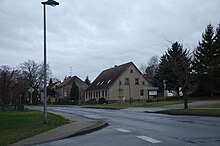
Manker (Fehrbellin)
Manker is a district of the municipality of Fehrbellin in the Ostprignitz-Ruppin district in the state of Brandenburg . The street village has a size of 16.7 km², in October 2009 321 inhabitants lived here.
geography
Manker is 11 kilometers northwest of Fehrbellin. The district is located on the northern edge of the Rhinluches . Manker is located on the L 165 between the Temnitztal district of Garz and Protzen .
history
The first documentary mention probably comes from the year 1365. The name Manker is unclear, but indicates a flour processing profession. But it is also conceivable that the name is of Slavic origin and comes from the first name Mąkaŕ (with nasal a). A tower at Manker is mentioned in 1388, a jug is mentioned in 1590. Around 1490 Manker was part of the Ruppin rule, which was essentially imperial, under the rule of the Counts of Lindow-Ruppin . Later it belonged to the district of Ruppin of the Mark Brandenburg , from 1815 the province of Brandenburg . The village was destroyed in the Thirty Years War , but it was rebuilt. In 1722 there were 240 inhabitants in Manker. In 1860 there were two brickworks and a flour mill in Manker. The place had 590 inhabitants in 1891.
After an LPG type I was closed in 1954, an LPG type III was founded. 1958 belonged the village completely to this LPG. Manker has been part of the Fehrbellin office since 1992, and has been a part of Fehrbellin since 2003.
Architectural monuments
The village characterizes the uniform appearance in the middle. All architectural monuments are in the list of architectural monuments in Fehrbellin . The most important are:
The village church was built in the second half of the 13th century. In the 15th or early 16th century the church was renovated in the late Gothic style. From 1713 to 1716 the church was changed again significantly, so it was lengthened to the east by twice. The pulpit altar inside also dates from this period. The baptismal font was created in the first half of the 18th century. The organ dates from 1865 and was installed by Friedrich Hermann Lütkemüller from Wittstock.
The syringe house is by the church and was built in 1915. It is a brick building with a hose tower.
The homestead with the "Villa Falkenberg" was built in 1899 as part of a four-sided courtyard. The floor plan is rectangular, but the house is equipped with risalits strongly divided. There is a turret with a pointed helmet on the corner of the house at the end of the town.
The house on the property at Dorfstrasse 47 was built at the end of the 18th century. The house is two-story and has a half-hip roof.
The former school farm with the village school is located at Dorfstraße 56. The homestead was built in 1889. The brick building is a typical building from the time of construction.
Personalities
- Werner Pöls (* 1926 in Manker; † 1989 in Braunschweig), historian and politician ( CDU )
- Anton Henning (* 1964 in Berlin), artist, lives and works in Manker
literature
- Monument topography Federal Republic of Germany, monuments in Brandenburg, district Ostprignitz-Ruppin, part 2: Fehrbellin community, Lindow (Mark) and city of Rheinsberg, Ulrike Schwarz and Matthias Metzler and others, Wernersche Verlagsgesellschaft, Worms am Rhein, 2003, ISBN 3-88462- 191-2 , pages 330-340
Web links
Individual evidence
Coordinates: 52 ° 50 ′ 43 " N , 12 ° 40 ′ 40" E

