Splurge
|
Splurge
Fehrbellin parish
Coordinates: 52 ° 50 ′ 27 ″ N , 12 ° 43 ′ 16 ″ E
|
||
|---|---|---|
| Height : | 40 m | |
| Incorporation : | October 26, 2003 | |
| Postal code : | 16833 | |
|
Location of Protzen in Brandenburg |
||
The village of Protzen is part of the municipality of Fehrbellin with around 500 inhabitants. It is located on the northern edge of the Rhinluches , south of the Ruppiner Platte . The A 24 runs east of the village . This can be reached via the Neuruppin-Süd junction about four kilometers away.
history

Protzen is a street village of Slavic origin and was first mentioned as a parish village in 1324. The place name is said to be derived from Slavic , from "place where millet grows". The village with its stone church is on the pilgrimage route from Berlin to Wilsnack . Around 1490 Protzen was part of the Ruppin rule, which was essentially imperial, under the rule of the Counts of Lindow-Ruppin .
During the Thirty Years War in 1638 the village was destroyed. In the years 1718, 1727, 1823, and 1831, further major destruction by fires followed. The von Gadow , Quast , Kleist , Drieberg , and Legde families were among the owners of the local estate .
As the peat began to be extracted, the village population doubled to over 500 between 1874 and 1892.
Theodor Fontane describes Protzen and its inhabitants in detail in one of his works. He wrote that the manor park was one of the most beautiful manor parks in the region.
Incorporation
Protzen was incorporated into Fehrbellin on October 26, 2003.
Attractions
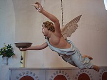
The late Romanesque stone church dates from the 13th century, the tower was built in 1682. It is a hall with a square choir. Inside there is a pulpit altar from 1778. The baroque baptismal angel comes from the same time or a little later. The organ was created in 1869.
The manor house, built around 1755, is an eaves, two-storey house. It has seven axes, the roof is a half-hip roof. There are two side wings behind the house. After 1945 the manor house was used as a school and as a residential building. Today's manor park has a baroque predecessor. The park was converted into a landscape park from 1823. Today the village, peat and school museum is located in the manor house.
Personalities
- Friedrich Johann von Drieberg (1780–1856), composer, inventor and writer
literature
- Monument topography Federal Republic of Germany, monuments in Brandenburg, Ostprignitz-Ruppin district. Part 2: Ulrike Schwarz, Matthias Metzler and others: Fehrbellin municipality, Lindow (Mark) office and Rheinsberg city. Wernersche Verlagsgesellschaft, Worms am Rhein 2003, ISBN 3-88462-191-2 , pp. 340–346.
- Robert Rauh : Show off . In: Fontanes Ruppiner Land. New walks through the Mark Brandenburg. Berlin 2019, ISBN 978-3-86124-723-4
Individual evidence
- ^ Theodor Fontane: Hike through the Mark Brandenburg. The county of Ruppin. 5th edition. 1892.
- ↑ StBA Area: changes from 01.01. until December 31, 2003
- ↑ Information on Protzen and the museum (PDF; 84 kB)


