
Vielitzsee (municipality)
| coat of arms | Germany map | |
|---|---|---|

|
Coordinates: 52 ° 56 ' N , 13 ° 1' E |
|
| Basic data | ||
| State : | Brandenburg | |
| County : | Ostprignitz-Ruppin | |
| Office : | Lindow (Mark) | |
| Height : | 50 m above sea level NHN | |
| Area : | 22.19 km 2 | |
| Residents: | 487 (Dec. 31, 2019) | |
| Population density : | 22 inhabitants per km 2 | |
| Postal code : | 16835 | |
| Area code : | 033933 | |
| License plate : | OPR, KY, NP, WK | |
| Community key : | 12 0 68 437 | |
| Office administration address: | Strasse des Friedens 20 16835 Lindow (Mark) |
|
| Website : | ||
| Mayor : | Dieter Fischer | |
| Location of the community of Vielitzsee in the Ostprignitz-Ruppin district | ||
  |
||

Vielitzsee is a municipality in the Ostprignitz-Ruppin district in Brandenburg . It is administered by the Office Lindow (Mark) , based in Lindow (Mark) .
geography
Vielitzsee is located about 15 kilometers east of the district town of Neuruppin on the eponymous Vielitzsee . The lake extends north of the town center, has an area of 120 hectares and is a maximum of three meters deep. Other lakes in the immediate vicinity of Vielitzsee are the Große Strubensee and the Glambecksee .
The village of Vielitz forms the center of the community and is located on a hill above the Vielitzsee. It is characterized by large brick courtyards . While the older part of the village extends along the edge of the bank embankment , the other - separated by a green area - extends to the southeast.
Community structure
The districts of Seebeck, Strubensee and Vielitz as well as the residential areas Alte Ziegelei, Expansion Vielitz, Neu Seebeck, Ravenhorst and Siedlung belong to the community of Vielitzsee.
history
Vielitz, Seebeck and Strubensee belonged to the Ruppin rule since the 14th century, to the Ruppin district in the Mark Brandenburg since 1524 and to the Neuruppin district in the GDR district of Potsdam from 1952 . Seebeck and Strubensee were merged on May 1, 1970 to form the Seebeck-Strubensee community. Since 1993 the places have been in the Ostprignitz-Ruppin district of Brandenburg.
The community of Vielitzsee emerged on December 31, 2001 from the voluntary merger of the previously independent communities of Vielitz and Seebeck-Strubensee.
Population development
| year | Seebeck- Strubensee |
Vielitz | year | Vielitzsee | year | Vielitzsee | ||
|---|---|---|---|---|---|---|---|---|
| 1971 | 335 | 273 | 2001 | 532 | 2015 | 463 | ||
| 1981 | 298 | 222 | 2005 | 567 | 2016 | 458 | ||
| 1990 | 270 | 206 | 2010 | 546 | 2017 | 463 | ||
| 1995 | 327 | 218 | 2011 | 479 | 2018 | 464 | ||
| 2000 | 313 | 240 | 2012 | 467 | 2019 | 487 | ||
| 2013 | 456 | |||||||
| 2014 | 473 |
Territory of the respective year, number of inhabitants: as of December 31 (from 1991), from 2011 based on the 2011 census
politics
Community representation
The community council of Vielitzsee consists of eight community representatives and the honorary mayor. The local election on May 26, 2019 resulted in the following distribution of seats:
| Party / group of voters | Seats |
|---|---|
| List Association Free Voters Vielitz | 4th |
| We for Vielitzsee | 2 |
| Single applicant Oliver Hacker | 1 |
| FDP | 1 |
mayor
- since 2003: Dieter Fischer
Fischer was elected in the mayoral election on May 26, 2019 with 69.6% of the valid votes for a further term of five years.
Attractions
In the list of architectural monuments in Vielitzsee and in the list of ground monuments in Vielitzsee are the cultural monuments entered in the list of monuments of the state of Brandenburg.
The district of Vielitz is the location of a stone church , which is lined with old chestnut and linden trees.

Kirchstrasse in Vielitz

Vielitzsee
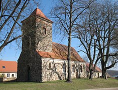
Vielitz Church

Vielitz Church

Seebeck Church

Strubensee Church


traffic
Vielitz is on the K 6803 district road between Lindow (Mark) and Herzberg (Mark) .
The closest train stations are Herzberg (Mark) and Lindow (Mark) . They are served by the regional train line RB 54 ( Löwenberg – Rheinsberg ).
Web links
- Vielitz in the RBB program Landschleicher on February 28, 2010
Individual evidence
- ↑ Population in the State of Brandenburg according to municipalities, offices and municipalities not subject to official registration on December 31, 2019 (XLSX file; 223 KB) (updated official population figures) ( help on this ).
- ^ Service portal of the state administration Brandenburg. Vielitzsee community
- ^ Historical municipality register of the state of Brandenburg 1875 to 2005. Landkreis Ostprignitz-Ruppin . P. 35
- ↑ StBA: Changes in the municipalities in Germany, see 2001
- ^ Historical municipality register of the state of Brandenburg 1875 to 2005. Landkreis Ostprignitz-Ruppin . Pp. 22-25
- ↑ Population in the state of Brandenburg from 1991 to 2017 according to independent cities, districts and municipalities , Table 7
- ^ Office for Statistics Berlin-Brandenburg (Ed.): Statistical report AI 7, A II 3, A III 3. Population development and population status in the state of Brandenburg (respective editions of the month of December)
- ^ Result of the local election on May 26, 2019
- ↑ Local elections October 26, 2003. Mayoral elections , p. 29
- ↑ Brandenburg Local Election Act, Section 73 (1)
- ^ Result of the mayoral election on May 26, 2019
Breddin | Dabergotz | Dreetz | Fehrbellin | Holy Tomb | Herzberg (Mark) | Kyritz | Lindow (Mark) | Märkisch Linden | Neuruppin | Neustadt (Dosse) | Rheinsberg | Rüthnick | Sieversdorf-Hohenofen | Storbeck-Frankendorf | Stüdenitz-Schönermark | Temnitzquell | Temnitztal | Vielitzsee | Walsleben | Wittstock / Dosse | Wusterhausen / Dosse | Zernitz-Lohm