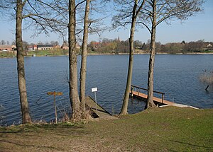
Vielitzsee
| Vielitzsee | ||
|---|---|---|

|
||
| Vielitzsee in Vielitz | ||
| Geographical location | Germany , Brandenburg , Ostprignitz-Ruppin district | |
| Tributaries | Adderlaake | |
| Drain | Vielitz Canal | |
| Places on the shore | Vielitzsee , Seebeck | |
| Location close to the shore | Lindow (Mark) | |
| Data | ||
| Coordinates | 52 ° 56 '38 " N , 13 ° 0' 13" E | |
|
|
||
| Altitude above sea level | 38.6 m above sea level NHN | |
| surface | 1.2 km² | |
| length | 4 km | |
| width | 300 m | |
| Maximum depth | 3 m | |
|
particularities |
Rinnensee |
|
The Vielitzsee is a lake in the area of the community of Vielitzsee in the Brandenburg district of Ostprignitz-Ruppin .
The lake extends south of Lindow (Mark) in a south-easterly direction. It has an area of 120 hectares and is a maximum of three meters deep. The villages of Vielitz and Seebeck are at its southern tip . It is connected to the Gudelacksee and further with the Havel via the Vielitz Canal and is thus part of the Ruppin waterway .
The water quality is checked monthly and is suitable for bathing.
See also
Individual evidence
- ↑ Press release from the Ostprignitz-Ruppin district on the 2017 swimming season , February 15, 2017, accessed on November 26, 2017
- ↑ Top water quality at the end of the bathing season , Märkische Oderzeitung , September 4, 2014, accessed on November 26, 2017
Web links
Commons : Vielitzsee (lake) - Collection of images, videos and audio files
Panorama at the east end of the lake

