Ruppiner Wasserstraße
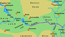
The Ruppiner Wasserstraße or the Ruppiner Gewässer waterway is a state waterway. It begins at the eastern end of the Vielitzsee and ends at the transition to the Ruppiner Canal at the end of the Kremmener See .
National waters
The Ruppin waters are part of the navigable state waters. The Brandenburg State Environment Agency (LUA) is subject to maintenance. The section of water is looked after by the Neuruppin branch of the State Environment Agency. The Landesschifffahrtsverordnung (LSchiffV) of April 25, 2005 (GVBl. Part II No. 10 p. 166) applies to shipping on the navigable state waters. The upper traffic authority in the State Office for Building and Transport (LBV) is responsible. The basis is usually the respective state water law . In addition, the Landesschifffahrtsverordnung (LSchiffV) applies to shipping.
course
The length of the waterway is 56.29 kilometers. The Rhin flows through these waters and their lakes. From the Vielitzsee you can reach the Gudelacksee via the Vielitz Canal, which is around one kilometer long . The Vielitz Canal was expanded like a canal in the 19th century to connect some of the brickworks on the Vielitzsee with the Ruppin waters. The Möllensee joins the Gudelacksee . Other lakes in the Ruppiner waters are the Zermützelsee , the Tetzensee , the Molchowsee and the Ruppiner See . This is followed by the Bützsee and the Kremmener See.
Locks
- Tiergarten lock , in Oranienburg
- Hohenbruch lock , in Hohenbruch , Kremmen
- Lock Altfriesack , in Altfriesack , Fehrbellin
- Lock Alt Ruppin , in Alt Ruppin , Neuruppin
See also
Web links
- Decree on the conservation and use of navigable state waters in the state of Brandenburg (PDF file) accessed on January 14, 2019
Individual evidence
- ↑ Port and Shipping Authority of the State of Brandenburg , accessed on January 14, 2019.
- ↑ Section 46 (2) of the Brandenburg Water Act (BbgWG) , State Government of Brandenburg. accessed on January 14, 2019
- ↑ country Marine Regulation (LSchiffV) , state government of Brandenburg. accessed on January 14, 2019
Coordinates: 52 ° 57 ′ 59 ″ N , 12 ° 58 ′ 48 ″ E

