
Oberhavel district
| coat of arms | Germany map |
|---|---|

|

Coordinates: 52 ° 55 ' N , 13 ° 13' E |
| Basic data | |
| State : | Brandenburg |
| Administrative headquarters : | Oranienburg |
| Area : | 1,808.18 km 2 |
| Residents: | 212,914 (Dec. 31, 2019) |
| Population density : | 118 inhabitants per km 2 |
| License plate : | OHV |
| Circle key : | 12 0 65 |
| NUTS : | DE414 |
| Circle structure: | 19 municipalities |
| Address of the district administration: |
Adolf-Dechert-Strasse 1 16515 Oranienburg |
| Website : | |
| District Administrator : | Ludger Weskamp ( SPD ) |
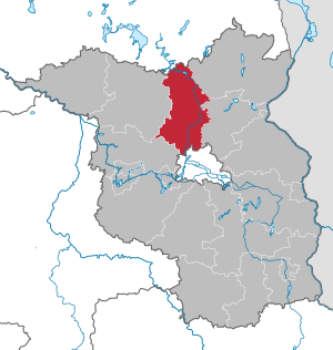
| Location of the Oberhavel district in Brandenburg | |
  |
|
The Oberhavel district is a district in the north of Brandenburg . The county seat is Oranienburg .
geography
The Oberhavel district extends as a sectoral district from the southern border of Mecklenburg-Western Pomerania to the northern border of Berlin . The upper course of the Havel river is eponymous and flows through the district from north to south. More than 50% of the area of the district are landscape or nature reserves.
The north of the district is taken up by the natural area of the Neustrelitz Kleinseenland . There are the two largest lakes in the district: the Great Stechlinsee (4.1 km²) in the Rheinsberg lake area and the Stolpsee (3.7 km²) on the edge of the Himmelpforter Heide . The Granseer Platte , which is characterized by arable fields , connects to the south . With the Großer Wentowsee (2.8 km²) and the Dreetzsee (1.7 km²) it includes the third and fourth largest lake in the district. One of the largest wet forest complexes on the Granseer Platte is the Harenzacken .
The middle part of the district is also taken up by the Zehdenick-Spandauer Havelniederung , the forest landscapes Rüthnicker Heide and Schorfheide , the Rhinluch with the Kremmener Luch and the Eberswalder Valley . In the southern part of the district, the Gliens plateau with the Krämer forest area , the wooded West Barnim with the Herthamoor and the Havelländische Luch extend .
The district has a share in the following historical landscapes : in the north on Mecklenburg ( Fürstenberger Werder ), in the northeast and east on the Uckermark , in the southeast on Barnim , in the southwest on Havelland and in the west and northwest on Ruppiner Land . In the middle part is the historic Löwenberg region .
Neighboring districts are the Mecklenburg Lake District (Mecklenburg-Western Pomerania) in the north, the Uckermark and Barnim districts in the east, the Berlin and Havelland district in the south and the Ostprignitz-Ruppin district in the west .
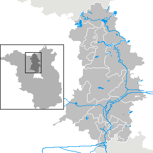
Communities
After the municipal reform was completed in 1993, the district comprised 19 municipalities, including nine towns. 14 of the municipalities are vacant .
(Residents on December 31, 2019)
Other municipalities not subject to official duties
|
Office and associated municipalities
|
  |
history
The Oberhavel district was created as a result of the Brandenburg district reform on December 6, 1993 by amalgamating the former Gransee and Oranienburg districts .
Population development

|
|
|
Territory and number of inhabitants on December 31 of the respective year, from 2011 based on the 2011 census
politics
District council
Since the election on May 26, 2019, the 56 seats in the district council have been distributed among parties and groups of voters as follows:
| Party / group | Voices 2014 | Voices 2019 | Seats 2014 | Seats 2019 | |
|---|---|---|---|---|---|
| CDU | 26.5% | 18.9% | 15th | 11 | |
| SPD | 27.8% | 17.9% | 15th | 10 | |
| AfD | - | 14.8% | - | 8th | |
| GREEN / B90 | 7.2% | 12.8% | 4th | 7th | |
| THE LEFT | 19.4% | 12.3% | 11 | 7th | |
| BVB / FREE VOTERS | 5.5% | 6.5% | 3 | 4th | |
| FDP | 3.1% | 5.2% | 2 | 3 | |
| Citizens for Oberkrämer (BfO) | - | 2.3% | - | 1 | |
| Agriculture, horticulture, environment (LGU) | 1.1% | 1.6% | 1 | 1 | |
| Pirates | 1.9% | 1.5% | 1 | 1 | |
| PRO VELTEN | - | 1.4% | - | 1 | |
| Animal welfare party | - | 1.2% | - | 1 | |
| NPD | 3.9% | 0.9% | 2 | 1 | |
| Citizens' Alliance of Free Voters (BB) | 1.2% | 0.9% | 1 | - | |
| The independents | 1.9% | 0.5% | 1 | - |
District Administrator and Head of Department
District Administrator of the district Oberhavel is 2015 since June 12 Ludger Weskamp (SPD). The previous district administrator was Karl-Heinz Schröter (SPD) from 1994 to 2014 . With Schröter's appointment as Minister of the Interior of the State of Brandenburg , the First Alderman of the Egmont Hamelow District (CDU) temporarily ran official business.
Weskamp achieved 60.1% of the valid votes in the district council election on March 8, 2015. However, due to the low turnout of 20.7%, he missed the required quorum of 15% of eligible voters. As a result, the district council had to decide. On May 27, 2015, he elected Weskamp as district administrator for a term of eight years in accordance with Section 72 (3) of the Brandenburg Local Election Act.
| suggestion | Surname | function | Area of responsibility | |
|---|---|---|---|---|
| SPD | Ludger Weskamp | District Administrator | ||
| CDU | Egmont Hamelow | Head of Department and Deputy District Administrator | Department I - Building, Economy and Environment | |
| ( independent ) | Kerstin Niendorf | Head of Department | Department II - Education, Youth and Health | |
| SPD | Matthias Kahl | Head of Department | Department III - Labor and Social Affairs | |
| CDU | Matthias Rink | Head of Department | Department IV - Service, Finances and Order |
(As of May 1, 2019)
coat of arms
The coat of arms was approved on May 18, 1994. Blazon : “Divided by silver over green; above gold-armored and red-tongued red eagles, the wings covered with golden clover stems; below two red-armored silver swans flying offset next to each other. "
Partner circles
The Oberhavel district maintains partnerships with the following districts:
- Vogelsbergkreis , Hesse
- Siedlce district , Republic of Poland
- Biała Podlaska County , Republic of Poland
In addition, friendly relationships are maintained with:
- Hudson County , USA
- Tampere city , Finland
- Taiwan
Economy and Infrastructure
In the 2016 Future Atlas , the Oberhavel district was ranked 302nd out of 402 districts, municipal associations and urban districts in Germany, making it one of the regions with a “balanced risk-opportunity mix” for the future.
Companies

The focus of the industry is in the south of the district, in the closer interlinked area with Berlin. In addition to the service sector, these include companies in the transport technology and steel industry (especially in and around Hennigsdorf) as well as the chemical and pharmaceutical industry (in and around Oranienburg). The business locations of Oranienburg, Hennigsdorf and Velten form one of 15 regional growth centers in the state of Brandenburg.
The entire district is also characterized by intensive agriculture .
Oberhavel is also becoming increasingly important as a local recreation area for Berlin and especially the north of the district as a natural holiday region.
traffic
The A 10 motorway (Berliner Ring) and the A 111 motorway branching off from it lead through the Oberhavel district in the direction of Berlin and the A 24 in the direction of Hamburg. In addition, the federal highways 96 , 96a , 109 , 167 and 273 run through the district.
The most important railway lines are the Berlin Outer Ring , the Berlin Northern Railway to Stralsund and the Kremmener Bahn to Neuruppin . Lines of Berlin train operate according Oranienburg and Hennigsdorf . The district's own Oberhavel Verkehrsgesellschaft is the operator of bus transport in the district. It is based in Oranienburg and operates 42 bus routes (2014). The Havel and Oder-Havel Canal are important inland waterways . In addition to a large number of local and regional cycle paths, the Berlin-Copenhagen long-distance cycle path and the Havel cycle path also lead through the district.
License Plate
On January 1, 1994, the district was assigned the distinctive symbol OHV and has been issued since then.
Incorporation and amalgamation of municipalities
The table shows the incorporations and mergers of municipalities since the district was formed on December 5, 1993.
See also
- List of churches in the Oberhavel district
- List of places in the Oberhavel district
- List of coats of arms in the Oberhavel district
Web links
Individual evidence
- ↑ Population in the State of Brandenburg according to municipalities, offices and municipalities not subject to official registration on December 31, 2019 (XLSX file; 223 KB) (updated official population figures) ( help on this ).
- ↑ a b Landscapes in Germany. Federal Agency for Nature Conservation , accessed on August 12, 2015 .
- ↑ Population in the State of Brandenburg according to municipalities, offices and municipalities not subject to official registration on December 31, 2019 (XLSX file; 223 KB) (updated official population figures) ( help on this ).
- ^ Historical municipality register of the state of Brandenburg 1875 to 2005. Oberhavel district . Pp. 8-9
- ↑ Population in the state of Brandenburg from 1991 to 2015 according to independent cities, districts and municipalities , Table 7
- ^ Office for Statistics Berlin-Brandenburg (Ed.): Statistical report AI 1, A II 4. Population development and population status in the state of Brandenburg. (respective editions of the 4th quarter)
- ↑ Local elections in the state of Brandenburg on May 26, 2019 , p. 19
- ^ Result of the district administrator's election on March 8, 2015 ( Memento of July 4, 2016 in the Internet Archive )
- ↑ Ludger Weskamp elected by the district council as the new district administrator on www.oberhavel.de
- ↑ CDU parliamentary group Oberhavel Presentation-Deputy. District Administrator. Retrieved June 17, 2013 .
- ^ Structure of the Oberhavel district administration. Retrieved October 21, 2018 .
- ↑ Coat of arms information on the service portal of the state administration of Brandenburg
- ↑ a b partnerships. In: Website of the district of Oberhavel. Retrieved February 4, 2019 .
- ↑ Future Atlas 2016. Archived from the original on October 2, 2017 ; accessed on March 23, 2018 .
- ^ Company growth core OHV
- ^ Economic region of the Oberhavel district
- ^ Leisure and tourism in the Oberhavel district
- ^ Historical municipality register of the State of Brandenburg 1875 to 2005. Landkreis Oberhavel (PDF) pp. 26–27.

Counties: Barnim | Dahme-Spreewald | Elbe Elster | Havelland | Märkisch-Oderland | Oberhavel | Oberspreewald-Lausitz | Oder-Spree | Ostprignitz-Ruppin | Potsdam-Mittelmark | Prignitz | Spree-Neisse | Teltow-Fläming | Uckermark
Independent cities: Brandenburg an der Havel | Cottbus | Frankfurt (Oder) | Potsdam