Fürstenberger Werder

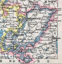
The (more rarely: the) Fürstenberger Werder (also Fürstenberger Zipfel ) is a historical landscape in the north of the state of Brandenburg . From 1348 to 1950 it belonged to Mecklenburg . The main town of Werder is the city of Fürstenberg / Havel .
geography
On July 1, 1950, the Fürstenberger Werder consisted of one town and six communities:
Since the municipal reform in 2003 , the area has belonged to the cities of Fürstenberg / Havel and Gransee and to the municipality of Großwoltersdorf . The Fürstenberger Werder borders in the north, east and south-east on the Uckermark , in the south on the state of Löwenberg , in the south and west on the Ruppiner Land and in the north-west on the rest of Mecklenburg. Geographically, the area is determined by the neustrelitz little lakes region and the Granseer plate taken.
history
In 1348 the Fürstenberger Werder came from the Mark Brandenburg to Mecklenburg and became part of the Stargard rule . Since the loss of the state of Lychen by Mecklenburg an Brandenburg with the Peace of Wittstock in 1442, the Fürstenberger Werder protruded as an elongated, narrow bulge facing southeast deep into the area of the Mark Brandenburg. The southeast boundary was formed by the Great Wentowsee and the Havel . In the 16th and 17th centuries, its forests were probably the last location for a population of wood grouse in Mecklenburg. In 1701 the Fürstenberger Werder became part of the new Mecklenburg-Strelitz region .
Around 1800 the Fürstenberger Werder was divided into the city of Fürstenberg , the Fürstenberg office and the areas of the Mecklenburg knighthood . In 1934 it became part of the Stargard district of the newly created state of Mecklenburg , initially with the exception of the city of Fürstenberg, which remained independent until 1935. In 1938 the Prussian exclave Großmenow came to Fürstenberger Werder as part of an area swap and was incorporated into Steinförde . From 1946 the Fürstenberger Werder belonged to the Neustrelitz district . On July 1, 1950, the city of Fürstenberg and the other communities of Fürstenberger Werder were reclassified from the state of Mecklenburg to the Templin district of the state of Brandenburg . A brief exception was the municipality of Buchholz , which was first reclassified to the Brandenburg district of Ruppin on July 1, 1950 , and finally also to the district of Templin after a month. This ended the 600-year history of the Fürstenberger Werder in Mecklenburg.
literature
- Geographical Institute of the Academy of Sciences of the GDR (Hrsg.): The Rheinsberg-Fürstenberger Seengebiet. Results of the local history inventory in the areas of Zechlin, Rheinsberg, Fürstenberg and Himmelpfort (= values of our homeland . Volume 25 ). Akademie-Verlag, Berlin 1974, DNB 750097159 .
- Wolfgang Stegemann: Fürstenberg / Havel - Ravensbrück. Contributions to the cultural history of a region between Brandenburg and Mecklenburg. Hentrich & Hentrich, Berlin.
Web links
Individual evidence
- ↑ a b II lit. b Ordinance for the implementation of the law of June 28, 1950 on changing the borders of the states. From July 13, 1950. In: Documents of the 33rd meeting of the Provisional Government of the GDR on July 13, 1950. Federal Archives (Germany) , accessed on September 19, 2014 (Figure No. 50).
- ^ Friedrich von Meyenn: Capercaillies in Mecklenburg . In: Yearbooks of the Association for Mecklenburg History and Archeology . tape 70 , 1905, pp. 263-266 ( full text ).
Coordinates: 53 ° 8 ' N , 13 ° 10' E