
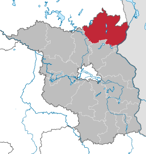
Uckermark district
| coat of arms | Germany map |
|---|---|

|

Coordinates: 53 ° 13 ' N , 13 ° 52' E |
| Basic data | |
| Existing period: | 1993– |
| State : | Brandenburg |
| Administrative headquarters : | Prenzlau |
| Area : | 3,076.93 km 2 |
| Residents: | 118,947 (Dec. 31, 2019) |
| Population density : | 39 inhabitants per km 2 |
| License plate : | UM, ANG, PZ, SDT, TP |
| Circle key : | 12 0 73 |
| NUTS : | DE418 |
| Circle structure: | 34 municipalities |
| Address of the district administration: |
Karl-Marx-Strasse 1 17291 Prenzlau |
| Website : | |
| District Administrator : | Karina Dörk ( CDU ) |
| Location of the Uckermark district in Brandenburg | |
  |
|

The district of Uckermark is a district in northeast Brandenburg . From December 1993 to September 2011 it was the largest district in Germany with an area of 3,058 km² .
geography
The district of Uckermark is located in the extreme northeast of the state of Brandenburg on the border with the Republic of Poland . The area of the district covers most of the lake-rich Uckermark region , while the smaller northern part of the Uckermark landscape belongs to Mecklenburg-Western Pomerania (Mecklenburg Lake District and Western Pomerania-Greifswald district). With the Gartz (Oder) office , the former West Pomeranian areas again belong to the Brandenburg district of Uckermark. In the southwest, the district has a share in the Schorfheide forest area .
Neighbors in the north are the Mecklenburg- Western Pomerania districts Mecklenburgische Seenplatte and Vorpommern-Greifswald , in the south the district Barnim and in the west the district Oberhavel . The Oder forms the longest part of the border with Poland in the east . On the Polish side are the districts of Police (Pölitz) and Gryfino (Greifenhagen).
Metropolitan area of Szczecin
The district has been actively developed since 2012 through cooperation within the metropolitan area of the metropolis of Szczecin as part of a European metropolitan region, the joint development concept was presented in June 2015.
Nature reserves
There are 72 nature reserves in the Uckermark district . The largest ( Melzower Forest ) has an area of 2,830.66 hectares , the smallest ( Eiskellerberge-Os near Malchow ) an area of 5.16 hectares.
Communities


After the municipal structural reform was completed in 2003, there are 34 municipalities in the Uckermark district, including seven cities.
(Residents on December 31, 2019)
Other municipalities not subject to official duties
|
  |
Offices and associated municipalities
(seat of the official administration *)
|
1. Brüssow (Uckermark) (4429)
2. Gartz (Oder) (6799)
|
3. Gerswalde (4401)
4. Gramzow (6778)
|
5. Or catfish (5365)
|
history
For centuries until 1945, the Uckermark was part of the Prussian province of Brandenburg as a historical landscape stretching over several districts . Its area west of the Oder-Neisse border was reconstituted as a land within the Soviet occupation zone .
In the course of the dissolution of the federal states in the GDR, which was founded in 1949 , the Uckermark with the Prenzlau , Strasburg and Templin districts came to the Neubrandenburg district , the Angermünde district was assigned to the Frankfurt (Oder) district . The city of Schwedt / Oder became an independent city in the Frankfurt (Oder) district.
With the countries neoplasm 1990, the Uckermark came except for Mecklenburg-Vorpommern remaining city Strasburg and one north of the present border of Brandenburg running along the strip with the villages Nieden, Schmarsow, Rollwitz, Damerow, Züsedom, Fahrenwalde and others to the country Brandenburg . Citizens' surveys in the Prenzlau and Templin districts resulted in a very clear vote in favor of belonging to the state of Brandenburg. In a referendum, the citizens of the city of Brüssow and 15 other West Pomeranian communities in the districts of Pasewalk and Strasburg decided to move to Brandenburg.
On December 6, 1993, as part of the Brandenburg district reform, the district of Uckermark with the district town of Prenzlau was formed from the former districts of Angermünde , Prenzlau , Templin and the formerly independent city of Schwedt / Oder. The northeastern part of today's Uckermark district does not belong to the historical Uckermark and was part of the Prussian province of Pomerania until 1945 .
Population development

|
|
|
Territory and number of inhabitants on December 31 of the respective year, from 2011 based on the 2011 census
politics
District council
The 50 seats in the district council , which was elected on May 26, 2019, are distributed among the individual parties and groups as follows :
| Party / group | Voices 2014 | Voices 2019 | Seats 2014 | Seats 2019 | |
|---|---|---|---|---|---|
| CDU | 27.0% | 21.7% | 14th | 11 | |
| SPD | 27.9% | 21.2% | 14th | 10 | |
| AfD | 2.1% | 15.4% | 1 | 8th | |
| THE LEFT | 18.1% | 13.2% | 9 | 7th | |
| GREEN / B90 | 3.7% | 7.7% | 2 | 4th | |
| BVB / FREE VOTERS | 2.9% | 7.2% | 1 | 3 | |
| FDP | 5.9% | 6.2% | 3 | 3 | |
| Farmers - Rural Areas (BLR) | 6.1% | 5.6% | 3 | 3 | |
| NPD | 3.1% | 1.2% | 2 | 1 | |
| Citizens' community "Save the Uckermark" | 2.6% | - | 1 | - | |
| Others | 0.7% | 0.8% | - | - |
District Administrator

- 1994–2002: Joachim Benthin (CDU)
- 2002–2010: Klemens Schmitz (formerly SPD, then non-party)
- 2010–2018: Dietmar Schulze (SPD)
- since 2018 Karina Dörk (CDU)
Klemens Schmitz achieved 50.8% of the valid votes in the district administrator's election on March 14, 2010. However, due to the low turnout of 29.1%, it missed the required quorum of 15% of eligible voters. As a result, the district council had to decide. On April 21, 2010, he elected Dietmar Schulze as district administrator in accordance with Section 72 (3) of the Brandenburg Local Election Act.
Karina Dörk was elected as the new district administrator for a term of eight years in the district administrator's election on May 6, 2018 with 67.6% of the valid votes.
coat of arms
The coat of arms was approved on November 8, 1995 and has been official since January 1, 1996. It was designed by Hans Benthin from Berkholz.
Blazon : “In gold, a multiple notched blue bar covered with two silver threads, covered by a gothic red brick tower with an open archway covered with silver plastered surfaces and with tinned wall wings; the masonry covered with two outwardly leaning silver pointed shields, inside on the right a golden armored, red eagle with golden clover stalks on the wings, on the left an upright, golden armored red griffin. "
The coats of arms of the offices, cities and municipalities of the district can be found in the list of coats of arms in the district of Uckermark .
Economy and Infrastructure
economy
In the Future Atlas 2016 , the district of Uckermark was ranked 392 out of 402 districts, municipal associations and independent cities in Germany and is therefore one of the regions with "very high future risks". The district is one of the structurally weakest in Germany.
A growth core with a brand-wide impact has formed around the largest developed commercial area in the district on 850 hectares around the PCK refinery and the paper mills in Schwedt / Oder. Other important pillars of the economy are agriculture, regenerative energies (production of solar modules in Prenzlau ), biogas systems in farms and through wind power plants throughout the district, as well as tourism. More and more visitors come to the region through the three major conservation areas ( Lower Oder Valley National Park , Schorfheide-Chorin Biosphere Reserve and the Uckermärkische Seen Nature Park ).
In the Uckermark, 6,200 companies are registered with the IHK and the Chamber of Crafts.
58 percent (176,549 ha ) of the region is agricultural land, of which z. B. tobacco is grown on 75 hectares.
traffic
Federal trunk roads
The federal highways federal highway 11 , federal highway 20 as well as federal highway 2 , federal highway 158 and federal highway 166 run through the district area .
Railway networks
The railway lines run through the district from Berlin to Stralsund , to Stettin and to Schwedt / Oder .
As early as 1842, the Berlin-Stettiner Eisenbahn-Gesellschaft began to include what is now the district in its network. The first to be built was the connection from Berlin to Angermünde , which was extended to Stettin the following year. In 1863 the Angermünde – Prenzlau – Pasewalk line was built to Anklam in Western Pomerania .
In 1873 Schwedt on the Oder was connected to the railway network from Angermünde by the Angermünde-Schwedt Railway Company. This was followed in 1877 by a cross connection to Bad Freienwalde (Oder) (in the direction of Küstrin ) by the Berlin-Stettiner Eisenbahn-Gesellschaft.
In 1888, the Prussian State Railroad opened up the old district of Templin from the Löwenberg (Mark) station on the Berlin Northern Railway with a line that ran to Prenzlau station in 1899 , and built a line from Fürstenberg to Eberswalde in 1898/1899 . The two routes made Templin a local hub.
The routes from Prenzlau to Strasburg and Damme- Brüssow were completed in 1898 by the Prenzlauer Kreisbahnen . In the following years, the network grew by extensions and branches, namely in 1902 to Fürstenwerder (Kreisbahn), Löcknitz and Klockow and in 1906 through the Angermünder Kreisbahn from Damme to Schönermark on the Stettiner Bahn. From 1908 the narrow- gauge Klockow – Pasewalk small railway continued north from Klockow ; however, only for freight traffic until the post-war period .
The Prussian State Railways also added the routes to the rail network in 1913
- (Templin–) Fährkrug – Fürstenwerder Reichsbahn and
- Tantow-Gartz
The Casekow – Penkun – Oder small railway has been operating a narrow-gauge railway between Oder and Randow-Bruch since 1899, which led to the suburbs of Stettin.
Waterways
The inland waterways Havel-Oder-Wasserstraße , Oder and Westoder and the port of Schwedt are located in the eastern part of the district.
License Plate
On January 1, 1994, the district was assigned the distinctive UM mark and has been issued ever since.
Until about the year 2000 vehicles from the old districts received special identification numbers:
| area | Letters | numbers |
|---|---|---|
| Altkreis Prenzlau | A to G | 1 to 999 |
| AA to GZ | ||
| Altkreis Angermünde and the city of Schwedt / Oder | H to R | |
| HA to RZ | ||
| Altkreis Templin | S to Z | |
| SB to ZZ |
Since April 3, 2014, the distinctive signs ANG (Angermünde), PZ (Prenzlau), SDT (Schwedt / Oder) and TP (Templin) have been available.
Incorporation and amalgamation of municipalities
The table shows the incorporations and mergers of municipalities since the district was formed on December 5, 1993.
| local community | date | Inclusion of | to | Merger of | to |
|---|---|---|---|---|---|
| Angermünde | December 31, 2000 | Altkünkendorf | Angermünde | ||
| Angermünde | 10/26/2003 |
Biesenbrow Bölkendorf Bruchhagen Crussow Frauenhagen Gellmersdorf Görlsdorf Greiffenberg Günterberg Herzsprung Kerkow Mürow Neukünkendorf Schmargendorf Schmiedeberg Steinhöfel Stolpe Welsow Wilmersdorf Wolletz |
Angermünde | ||
| Boitzenburger Land | December 31, 2001 |
Berkholz Boitzenburg Buchenhain Funkenhagen Hardenbeck Haßleben Jakobshagen Klaushagen Warthe Wichmannsdorf |
Boitzenburger Land | ||
| Bruessow | December 31, 2001 |
Bagemühl Brüssow Grünberg Woddow Wollschow |
Bruessow | ||
| Carmzow-Wallmow | December 31, 2001 |
Carmzow Wallmow |
Carmzow-Wallmow | ||
| Casekow | December 31, 2002 | Woltersdorf | Casekow |
Blumberg Casekow Luckow-Petershagen Wartin |
Casekow |
| Casekow | 10/26/2003 | Biesendahlshof | Casekow | ||
| Flieth-Stegelitz | December 31, 2001 |
Flieth Stegelitz |
Flieth-Stegelitz | ||
| Gartz (Or) | December 31, 2002 |
Friedrichsthal Gartz (Oder) Geesow Hohenreinkendorf |
Gartz (Or) | ||
| Gerswalde | December 31, 2001 |
Friedenfelde Gerswalde Groß Fredenwalde Kaakstedt Krohnhorst |
Gerswalde | ||
| Gramzow | December 31, 2001 | Gramzow Lützlow Meichow Poland |
Gramzow | ||
| Grünow | December 31, 1997 |
Damme Drense Grünow |
Grünow | ||
| Hohenselchow-Groß Pinnow | 10/26/2003 |
Groß Pinnow Hohenselchow |
Hohenselchow-Groß Pinnow | ||
| Lychen | December 31, 2001 |
Beentz Retzow Rutenberg |
Lychen | ||
| Mark Landin | December 31, 2001 |
Grünow Land in Schönermark |
Mark Landin | ||
| Mescherin | December 31, 2002 | Mescherin Neurochlitz Radekow Rosow |
Mescherin | ||
| Milmersdorf | 07/01/1993 |
Ahrensdorf (outsourcing) |
Milmersdorf | ||
| Milmersdorf | December 31, 2001 | Big Kölpin | Milmersdorf | ||
| Northwestuckermark | December 6, 1993 |
Naugarten (outsourcing) |
Schönermark | ||
| Northwestuckermark | December 01, 1997 |
Röpersdorf Sternhagen |
Röpersdorf-Sternhagen | ||
| Northwestuckermark | December 01, 1997 |
Arendsee Parmen Weggun |
Weggun | ||
| Northwestuckermark | December 31, 1997 |
Falkenhagen Holzendorf |
Holzendorf | ||
| Northwestuckermark | 05/01/1998 |
Beenz Gollmitz |
Gollmitz | ||
| Northwestuckermark | 11/01/2001 |
Ferdinandshorst Fürstenwerder Gollmitz Holzendorf Kraatz Naugarten Röpersdorf / Sternhagen Schapow Schönermark Weggun |
|||
| Oberuckersee | December 31, 2001 |
Blankenburg Potzlow Seehausen Warnitz |
Oberuckersee | ||
| Passow | December 31, 1998 |
Briest Jamikow Passow |
Catfish break | ||
| Passow | 10/26/2003 | Schönow | Catfish break | ||
| Prenzlau | December 6, 1993 | Seelübbe | Prenzlau | ||
| Prenzlau | 11/01/2001 |
Blindow duration Dedelow Güstow Klinkow Schönwerder |
Prenzlau | ||
| Randow Valley | December 31, 2001 |
Eickstedt Schmölln Ziemkendorf |
Randow Valley | ||
| Schenkenberg | 12/30/1997 |
Blindow Schenkenberg |
Schenkenberg | ||
| Schenkenberg | 11/01/2001 | Blindow (outsourcing) |
Schenkenberg | ||
| Schenkenberg | December 31, 2001 |
Ludwigsburg Schenkenberg |
Schenkenberg | ||
| Schöneberg | December 31, 2001 |
Felchow Flemsdorf Schöneberg |
Schöneberg | ||
| Schwedt / Oder | December 6, 1993 |
Blumenhagen Gatow Kunow |
Schwedt / Oder | ||
| Schwedt / Oder | 01/01/1998 | Kummerow | Schwedt / Oder | ||
| Schwedt / Oder | 08/01/2001 |
Criewen Zützen |
Schwedt / Oder | ||
| Schwedt / Oder | December 31, 2002 | Stendell | Schwedt / Oder | ||
| Schwedt / Oder | 10/26/2003 |
Hohenfelde Vierwaden |
Schwedt / Oder | ||
| Tantow | December 31, 2002 |
Schönfeld Tantow |
Tantow | ||
| Temmen-Ringenwalde | December 31, 2001 |
Ringenwalde Temmen |
Temmen-Ringenwalde | ||
| Templin | 07/01/1993 | Ahrensdorf | Templin | ||
| Templin | 10/26/2003 |
Bag Densow Gandenitz Gollin Groß Dölln Grunewald Hammelspring Herzfelde Klosterwalde Petznick Röddelin Storkow Vietmannsdorf |
Templin | ||
| Uckerfelde | December 31, 2001 |
Bertikow Bietikow Falkenwalde Hohengüstow |
Uckerfelde | ||
| Upland | December 31, 2001 |
Fahrholz Güterberg Jagow Lemmersdorf Lübbenow Milow Nechlin Trebenow Wilsickow Wismar Wolfshagen |
Upland | ||
| Zichow | December 31, 2001 |
Fredersdorf Golm Zichow |
Zichow |
On October 1, 2004, the municipality of Welsebruch was named Passow after its central location.
Others
In the district area, East Low German Platt is occasionally spoken.
The four largest municipalities in the district are Templin (377 km²), Angermünde (326 km²), Nordwestuckermark (253 km²) and Boitzenburger Land (216 km²).
Web links
- Website of the district of Uckermark
- Cultural and historical buildings ( Memento from January 4, 2014 in the Internet Archive )
- Historical landscape Uckermark
Individual evidence
- ↑ Population in the State of Brandenburg according to municipalities, offices and municipalities not subject to official registration on December 31, 2019 (XLSX file; 223 KB) (updated official population figures) ( help on this ).
- ↑ Model project of spatial planning: German-Polish development concept for the cross-border metropolitan region of Szczecin , kooperation-ohne-grenzen.de, accessed on November 25, 2016
- ↑ Development concept for the cross-border metropolitan region of Szczecin from June 8, 2015 (PDF; 2.7 MB)
- ↑ Population in the State of Brandenburg according to municipalities, offices and municipalities not subject to official registration on December 31, 2019 (XLSX file; 223 KB) (updated official population figures) ( help on this ).
- ↑ Historical municipality register of the state of Brandenburg 1875 to 2005. District Uckermark . Pp. 8-9
- ↑ Population in the state of Brandenburg from 1991 to 2015 according to independent cities, districts and municipalities , Table 7
- ^ Office for Statistics Berlin-Brandenburg (Ed.): Statistical report AI 1, A II 4. Population development and population status in the state of Brandenburg. (respective editions of the 4th quarter)
- ↑ Local elections in the state of Brandenburg on May 26, 2019, p. 23
- ↑ The Uckermark has a new district administrator . In: Potsdam Latest News , May 20, 2010
- ↑ § 126 of the municipal constitution of the state of Brandenburg
- ↑ Result of the district administrator's election on May 6, 2018 ( Memento from July 4, 2016 in the Internet Archive )
- ↑ Coat of arms and flag of the Uckermark district
- ↑ Coat of arms information on the service portal of the state administration of Brandenburg
- ↑ Future Atlas 2016. (No longer available online.) Archived from the original on October 2, 2017 ; accessed on March 23, 2018 .
- ^ Historical municipality register of the State of Brandenburg 1875 to 2005. Landkreis Uckermark , pp. 38–42.

Counties: Barnim | Dahme-Spreewald | Elbe Elster | Havelland | Märkisch-Oderland | Oberhavel | Oberspreewald-Lausitz | Oder-Spree | Ostprignitz-Ruppin | Potsdam-Mittelmark | Prignitz | Spree-Neisse | Teltow-Fläming | Uckermark
Independent cities: Brandenburg an der Havel | Cottbus | Frankfurt (Oder) | Potsdam