
Northwestuckermark
| coat of arms | Germany map | |
|---|---|---|

|
Coordinates: 53 ° 20 ' N , 13 ° 41' E |
|
| Basic data | ||
| State : | Brandenburg | |
| County : | Uckermark | |
| Height : | 65 m above sea level NHN | |
| Area : | 254.31 km 2 | |
| Residents: | 4194 (Dec. 31, 2019) | |
| Population density : | 16 inhabitants per km 2 | |
| Postal code : | 17291 | |
| Primaries : | 03984, 039852, 039853, 039859, 039855 | |
| License plate : | UM, ANG, PZ, SDT, TP | |
| Community key : | 12 0 73 429 | |
| Address of the municipal administration: |
Amtstrasse 8 17291 Nordwestuckermark |
|
| Website : | ||
| Mayor : | Roland Klatt | |
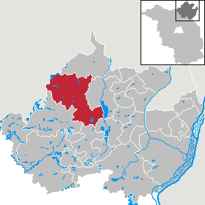
| Location of the municipality of Nordwestuckermark in the Uckermark district | ||
  |
||


Nordwestuckermark is an office-free municipality in the district Uckermark in Brandenburg (Germany).
geography
The name of the Uckermark municipality precisely describes the location in the north-western part of the Uckermark. With 253 km², Nordwestuckermark is one of the 40 largest municipalities in Germany . The municipal area is therefore larger than the city of Frankfurt am Main or almost twice as large as Schwerin .
The area of the municipality located in the north of Brandenburg includes the Uckermark hills and lakes, which were shaped by the Ice Age. Large parts of the municipality of Nordwestuckermark are located in the Uckermärkische Seen Nature Park , which is directly adjacent to the Feldberger Seenlandschaft Nature Park in the neighboring Mecklenburg Lake District . Of the uckermärkischen lakes the five largest within the municipality are mentioned: Großer See , Dammsee , Großer Parmensee , Sternhagener See and Naugartener See . The community has extensive contiguous forest areas in the south in the Zerweliner Heide . The highest elevation at 129 m above sea level. NHN is located in the Kiecker nature reserve southwest of the Fürstenwerder district.
Community structure
The municipality of Nordwestuckermark has the following districts:
|
|
Other inhabited parts of the municipality and places to live in the municipality:
Parish parts
|
|
|
Living spaces
|
|
|
history
The municipality of Nordwestuckermark was formed on November 1, 2001 from the previously independent municipalities of Ferdinandshorst, Fürstenwerder, Gollmitz, Kraatz, Naugarten, Röpersdorf / Sternhagen, Schapow, Schönermark and Weggun ( Northwestuckermark Office ) and the Holzendorf municipality ( Prenzlau-Land Office ). At the same time, the office of Nordwestuckermark was dissolved and the municipality of Nordwestuckermark was made free.
The current districts of Nordwestuckermark (with the exception of Naugarten and Weggun) belonged to the Prenzlau district from 1817–1952 (until 1947 in the Prussian province of Brandenburg , 1947–1952 in the state of Brandenburg ). 1952–1993 they were part of the Prenzlau district (until 1990 in the GDR district of Neubrandenburg , 1990–1993 again in the state of Brandenburg). Weggun and Naugarten belonged to the Templin district from 1817 to 1952 and were also incorporated into the Prenzlau district in 1952.
Since the district reform in Brandenburg in 1993, the places have belonged to the Uckermark district .
Districts
- Ferdinandshorst: Ferdinandshorst was first mentioned in a document in 1825.
- Lindenhagen: In June 1944 a concentration camp was established, the Hindenburg camp complex as a satellite camp of the Ravensbrück concentration camp , in order to establish an SS command post nearby (Birkenhain). Until 1949 the community was called Hindenburg .
- Birkenhain: In this district, VEB Backkombinat Neubrandenburg built and maintained a company holiday camp , which was looked after by the Pasewalk bakery (GROPA).
Parish parts
- Arendsee: First documented mention with Dominus Johannes de Arnesse in 1289.
Incorporations
The reorganization of the municipality of Nordwestuckermark came into effect on November 1, 2001. Earlier incorporations are also listed.
| Former parish | date | annotation |
|---|---|---|
| Arendsee | December 1, 1997 | Merger with Parmen-Weggun to form Weggun |
| Beenz | May 1, 1998 | Incorporation to Gollmitz |
| Falkenhagen | December 31, 1997 | Incorporation to Holzendorf |
| Ferdinandshorst | November 1, 2001 | |
| Fürstenwerder | November 1, 2001 | |
| Gollmitz | November 1, 2001 | |
| Holzendorf | November 1, 2001 | |
| Kraatz | November 1, 2001 | |
| Kröchlendorff | 1st January 1968 | Incorporation to Gollmitz |
| Lindenhagen 1 | July 1, 1961 | Incorporation to Sternhagen |
| Naugarten | November 1, 2001 | |
| Parmen | July 1, 1965 | Merger with Weggun to form Parmen Weggun |
| Parmen Weggun | December 1, 1997 | Merger with Arendsee to Weggun |
| Rittgarten | April 1, 1979 | Incorporation after Schapow |
| Röpersdorf | December 1, 1997 | Merger with Sternhagen to Röpersdorf / Sternhagen |
| Röpersdorf / Sternhagen | November 1, 2001 | |
| Shapov | November 1, 2001 | |
| Schönermark | November 1, 2001 | |
| Sternhagen | December 1, 1997 | Merger with Röpersdorf to Röpersdorf / Sternhagen |
| Weggun | July 1, 1965 December 1, 1997 November 1, 2001 |
Amalgamation with Parmen to Parmen-Weggun, church planting through amalgamation with Arendsee |
| Zollchow | July 1, 1950 | Incorporation to Röpersdorf |
- footnote
1 Lindenhagen was called Hindenburg until September 30, 1949.
Population development
|
|
|
|
Territory of the respective year: as of December 31, from 2011 based on the 2011 census
politics
Community representation
The community council consists of 16 community representatives and the full-time mayor. The local election on May 26, 2019 resulted in the following distribution of seats:
| Party / group of voters | Seats |
|---|---|
| For life in the country | 5 |
| Supporters of the Northwest Volunteer Fire Brigade | 3 |
| SPD | 3 |
| CDU | 2 |
| Fresh wind | 2 |
| Alliance 90 / The Greens | 1 |
mayor
- 2001–2020: Sylvia Klingbeil
- since 2020: Roland Klatt
Klatt was elected in the mayoral election on March 15, 2020 with 56.2% of the valid votes for a term of eight years.
coat of arms
The coat of arms was approved on September 24, 2003.
Blazon : "In a golden shield, sprinkled with black grains of grain, a green compass rose with a green-black faceted 16-pointed star and a black directional sign pointing to the upper right corner."
The coat of arms was designed by the heraldist Frank Diemar .
Attractions
In the list of monuments in Northwestuckermark are the monuments entered in the list of monuments of the state of Brandenburg.
traffic
The federal highway 109 between Prenzlau and Templin runs through the southeast of the municipality, the B 198 between Prenzlau and Woldegk touches the municipality in the northeast (district Holzendorf). The state road L 25 (also between Prenzlau and Woldegk) crosses the municipality from northwest to east.
In the district town of Prenzlau to the east there is a rail connection. The Prenzlau – Strasburg railway with the Holzendorf stop was closed in 1995. The railway Templin Prenzlau with the breakpoints Beenz and large lock forest since 2000 out of service. The Templin-Fährkrug-Fürstenwerder railway line ( Weggun-Arendsee , Parmen , Fürstenwerder stops ) was dismantled in 1945 as a reparation payment to the Soviet Union .
Personalities
- Curt Heinrich Gottlieb von Arnim (1735–1800), Prussian colonel
- Albert von Schlippenbach (1800–1886), poet, died in Arendsee
- Hans Steffen (1865–1936), geographer, born in Fürstenwerder
- Wilhelm Wittbrodt (1878–1961), reform pedagogue and Esperantist, born in Arendsee
literature
- Lieselott Enders : Historical local lexicon for Brandenburg, Part VIII, Uckermark , Weimar 1986, ISBN 3-7400-0042-2 .
Web links
- Sternhagen in the RBB program Landschleicher on August 3, 2014
- Beenz in the RBB program Landschleicher on October 18, 2015
- Falkenhagen in the RBB program Landschleicher from January 1, 2017
Individual evidence
- ↑ Population in the State of Brandenburg according to municipalities, offices and municipalities not subject to official registration on December 31, 2019 (XLSX file; 223 KB) (updated official population figures) ( help on this ).
- ^ Website of the municipality of Nordwestuckermark
- ↑ Municipality of Nordwestuckermark on the service portal of the state administration
- ↑ a b c Formation of a new municipality in Northwestuckmark. Announcement of the Ministry of the Interior of September 14, 2001. Official Gazette for Brandenburg Common Ministerial Gazette for the State of Brandenburg, Volume 12, 2001, Number 44, Potsdam, October 30, 2001, p. 695 PDF
- ↑ Contribution to the statistics of the State Office for Data Processing and Statistics. Historical municipality register of the State of Brandenburg 1875 to 2005 7.15 pm District Uckermark PDF
- ↑ Historical municipality register of the state of Brandenburg 1875 to 2005. District Uckermark . Pp. 22-25
- ↑ Population in the state of Brandenburg from 1991 to 2017 according to independent cities, districts and municipalities , Table 7
- ^ Office for Statistics Berlin-Brandenburg (Ed.): Statistical report AI 7, A II 3, A III 3. Population development and population status in the state of Brandenburg (respective editions of the month of December)
- ^ Result of the local election on May 26, 2019
- ↑ Local elections October 26, 2003. Mayoral elections , p. 34
- ↑ Brandenburg Local Election Act, Section 74
- ↑ The school council becomes mayor of Northwestuckermark. In: Nordkurier , March 15, 2020.
- ↑ Coat of arms information on the service portal of the state administration of Brandenburg
Angermünde | Berkholz-Meyenburg | Boitzenburger Land | Brüssow | Carmzow-Wallmow | Casekow | Flieth-Stegelitz | Gartz (Oder) | Gerswalde | Göritz | Gramzow | Grünow | Hohenselchow-Groß Pinnow | Lychen | Mark Landin | Mescherin | Milmersdorf | Mittenwalde | Northwestuckermark | Oberuckersee | Passow | Pinnow | Prenzlau | Randow Valley | Schenkenberg | Schöneberg | Schönfeld | Schwedt / Oder | Tantow | Temmen-Ringenwalde | Templin | Uckerfelde | Upland | Zichow