
Berkholz-Meyenburg
| coat of arms | Germany map | |
|---|---|---|

|
Coordinates: 53 ° 3 ' N , 14 ° 14' E |
|
| Basic data | ||
| State : | Brandenburg | |
| County : | Uckermark | |
| Office : | Or catfish | |
| Height : | 25 m above sea level NHN | |
| Area : | 11.76 km 2 | |
| Residents: | 1245 (Dec. 31, 2019) | |
| Population density : | 106 inhabitants per km 2 | |
| Postal code : | 16306 | |
| Area code : | 03332 | |
| License plate : | UM, ANG, PZ, SDT, TP | |
| Community key : | 12 0 73 032 | |
| Office administration address: | Gutshof 1 16278 Pinnow |
|
| Website : | ||
| Mayor : | Gerd Regulator ( FDP ) | |
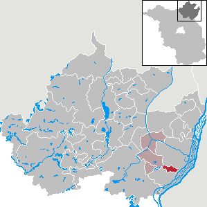
| Location of the community Berkholz-Meyenburg in the district of Uckermark | ||
  |
||

Berkholz-Meyenburg is a municipality in the southeast of the Uckermark district in Brandenburg (Germany). It is administered by the Oder-Welse office based in Pinnow .
geography
The municipality of Berkholz-Meyenburg is located in the eastern part of the Oder-Welse office, borders the municipality of Pinnow in the west, Schöneberg in the southwest and the industrial city of Schwedt / Oder in the east, south and north . The Hohensaaten-Friedrichsthaler Wasserstraße runs south of the municipality on the edge of the Lower Oder Valley National Park .
Community structure
Berkholz-Meyenburg consists of the inhabited districts of Berkholz and Meyenburg.
history
Berkholz and Meyenburg belonged to the Angermünde district in the Prussian province of Brandenburg since 1817 and to the Angermünde district in the GDR district of Frankfurt (Oder) from 1952 . On April 1, 1974, Berkholz and Meyenburg merged. The community has been in the Brandenburg district of Uckermark since 1993.
Berkholz
The village of Berkholz was first mentioned in a document in 1354 under the name "Bergholt" and named after the "Birkenhölz". The place is a foundation from the Ascanian colonization period. In the years 1354/55 Berkholz became Pomeranian . The fief of the village of Pflillipus Balkenberg was first listed by name in 1432. In 1481 ownership passed to the Counts of Hohenstein, and in 1492 to those of Stegelitz zu Criewen.
Meyenburg
The first evidence for Meyenburg (zur Miewenburgk) can be found in 1578. In 1652 the name Meydeburgk and 1661 Meyenburgk appeared. 1578 the Count of Hohenstein is mentioned. In 1648 the shepherd at Meyenburg restored the barren and desolate sheep farm. In 1653 there were three cottages, two of which were desolate. In 1840 the village and manor had 15 houses, in 1931 16.
Population development
| Berkholz | 1774 | 1801 | 1817 | 1840 | 1925 | 1939 | 1946 | 1964 | 1971 |
| Residents | 196 | 241 | 239 | 328 | 383 | 289 | 516 | 352 | 374 |
| Meyenburg | 1774 | 1801 | 1817 | 1840 | 1925 | 1939 | 1946 | 1964 | 1971 |
| Residents | 79 | 100 | 105 | 149 | 118 | 141 | 173 | 162 | 134 |
| Berkholz-Meyenburg | 1981 | 1990 | 2000 | 2005 | 2010 | 2011 | 2012 | 2013 | 2014 | 2015 | 2016 | 2017 | 2018 | 2019 |
| Residents | 379 | 340 | 1129 | 1221 | 1279 | 1279 | 1266 | 1268 | 1289 | 1257 | 1254 | 1226 | 1230 | 1245 |
Territory of the respective year, number of inhabitants: as of December 31 (from 1991), from 2011 based on the 2011 census
politics
Community representation
The community council of Berkholz-Meyenburg consists of 10 community representatives and the honorary mayor.
| Party / group of voters | Seats |
|---|---|
| FDP | 7th |
| CDU | 1 |
| AfD | 1 |
| Individual applicant Gerhard Dyrba | 1 |
(As of: local election on May 26, 2019 )
mayor
- since 1998: Gerd Regulator (FDP)
In the mayoral election on May 26, 2019, the regulator was elected with 100.0% of the valid votes for a further term of five years.
coat of arms
The coat of arms was approved on May 6, 2004.
Blazon : "Divided in the head of the shield by two points of green and gold, underneath, above a green mountain, two green birch leaves with two inflorescences turned diagonally."
Attractions

The church in the Berkholz part of the municipality (Kirchstrasse 6) is listed as an architectural monument in Brandenburg's state monument list. It was built after a fire in the old church in 1887. The furnishings and the bell also date from this year. The nave, however, was built using field stone blocks from the previous building, which dates from the 13th century. The church is characterized by a simple interior design, while the stained glass windows are striking. It is a single-nave brick church with a square tower in front on the west side.
Economy and Infrastructure
The crude oil tank farm for PCK Raffinerie GmbH in Schwedt / Oder is located between the Berkholz district and the Heinersdorf district of Schwedt . This is the end point of a 3,000 km long oil pipeline from Russia . A large industrial area of 20 hectares in the area of the Meyenburg part of the municipality is located in the south of the municipality. Various companies of local to regional importance are based in the village.
traffic
Berkholz-Meyenburg is located on state road L 284 between federal road 2 south of Pinnow and Schwedt.
In the neighboring municipality of Pinnow and in the city of Schwedt / Oder there are train stations on the Regional Express line RE 3 Schwedt - Berlin– Lutherstadt Wittenberg .
freetime and sports
- Bowling center
literature
- Lieselott Enders : Historical local lexicon for Brandenburg, Part VIII, Uckermark , Weimar 1986, ISBN 3-7400-0042-2
Web links
Individual evidence
- ↑ Population in the State of Brandenburg according to municipalities, offices and municipalities not subject to official registration on December 31, 2019 (XLSX file; 223 KB) (updated official population figures) ( help on this ).
- ^ Service portal of the state administration Brandenburg. Berkholz-Meyenburg community
- ↑ a b c History of Berkholz-Meyenburg
- ↑ Historical municipality register of the state of Brandenburg 1875 to 2005. District Uckermark . Pp. 14-17
- ↑ Population in the state of Brandenburg from 1991 to 2017 according to independent cities, districts and municipalities , Table 7
- ^ Office for Statistics Berlin-Brandenburg (Ed.): Statistical report AI 7, A II 3, A III 3. Population development and population status in the state of Brandenburg (respective editions of the month of December)
- ^ Result of the local election on May 26, 2019
- ↑ Results of the local elections in 1998 (mayoral elections) for the district of Uckermark ( Memento of the original from April 15, 2018 in the Internet Archive ) Info: The archive link was inserted automatically and has not yet been checked. Please check the original and archive link according to the instructions and then remove this notice.
- ↑ Brandenburg Local Election Act, Section 73 (1)
- ^ Result of the mayoral election on May 26, 2019
- ↑ Coat of arms information on the service portal of the state administration of Brandenburg
- ↑ List of monuments of the State of Brandenburg: District Uckermark (PDF) Brandenburg State Office for Monument Preservation and State Archaeological Museum
Angermünde | Berkholz-Meyenburg | Boitzenburger Land | Brüssow | Carmzow-Wallmow | Casekow | Flieth-Stegelitz | Gartz (Oder) | Gerswalde | Göritz | Gramzow | Grünow | Hohenselchow-Groß Pinnow | Lychen | Mark Landin | Mescherin | Milmersdorf | Mittenwalde | Northwestuckermark | Oberuckersee | Passow | Pinnow | Prenzlau | Randow Valley | Schenkenberg | Schöneberg | Schönfeld | Schwedt / Oder | Tantow | Temmen-Ringenwalde | Templin | Uckerfelde | Upland | Zichow