Gramzow
| coat of arms | Germany map | |
|---|---|---|

|
Coordinates: 53 ° 13 ' N , 14 ° 0' E |
|
| Basic data | ||
| State : | Brandenburg | |
| County : | Uckermark | |
| Office : | Gramzow | |
| Height : | 65 m above sea level NHN | |
| Area : | 66.26 km 2 | |
| Residents: | 1800 (Dec. 31, 2019) | |
| Population density : | 27 inhabitants per km 2 | |
| Postal code : | 17291 | |
| Area code : | 039861 | |
| License plate : | UM, ANG, PZ, SDT, TP | |
| Community key : | 12 0 73 225 | |
| LOCODE : | DE GZW | |
| Address of the municipal administration: |
Poststrasse 25 17291 Gramzow |
|
| Website : | ||
| Mayor : | Uwe Koch | |
| Location of the municipality of Gramzow in the Uckermark district | ||
The municipality of Gramzow belongs to the Uckermark district in northern Brandenburg and is about 13 km from the district town of Prenzlau . It is located in the metropolitan area of Szczecin . The administrative seat of the office of the same name is located in Gramzow .
geography
The village of Gramzow is located on the lakes Klostersee (also Haussee ) and Kantorsee . The Schulzensee is located in the village . To the south (on the B 198 to Angermünde) lies the Glambecksee . To the southwest of Gramzow (towards Melzow / Warnitz) are the Kuhseen ( Großer and Kleiner Kuhsee ). The bathing area at the Großer Kuhsee can be reached from Karlshof.
Community structure
Gramzow includes the districts of Gramzow, Lützlow , Meichow and Polßen as well as the residential areas extension, forest house, Karlshof, Koboltenhof, Neumeichow, Randowhöhe and Zehnebeck.
history
During excavations in preparation for the Baltic Sea pipeline connection line OPAL , a group of seven Slavic body graves from the first half of the 12th century was found near Neumeichow. The skeletons were examined by the anthropologist Bettina Jungklaus . The four adults and three children were all buried stretched out on their backs in an east-west orientation. Four of the dead had their heads to the east, the others to the west. A 45 to 50 year old woman had two temple rings in the head area as part of the late Slavic costume. The other graves were empty. The woman with the temple rings also had a large and a small stone on her head and a large stone on her feet. Such “fossils” have been known for a long time in late Slavic body graves. They are likely aimed at preventing the deceased from returning . In this woman, this could have been due to six osteomas of different sizes on the frontal bone. The largest was 13 mm in diameter and 5 mm high. These benign, slow-growing bone tumors usually do not cause pain. However, depending on their location and size, they are clearly visible, as is the case with the woman buried here. The position of the large osteoma directly on the forehead above the left eye marked the face in a distinctive way during his lifetime.
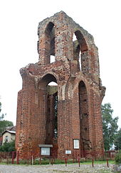
Gramzow was first mentioned in 1168 as villa Gramsowe (village), making it the “oldest documented place in the Uckermark ” ( Lieselott Enders ). In 1177/78 the Premonstratensian monastery Gramzow was founded. In 1714 the monastery church burned down. Only a part of the west wall has survived to this day. The ruined monastery is a landmark of Gramzow. Gramzow was first mentioned as a town in 1288, and since 1586 only as a town . The city ruler was the monastery, from 1542/43 the sovereign (elector).
In 1687 the French colony was founded. The Réfugiés received the monastery church, which burned down in 1714, for their services.
Administrative history
Gramzow, Lützlow, Meichow and Polßen belonged to the Angermünde district in the Prussian province of Brandenburg since 1817 . In 1952 Gramzow, Lützlow and Meichow were incorporated into the Prenzlau district in the GDR district of Neubrandenburg , and Polßen into the Angermünde district in the Frankfurt (Oder) district.
Since 1993 the places have been in the Brandenburg district of Uckermark. On December 31, 2001 Lützlow, Meichow and Polßen were incorporated into Gramzow.
Population development
|
|
|
|
|
Territory of the respective year, number of inhabitants: as of December 31 (from 1991), from 2011 based on the 2011 census
politics
Community representation
The community council of Gramzow consists of 12 community representatives and the honorary mayor. The local election on May 26, 2019 resulted in the following distribution of seats:
| Party / group of voters | Seats |
|---|---|
| CDU | 7th |
| Voting group community-oriented local politics | 4th |
| Single applicant Frank Gartzke | 1 |
mayor
- 1998–2003: Klaus Brandt (SPD)
- 2003–2016: Karl Heimann (CDU)
- since 2016: Uwe Koch (CDU)
Koch was elected in the mayoral election on May 26, 2019 with 57.8% of the valid votes for a further term of five years.
coat of arms
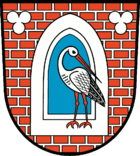
The coat of arms was approved on January 26, 2000.
Blazon : "In a silver jointed red brick wall an ogival, silver-framed blue window, with two silver three-passports at the top, inside a standing, defying red-armored stork in natural colors."
Attractions
The list of monuments in Gramzow includes the monuments entered in the list of monuments of the state of Brandenburg.
- Railway museum with the Gramzower Museumseisenbahn ( Brandenburg Museum for small and private railways at the former station)
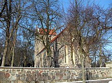
- The Church of St. Marien is a stately early Gothic stone church.
- A remnant of the former Gothic brick monastery church has been preserved from the Gramzow Monastery, suggesting an unusual, original building.
traffic
Gramzow is on the B 198 federal highway between Prenzlau and Angermünde . The B 166 runs between the Uckermark and Schwedt junction across the municipality, but has no connection to the town. The closest motorway junction is Gramzow on the A 11 Berlin – Stettin.
In 1906 the Schönermark – Damme district railway with the Gramzow train station and the Lützlow stop was inaugurated. In 1979 the section to Schönermark and in 1995 that to Damme were closed. On the stretch between Gramzow and Damme and between Damme and Eickstedt, the Gramzow Railway Museum now operates its own route. The starting point is the museum in Gramzow.
Personalities
Sons and daughters of the church
- Bernhard Kohlreif (1605–1646), rector of the grammar school for the gray monastery in Berlin
- Franz Theremin (1780–1846), Protestant theologian and poet
- Bernhard von Schkopp (1817–1904), Prussian infantry general , born in Poland
- Anna Karbe (1852–1875), song and local poet from Brandenburg
- Hermann Remané (1864–1932), electrical engineer and inventor
- Paul Hellmann (1889–1964), captain of the blockade breaker Osorno , the only knight's cross in the German merchant navy in World War II, was born in Zehnebeck
- Annegret Hahn (* 1951), director and theater manager
Personalities associated with Gramzow
- Herbert Brumm (pseudonym Harry Bär) (1909–1985), writer and photographer, lived in Gramzow
- Curt-Jürgen Heinemann-Grüder (1920–2010), Protestant pastor and superintendent in Gramzow
- Walter Bredendiek (1926–1984), Protestant theologian and functionary of the GDR CDU, grew up in Gramzow and worked there for several years
literature
- Lieselott Enders : Historical local lexicon for Brandenburg, Part VIII, Uckermark , Weimar 1986, ISBN 3-7400-0042-2
Web links
Individual evidence
- ↑ Population in the State of Brandenburg according to municipalities, offices and municipalities not subject to official registration on December 31, 2019 (XLSX file; 223 KB) (updated official population figures) ( help on this ).
- ^ Service portal of the state administration Brandenburg. Gramzow community
- ^ Project Neumeichow, Late Slavic Graves. In: anthropologie-jungklaus.de. Retrieved June 4, 2017 .
- ↑ Bettina Jungklaus: Special burials from May 10-15. Century in Brandenburg from an anthropological point of view . In: Ruth Struwe , Johan Callmer (Ed.): Ethnographic-Archaeological Journal . tape 50 , no. 1-2 . Verlag Beier & Beran , Langenweißbach 2009, p. 197-214 .
- ↑ Thilo Stapelfeldt, Bettina Jungklaus: Prevented from returning. Slavic graves with special burials near Neumeichow, district of Uckermark . In: Archeology in Berlin and Brandenburg . Konrad Theiss Verlag , 2008, ISSN 0948-311X , p. 72-74 .
- ↑ Thilo Stapelfeldt, Bettina Jungklaus: The fear of the woman . In: Archeology in Germany . tape 3 , 2010, ISSN 0176-8522 , p. 40-41 .
- ↑ Franz Winter: The Premonstratensians of the 12th Century and their Importance for Northeastern Germany. Berlin 1865, pp. 210-212.
- ↑ StBA: Changes in the municipalities in Germany, see 2001
- ↑ Historical municipality register of the state of Brandenburg 1875 to 2005. District Uckermark . Pp. 18-21
- ↑ Population in the state of Brandenburg from 1991 to 2017 according to independent cities, districts and municipalities , Table 7
- ^ Office for Statistics Berlin-Brandenburg (Ed.): Statistical report AI 7, A II 3, A III 3. Population development and population status in the state of Brandenburg (respective editions of the month of December)
- ^ Result of the local election on May 26, 2019
- ↑ Results of the local elections in 1998 (mayoral elections) for the district of Uckermark ( Memento of the original from April 15, 2018 in the Internet Archive ) Info: The archive link was inserted automatically and has not yet been checked. Please check the original and archive link according to the instructions and then remove this notice.
- ↑ Local elections October 26, 2003. Mayoral elections , p. 34
- ^ Election thriller in the municipal council Gramzow
- ↑ Brandenburg Local Election Act, Section 73 (1)
- ^ Result of the mayoral election on May 26, 2019
- ↑ Coat of arms information on the service portal of the state administration of Brandenburg


