
Boitzenburger Land
| coat of arms | Germany map | |
|---|---|---|

|
Coordinates: 53 ° 16 ' N , 13 ° 35' E |
|
| Basic data | ||
| State : | Brandenburg | |
| County : | Uckermark | |
| Height : | 90 m above sea level NHN | |
| Area : | 217.35 km 2 | |
| Residents: | 3089 (Dec. 31, 2019) | |
| Population density : | 14 inhabitants per km 2 | |
| Postal code : | 17268 | |
| Primaries : | 039884, 039885, 039889 | |
| License plate : | UM, ANG, PZ, SDT, TP | |
| Community key : | 12 0 73 069 | |
| Address of the municipal administration: |
Templiner Strasse 17 17268 Boitzenburger Land |
|
| Website : | ||
| Mayor : | Frank Zimmermann (independent) | |
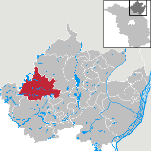
| Location of the municipality of Boitzenburger Land in the Uckermark district | ||
  |
||

Boitzenburger Land is an office-free municipality in the Uckermark district in the country Brandenburg (Germany). It is one of the 100 largest municipalities in Germany .
geography
The municipality in the north-east of Brandenburg encompasses the glacial hill and lake landscape of the western Uckermark . Large parts of the Boitzenburger Land municipality are located in the Uckermärkische Seen nature reserve . Of the Uckermark lakes , the five largest within the municipality are mentioned: Kuhzer See , Trebbowsee , Haussee, Großer Küstriner See and Krewitzsee . The community is surrounded in the northeast ( Zerweliner Heide ) and in the southwest ( Große Warthesche Heide ) by extensive, contiguous forest areas. In the northwest, the Mecklenburg district of Mecklenburg Lake District borders on the municipality of Boitzenburger Land. Neighboring communities in the Uckermark district are Nordwestuckermark , Gerswalde , Mittenwalde (Uckermark) , Templin and Lychen .
Community structure

The districts belong to the municipality
|
as well as the living spaces
|
|
|
history
Boitzenburg district
13th to 15th centuries

Today's Boitzenburg district grew out of originally two settlements. There was once the village of Boitzenburg, which was called Marienfließ as early as 1269. In the land book of Mark Brandenburg of 1375 it stood separately next to the spots Boitzenburg. It was probably roughly in the area of today's market town . The town of Boitzenburg, on the other hand, was on the Marienberg, with the Marienkirche located on the top. In 1215 it was first mentioned in a document in the spelling "Bozineburc". A mill was also mentioned in 1375 near the town. In 1403 both the village and the spots Boitzenburg belonged to the Boitzenburg monastery .
The foundation of the monastery went back to the year 1269, when it was donated by the knight Heinrich von Stegelitz . In 1271, Gerhard von Boyceneburg , probably the castle's lender , left ten Hufen in Boitzenburg to the monastery. Boitzenburg Castle was first mentioned in a document in 1276 as a castle complex . That year Dietrich von Kerkow was the liege- bearer of the castle and ten villages in the area. Since 1337 the margrave was apparently the owner of the castle, which was followed by the von Lochen family . Among the bailiffs were a certain from Lyne and one from Musheym . In 1375 only five villages belonged to Boitzenburg Castle: the little town of Boitzenburg, the villages of Krewitz, Zervelin, Wichmannsdorf and Mittenwalde. There are also numerous lakes. In 1299 the village of Brüsenwalde was part of the original equipment of the Himmelpfort monastery of the Cistercian monks .
Eventually the Boitzenburg rule came into the possession of Johann Herr zu Cotbus , who was temporarily the representative of Emperor Sigismund in the Mark. This was followed by the names of Holtzendorff , Lippolt von Bredow - the governor of the Mittelmark with his brothers - and finally Lüdeke von Maltzahn . In 1398 Boitzenburg came into Mecklenburg possession. In 1415 Boitzenburg and Zehdenick came to Brandenburg. In 1416 Boitzenburg was again in possession of a von Bredow before it came into the possession of the knight von Hase .
The von Arnim family , who later played a central role in the rule from the 16th century, received the castle and the bailiwick for the first time on January 29, 1429. In this way the margrave paid off debts he had made with the brothers Hans and Jaspar von Arnim. In 1439 Hans von Arnim was commissioned to undertake structural measures and repair the curtain walls . Kröchlendorff acquired this. As early as 1433, the brothers received the town of Strasburg with three villages, including Neuensund . In 1438, Hans was enfeoffed with Zehdenick Castle, later also with Sperrenwalde, as well as the city and Biesenthal Castle . Finally the bailiwicks Lychen and Woldegk came under his protection.
In 1448 von Cunersdorf , who later became bailiff of Neumark , became bailiff of Boitzenburg.
In 1454, the councilors of Elector Friedrich II of Brandenburg , named Hans von Bredow and Lüdeke von Arnim Boitzenburg, were sold by him. Lüdeke was already a pawnbroker of Angermünde (castle, town and office). The castle and office of Boitzenburg passed from the Bredows to the von Waldow and from these to the Uckermark captain von Hahn .
Finally, Henning von Arnim got Boitzenburg Castle in 1486, with taxes from Prenzlau , Strasburg and Templin, the bailiwick and town of Lychen, as well as the bailiwick in the Uckerlande . Henning was already the owner of half of the castle and town of Biesenthal and of Gerswalde. His sons were supposed to restore the dilapidated castle by margravial order. The names of Krummensee and Alvensleben followed , before the Arnims ruled Boitzenburg without interruption from 1528 to 1945.
16th to 18th century

In 1528, Elector Joachim I exchanged Boitzenburg Castle for Zehdenick Castle, which had previously been bought by Hans von Arnim, the governor of the Uckermark. At that time the following localities belonged to Boitzenburg Castle due to various taxes and services: Beenz, Berkholz, Boitzenburg (village and town), Bröddin, Hardenbeck, Haßleben, Klaushagen, Klosterwalde, Krewitz (wüst), Kuhz, Küstrinchen, Mahlendorf, Mechow, Niegelsdorf (wüst), Rosenow, Rutenberg, Sovow, Thomsdorf, Neu- u. Old Thymen, Warthe, Weggun and Zervelin (desolate). In addition, many lakes, logging and hunting rights, as well as money and grain leases from other places belonged to it. Hans von Arnim also bought properties in Kröchlendorff and Wichmannsdorf as well as the town of Petznick. When the Boitzenburg monastery was secularized in 1539 , Hans was able to make the most important acquisition, buying all of the goods of the monastery from Elector Joachim II .
.jpg)
Hans was succeeded by his son Bernd von Arnim as owner of the Boitzenburg estate. In 1570 there were a Schulz, a Kruger, four farmers and eight Kossäts in the village of Boitzenburg . Even in the 17th century, a distinction was made between the village and town of Boitzenburg. Bernd was followed by his second son Hans Georg von Arnim (1581–1641), often also called Johann Georg, who had to bring his country through the Thirty Years' War . He had studied at the universities of Frankfurt (Oder) , Leipzig and Rostock , fought in the Swedish army against Russia from 1613, then on the side of Wallenstein and rose as a general in the imperial army to field marshal .
In a report from 1687, almost 40 years after the Thirty Years' War, it is said that of the original 12 fishermen in the town of Boitzenburg only 2 were left. Boitzenburg's watermill was called the castle mill . The village of Boitzenburg (Marienfließ) had also suffered badly. There, of the six farms that had plowed 23 hooves, had become desolate due to the war, so that the von Arnim rule cultivated the land. The mill in the village was called Klostermühle . It still exists today and functions as a museum. The Marienkirche seems to have survived the Thirty Years' War well.
Georg Dietloff von Arnim (1679–1753) was the founder of the Boitzenburg Palace Library. For this he had a side wing of the castle built. The library was expanded by the following generations. Georg Dietloff's renovation also created a beautiful baroque complex. The town of Boitzenburg was also able to benefit from its construction work. So the road from the castle to the church was laid out through him. He renewed numerous churches in his patronage and he also donated sacrament implements. It was still important to repair the enormous damage caused by the Thirty Years' War in his rule. Villages had to be filled with new farmers and refurbished. Around 1750, the village and town of Boitzenburg were finally merged into a single market town. The population growth of the place stagnated up to the turn of the 19th century: The population had increased in 1801 with 663 inhabitants by only one inhabitant compared to 1750.
19th century to 1945

In 1801 there were 10 linen weavers, 10 bricklayers, 5 shoemakers, 6 tailors, 2 coopers, 3 carpenters and many individual craftsmen among the inhabitants of Boitzenburg. There were also two inns. Two junk markets took place every year. The farmers grew rye, barley, oats, peas, lentils, vetches, potatoes and buckwheat on their land.
The driveways of the castle at the front were designed by Count Adolf Heinrich von Arnim-Boitzenburg (1803–1868). His son Adolf (1832–1887) gave the castle the Renaissance look of the engraving by Merian .
Boitzenburg's population grew to 1045 by 1860, but shrank again to 776 by 1900. Boitzenburg had 888 inhabitants in 1925, but again only 725 in 1933, these figures including the estate and the Boitzenburg community.
Since the end of the First World War there has been a bison breeding in the zoo of the palace complex, which originates from the Renaissance. At the end of the Second World War , however , the bison , which was threatened with extinction in the 1920s, fell victim to poachers. The only descendants of the Boitzenburg bison breed live in Springe am Deister today (see Wisentgehege Springe ). The Boitzenburg forest even housed lesser spotted eagles . There were also several ospreys - and two sea eagle nests . Cranes and black storks also lived in the park, as well as large game .
In 1938, Boitzenburg Castle became the location for the socially critical satirical film Napoleon is to blame for everything by Curt Goetz . The film was banned by Propaganda Minister Goebbels in 1939 .
The last Arnim owner of Boitzenburg Castle was Joachim Dietlof von Arnim-Boitzenburg (1898–1972), who fled to the west with his family in 1945 shortly before the invasion of the Red Army . The Russian occupiers expropriated the count family in the same year without compensation. The Soviet soldiers carelessly packed the approx. 10,000 volumes in the palace library in crates and had them transported to Moscow. Since then, most of the holdings have been considered lost. Only a few specimens have since reappeared on winding paths.
1945 until today

As a result of the land reform in the Soviet occupation zone, the expropriated land was initially divided among landless farmers, agricultural workers and refugees , who later brought it into the agricultural production cooperatives (LPG). Most of the forest was nationalized.
In 1949 a fire partially destroyed the tower superstructures and the renaissance gable of the main palace from Count Adolf's time. However, the large roof could be restored.
Later the castle was used by the NVA as a rest home.
In the 1970s, the last Count of Boitzenburg and his wife died in exile. After the fall of the Wall, in 1994, their urns could be transferred to the Boitzenburg family grave of the Arnims.
On April 26, 2003, Boitzenburg Castle was opened to the public after extensive renovations began in 1999. It houses a hotel and a restaurant. The Marstall opposite is used as a creative center, farmers market and event area.
Boitzenburg (Uckermark) and Boitzenburger Land municipality
On July 20, 1992 (and July 27, 1992) the Minister of the Interior of Brandenburg gave his approval for the establishment of the Boitzenburg / Uckermark Office . August 1, 1992 was set as the date on which the office was established. The office was based in the municipality of Boitzenburg and initially consisted of ten municipalities in what was then the district of Templin :
- Berkholz
- Boitzenburg
- Beech grove
- Funkenhagen
- Hardenbeck
- Hate life
- Jacobshagen
- Klaushagen
- Warta
- Wichmannsdorf
On December 27, 2001, the Ministry of the Interior approved the merger of the municipalities of Berkholz, Boitzenburg, Buchenhain, Funkenhagen, Hardenbeck, Haßleben, Klaushagen, Jakobshagen, Warthe and Wichmannsdorf to form the new municipality of Boitzenburger Land on December 31, 2001. The Boitzenburg (Uckermark) office was dissolved at the same time.
The current districts of the community belonged to the Templin district from 1817–1952 (until 1947 in the Prussian province of Brandenburg , 1947–1952 in the state of Brandenburg ). 1952–1993 the places were part of the Templin district (until 1990 in the GDR district of Neubrandenburg , 1990–1993 again in the state of Brandenburg). Since the district reform in Brandenburg in 1993, they have belonged to the Uckermark district .
Population development
Boitzenburger Land municipality
|
|
|
|
Territory of the respective year, number of inhabitants: as of December 31, from 2011 based on the 2011 census
Boitzenburg district
|
|
|
Territory of the respective year
politics
Community representation
The municipal council of Boitzenburger Land consists of 16 municipal representatives and the full-time mayor. The local election on May 26, 2019 resulted in the following distribution of seats:
| Party / group of voters | Seats |
|---|---|
| Boitzenburger Land Free Electoral Association | 6th |
| CDU | 4th |
| The left | 3 |
| Alliance 90 / The Greens | 2 |
| Individual applicant Mathias Gärtner | 1 |
mayor
- 2003–2016: Bernhardt Rengert
- since 2016: Frank Zimmermann (independent)
Bernhardt Rengert was re-elected mayor in the runoff election on June 20, 2010 with 58.2% of the valid votes. He has been retired since June 30, 2016.
His successor Frank Zimmermann was elected in the mayoral election on December 4, 2016 with 71.6% of the valid votes for a term of eight years.
coat of arms
The coat of arms was approved on October 30, 2007.
Blazon : “Quartered and divided by a silver bar; Field 1: in blue a silver renaissance castle gable with two open windows and a quatrefoil above, fields 2 and 3: in red two silver bars, field 4: in blue an open silver pointed arch window. "
Fields 2 and 3 are borrowed from the coat of arms of the aristocratic von Arnim family, who have ruled the Boitzenburger Land for many years .
Attractions


The list of monuments in Boitzenburger Land includes the monuments entered in the list of monuments of the state of Brandenburg. Some ground monuments can also be found in the municipality, which are entered in the list of ground monuments in Boitzenburger Land .
Buildings
- Boitzenburg Castle
- Lenné Park with the Temple of Apollo in Boitzenburg
- Gräflicher Marstall, currently used as a restaurant, chocolate factory, show bakery and coffee roastery
- Gardener's house in the inner castle district, first mentioned in 1780, restored from 1993 to 2005
- Parish Church of St. Mary on the Mountain
- Boitzenburg monastery ruin (former Cistercian monastery)
- Theater ruin Boitzenburg monastery
- Chapel in Buchenhain-Mellenau
- Thomsdorf Church
- Boitzenburger Tiergarten (oldest oak)
- Engagement stone in the Tiergarten (huge boulder)
- Former Fährkrug – Fürstenwerder railway line , now the “Spur der Steine” cycle path, runs west of Boitzenburg through the municipality
- Hardenbecker Haussee , 120 ha in size, 6 km long, with a water hike connection to Boitzenburg via the Schumellensee and Küchenteich (boat rental at Boitzenburg Castle)
Museums and exhibitions
Boitzenburg monastery mill
The Klostermühle Boitzenburg is a historic water mill that functions as a museum. The mill is located on a stream that flows past the monastery ruins through the zoo towards Prenzlau and from there to the Baltic Sea.
The mill was first mentioned in 1271, when the Margraves Johann II, Otto IV and Conrad provided the monastery with the initial equipment with their foundation. When the monastery was dissolved during the Reformation, the monastery property and with it the Boitzenburg watermill soon passed into the ownership of the von Arnim family . The mill was not spared from destruction in the ongoing turmoil of the Middle Ages, but the mill building has existed in its current form since around 1752. In the following period there were numerous changes and modernizations inside. At the beginning of the 20th century it was already possible for the mill turbine to provide electrical light throughout Boitzenburg. After 1945 the mill was nationalized. Flour was still ground until 1959 and the LPG animal production had compound feed produced in it until 1978. The last miller of the mill, Willi Witte, took care of the maintenance of this mill technology.
The mill complex, which is now municipal property, has been open to the public as a museum since 1979. The museum miller and his journeymen offer tours during which the grinder is started, the bakery in the basement, the miller's apartment, the historic cartwright and the blacksmith's shop are visited and explained.
Boitzenburg Castle Collection
Whitsun 2008, a permanent exhibition called the Boitzenburg Castle Collection was opened in the historic cellar vault under the former library of Boitzenburg Castle . The exhibits shown here illustrate, on the one hand, some of the historical building findings from the multi-year renovation phase that the castle, which is now run as a hotel for children and young people, went through from 1999 to 2003. On the other hand, an attempt is made to bring the more than 400-year history of construction, ownership and use of the castle as one of the largest aristocratic castles in Brandenburg closer to the visitor. On weekends and public holidays, guided tours through the castle are offered, which conclude with a panoramic view from the platform of the Seiger tower.
Heimatstube and Galerie Klaushagen
In the district of Klaushagen there is a home parlor and gallery, which is housed in the listed town hall in the center of the village. Rural living and rural household items are presented in their rooms. From 1867 to 1963 the building served the Klaushagen residents as a village school and is therefore still often called the old school today. In the Heimatstube there is also a rich chronicle that provides information on more than 730 years of history of the village, the neighboring town of Lichtenhain and the Suhrhof residential area. In the large, former classroom of the old school , personal exhibitions by artists from the region take place at irregular intervals. A small exhibition with agricultural equipment in front of and in the outbuilding of the community center is freely accessible.
Warthe home parlor

The Warther Heimatstube is located in the former smithy on the central village green of the long street village. From 1885 to 1960 the village smithy was run by master blacksmiths Schmöker (father and son) before it was taken over by LPG in 1960, closed eleven years later and used as an additional classroom until the village school in Warthe closed in 1998.
The Heimatstube was inaugurated on the occasion of the 700th anniversary of the town in 1995. In addition to museum exhibits, the former forge also houses a small library. You can see evidence of village life and mementos from the Templin-Fährkrug-Fürstenwerder railway line , which also crossed the Warta. Only built between 1910 and 1912, this railway line was only used for passenger and freight traffic from 1913 to 1945. As early as June 1945, the complete dismantling of the tracks began as a reparation payment for the Soviet Union.
Craftsman's yard Thomsdorf
In the district of Thomsdorf there is an area with a ceramic and felt workshop and a stone oven. In addition to watching the pottery work, you can also make your own ceramic work in the ceramic workshop. The same applies to the felt workshop. Pizza and bread are baked in the stone oven. Attached to this is the “Klönstuw” farm café . In addition, there are exhibition rooms on the area where various artists present their works made of wood, ceramics, painting, wool, photography, etc.
Hardenbeck Museum School
In the Hardenbeck Museum School, two historical classrooms can be seen in addition to the teacher's room of a village school teacher and a room for special exhibitions and lectures. Over 100 years of village school history are being tried to bring back to life. One room shows the complete inventory of an imperial classroom from the slate with pencil and sponge to the teacher's cane. A second room shows a village school class from 70 years later. The museum school has an extensive fund of school and regional history in Hardenbeck and the Uckermark. The collection includes a textbook and a complete collection of primers.
Economy and Infrastructure
Companies
Many small and medium-sized businesses are based in the community. Uckermark-Fisch GmbH is based in Boitzenburg and has branches in Lychen and Templin, and Lichtenhain is located in the Lichtenhain district and sells apple products (owner Daisy von Arnim).
There are also several gastronomic establishments, for example in the Boitzenburg district “Restaurant Schloss Boitzenburg” , “Zur Klostermühle” , “Zumgrün Baum” . There are other restaurants in the districts of Berkholz, Buchenhain, Hardenbeck, Haßleben, Thomsdorf, Wichmannsdorf and Warthe.
In the holiday region, rich in forests and lakes, there is further development potential in the tourism sector. So are z. B. many holiday apartments available in the municipality.
traffic
The federal highway 109 between Templin and Prenzlau crosses the district of Haßleben. The state road L 15 between Lychen and Gollmitz crosses the municipality in a west-east direction, the L 24 connects Boitzenburg with the Pfingstberg motorway junction on the A 11 Berlin– Stettin . Templin can be reached via the L 217.
The Templin-Fährkrug-Fürstenwerder railway with the Warthe , Hardenbeck and Krewitz stops was dismantled in 1945 as a reparation payment to the Soviet Union . The Löwenberg – Prenzlau railway with the Haßleben station was shut down in 2000 .
education
The municipality of Boitzenburger Land has day-care centers in Boitzenburg, Haßleben, Hardenbeck and Wichmannsdorf. The only school in the community, the “Pushkin Elementary School” , is located in the Boitzenburg district. There are secondary schools both in Templin and in Prenzlau, both around 20 km from the Boitzenburg district.
societies
There is a diverse range of clubs in the Boitzenburg district:
|
|
|
Personalities
Sons and daughters of the church
- Hans Georg von Arnim-Boitzenburg (1583–1641), field marshal of the Electorate of Saxony
- Georg Abraham von Arnim (1651–1734), Prussian Field Marshal General
- Konstantin Decker (1810–1878), pianist, composer and music teacher, born in Fürstenau
- Adolf von Arnim-Boitzenburg (1832–1887), President of the Reichstag
- Herwart Fischer (1885–1938), forensic doctor and university professor
- Julius Starcke (1895–1945), sculptor, born in Stabeshöhe
- Joachim Dietlof von Arnim-Boitzenburg (1898–1972), last count at Boitzenburg Castle
- Helmut Christian Reiche alias Christian Ryke (1913–1993), lawyer and book author, born in Wichmannsdorf
- Sieghart von Arnim (* 1928), manager and non-fiction author, born in Arnimshain (today Buchenhain)
literature
- Benedykt Zientara: The agricultural crisis in the Uckermark in the 14th century . In: Feudal structure, feudal bourgeoisie and long-distance trade in late medieval Brandenburg . Introduction by Eckhard Müller-Mertens (= Hansischer Geschichtsverein [Hrsg.]: Treatises on commercial and social history . Volume VII). Verlag Hermann Böhlaus successor, Weimar 1967, DNB 456539689 , p. 221–396 (Polish: Kryzys agrarny w Marchii Wkrzańskiej w XIV wieku. Z badań nad Strukturą rolnictwa krajow nadbałtyckich . Warszawa 1961. Translated by Berthold Puchert).
- Hartmut Harnisch : The Boitzenburg rule. Studies on the development of the socio-economic structure of rural areas in the Mark Brandenburg from the 14th to the 19th century . With 3 maps in the appendix (= Friedrich Beck [Hrsg.]: Publications of the State Archives Potsdam . Volume 6). Hermann Böhlaus successor, Weimar 1968, DNB 456913947 .
- Werner Lippert: History of the 110 farming villages in the northern Uckermark. A contribution to the economic and social history of the Mark Brandenburg . Ed .: Gerd Heinrich . Böhlau Verlag, Cologne 1968, DNB 457441283 .
- Lieselott Enders (adaptation): Historical local dictionary for Brandenburg. Uckermark. With an overview map in the appendix (= Friedrich Beck [Hrsg.]: Historisches Ortslexikon für Brandenburg . Part VIII; Publications of the Potsdam State Archives . Volume 21). Hermann Böhlaus Successor, Weimar 1986, ISBN 3-7400-0042-2 (gives a 2-volume reprint from 2012).
- Winfried Schich , Dirk Schumann, Blandine Wittkopp : Brandenburg monastery book. Volume I . In: Heinz-Dieter Heimann , Klaus Neitmann , Winfried Schich and others (eds.): Brandenburgisches Klosterbuch. Handbook of the monasteries, pens and commander by the mid-16th century . 2 volumes (= Klaus Neitmann on behalf of the Brandenburg Historical Commission and in connection with the Brandenburg State Main Archive [Hrsg.]: Brandenburg Historical Studies . Volume 14). 2nd Edition. Be.Bra Wissenschaft Verlag, Berlin 2010, ISBN 978-3-937233-26-0 , Boitzenburg. Cistercian Sisters, S. 212-223 .
- Lieselott Enders: The Uckermark. History of a Kurmark landscape from the 12th to the 18th century (= Klaus Neitmann [Hrsg.]: Publications of the Brandenburg State Main Archives . Volume 28). 2nd, unchanged edition. Berliner Wissenschafts-Verlag, Berlin 2008, ISBN 978-3-8305-1490-9 .
Web links
- History of the Church of St. Mary on the Mountain
- Klaushagen in the RBB program Landschleicher on May 12, 2013
- Boitzenburg in the RBB broadcast Landschleicher on August 16, 2015
Individual evidence
- ↑ Population in the State of Brandenburg according to municipalities, offices and municipalities not subject to official registration on December 31, 2019 (XLSX file; 223 KB) (updated official population figures) ( help on this ).
- ^ Service portal of the state administration Brandenburg. Boitzenburger Land municipality
- ^ Heinrich Berghaus: Land book of the Mark Brandenburg and the Markgrafthum Nieder-Lausitz in the middle of the 19th century; or geographical-historical-statistical description of the province of Brandenburg . Volume 2, Brandenburg 1855, p. 324.
- ↑ a b c Castle history 4. Retrieved on August 27, 2013 .
- ↑ Castle of Passions. Retrieved August 27, 2013 .
- ↑ Boitzenburg Castle. Archived from the original on July 3, 2013 ; Retrieved August 27, 2013 .
- ↑ Formation of the offices of Boitzenburg / Uckermark, Bad Wilsnack / Weisen, Gerswalde and Pritzwalk-Land. Announcement of the Minister of the Interior of July 27, 1992. Official Gazette for Brandenburg - Joint Ministerial Gazette for the State of Brandenburg, Volume 3, Number 58, August 12, 1992, p. 1018/9.
- ^ Formation of the Boitzenburg / Uckermark office. Announcement of the Minister of the Interior of July 20, 1992. Official Gazette for Brandenburg - Joint Ministerial Gazette for the State of Brandenburg, Volume 3, Number 62, August 25, 1992, p. 1054.
- ^ Formation of a new municipality Boitzenburger Land Announcement of the Ministry of the Interior of December 11, 2001. Official Gazette for Brandenburg Common Ministerial Gazette for the State of Brandenburg, Volume 12, 2002, Number 52, Potsdam, December 27, 2001, p. 894 PDF
- ↑ Population in the state of Brandenburg from 1991 to 2017 according to independent cities, districts and municipalities , Table 7
- ^ Office for Statistics Berlin-Brandenburg (Ed.): Statistical report AI 7, A II 3, A III 3. Population development and population status in the state of Brandenburg (respective editions of the month of December)
- ↑ Historical municipality register of the state of Brandenburg 1875 to 2005. District Uckermark . Pp. 14-17
- ^ Result of the local election on May 26, 2019
- ↑ Local elections October 26, 2003. Mayoral elections , p. 34
- ↑ Mayor retired with immediate effect . In: Nordkurier , June 30, 2016
- ↑ Brandenburg Local Election Act, Section 74
- ^ Result of the mayoral election on December 4, 2016
- ↑ Coat of arms information on the service portal of the state administration of Brandenburg
- ↑ Boitzenburg monastery mill. Retrieved August 27, 2013 .
- ↑ Boitzenburg Castle Collection. Retrieved August 27, 2013 .
- ↑ Heimatstube and Galerie Klaushagen. Retrieved August 27, 2013 .
- ↑ Warthe home parlor. Retrieved August 27, 2013 .
- ↑ Craftsman's yard Thomsdorf. Retrieved August 27, 2013 .
- ↑ Hardenbeck Museum School. Retrieved August 27, 2013 .
- ^ Municipality of Boitzenburger Land - museums. Retrieved August 27, 2013 .
- ^ Municipality of Boitzenburger Land - Gastronomy Guide. Retrieved August 27, 2013 .
- ^ Municipality of Boitzenburger Land - list of accommodations. Retrieved August 27, 2013 .
- ^ Municipality of Boitzenburger Land - daycare centers. Retrieved August 27, 2013 .
- ^ Municipality of Boitzenburger Land - school directory. Retrieved August 27, 2013 .
- ^ Municipality of Boitzenburger Land - directory of associations. Retrieved August 27, 2013 .
Remarks
- ↑ The approval for the formation of the office was given twice (probably by mistake). In both publications the office is called Amt Boitzenburg / Uckermark . Later the spelling Boitzenburg (Uckermark) prevailed.
Angermünde | Berkholz-Meyenburg | Boitzenburger Land | Brüssow | Carmzow-Wallmow | Casekow | Flieth-Stegelitz | Gartz (Oder) | Gerswalde | Göritz | Gramzow | Grünow | Hohenselchow-Groß Pinnow | Lychen | Mark Landin | Mescherin | Milmersdorf | Mittenwalde | Northwestuckermark | Oberuckersee | Passow | Pinnow | Prenzlau | Randow Valley | Schenkenberg | Schöneberg | Schönfeld | Schwedt / Oder | Tantow | Temmen-Ringenwalde | Templin | Uckerfelde | Upland | Zichow