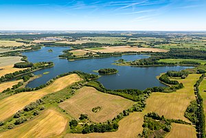
Kuhzer See
| Kuhzer See | ||
|---|---|---|

|
||
| Lake Kuhzer seen from the south-southwest | ||
| Geographical location | Uckermark , Brandenburg , Germany | |
| Tributaries | no | |
| Drain | none | |
| Islands | Kohlwerder | |
| Data | ||
| Coordinates | 53 ° 12 '58 " N , 13 ° 39' 6" E | |
|
|
||
| surface | 2.2 km² | |
| length | 3.2 km | |
| width | 2.9 km | |
| Maximum depth | 9 m | |
The Kuhzer See is a lake near Kuhz in the municipality of Boitzenburger Land in the Uckermark . He feeds a long streams to Havel inflow Templin waters . It is one of the Uckermark lakes and is located between Templin and Prenzlau , west of Haßleben .
The lake is about 220 hectares and up to nine meters deep. It has no direct connection to other lakes. The nearest lake is the Große Trebowsee, about a kilometer away . The Kuhzer See is divided into Schulzenort (northeast bay), Schwalbenlanke (south), Faule See, Mittenwald'sche Lanke (south), Prediger Lanke and Haßleben'sche Lanke (southeast).
In Haßleben there was the largest pig fattening facility in the GDR until the early 1990s. The facility, which was closed today, had a major impact on the area around Haßleben. The Kuhzer See, for example, fell over.

Individual evidence
- ↑ a b c Lake Kuhzer
- ↑ Environmental damage ( Memento from July 3, 2014 in the web archive archive.today )
