
Templiner waters
| Templiner waters | ||
 View from Templin upstream: in front left Bruchsee, full length Fährsee , behind left clay-yellow Labüskesee, at the upper edge of the picture Kölpinsee |
||
| Data | ||
| Water code | EN : 5814 | |
| location | Brandenburg , Germany | |
| River system | Elbe | |
| Drain over | Havel → Elbe → North Sea | |
| source | Ochsenbruch pumping station 53 ° 5 ′ 3 ″ N , 13 ° 40 ′ 51 ″ E |
|
| Source height | approx. 58 m above sea level NHN | |
| muzzle |
Havel 400 m below Schleuse Schorfheide Coordinates: 53 ° 4 '44 " N , 13 ° 21' 59" E 53 ° 4 '44 " N , 13 ° 21' 59" E |
|
| Mouth height | 45.8 m above sea level NHN | |
| Height difference | approx. 12.2 m
|
|
| Left tributaries | Lübbesee dig Schulz flow | |
| Right tributaries | Kuhz Lake dig Trebowsee dig | |
| Flowing lakes | Gotts See , Kölpinsee , Temnitzsee , Labüskesee , Fährsee , Templiner See , Röddelinsee , Gr. u. Kl. Lankensee, Kuhwallsee | |
| Templiner waters | |||||||||||||||||||||||||||||||||||||||||||||||||||||||||||||||||||||||||||||||||||||
|---|---|---|---|---|---|---|---|---|---|---|---|---|---|---|---|---|---|---|---|---|---|---|---|---|---|---|---|---|---|---|---|---|---|---|---|---|---|---|---|---|---|---|---|---|---|---|---|---|---|---|---|---|---|---|---|---|---|---|---|---|---|---|---|---|---|---|---|---|---|---|---|---|---|---|---|---|---|---|---|---|---|---|---|---|---|
 Templiner Canal |
|||||||||||||||||||||||||||||||||||||||||||||||||||||||||||||||||||||||||||||||||||||
| abbreviation | Part | ||||||||||||||||||||||||||||||||||||||||||||||||||||||||||||||||||||||||||||||||||||
| location |
|
||||||||||||||||||||||||||||||||||||||||||||||||||||||||||||||||||||||||||||||||||||
| length | 22.0 | ||||||||||||||||||||||||||||||||||||||||||||||||||||||||||||||||||||||||||||||||||||
| Built | 1894 to 1896 | ||||||||||||||||||||||||||||||||||||||||||||||||||||||||||||||||||||||||||||||||||||
| class | Inland waterway class I | ||||||||||||||||||||||||||||||||||||||||||||||||||||||||||||||||||||||||||||||||||||
| Beginning | at km 32.1 of the Upper Havel waterway below the Schorfheide lock | ||||||||||||||||||||||||||||||||||||||||||||||||||||||||||||||||||||||||||||||||||||
| The End | Zaarsee | ||||||||||||||||||||||||||||||||||||||||||||||||||||||||||||||||||||||||||||||||||||
| Descent structures | Can lock castle , lock Templin | ||||||||||||||||||||||||||||||||||||||||||||||||||||||||||||||||||||||||||||||||||||
| Responsible WSD | Eberswalde | ||||||||||||||||||||||||||||||||||||||||||||||||||||||||||||||||||||||||||||||||||||
|
course
|
|||||||||||||||||||||||||||||||||||||||||||||||||||||||||||||||||||||||||||||||||||||
The Templiner Gewässer is a left tributary of the Havel in the north of Brandenburg (water code number: 5814) of a good 30 km length. Of this, 21.25 km form the federal waterway of the same name (identifier: TlG), a branch of the Upper Havel waterway (OHW).
Waters
The main strand of the Templin waters and several of its tributaries form chains of lakes, which are largely included in the Uckermark Lakes , but also in the Schorfheide . Only 2.38 km above the confluence with the Havel flows from the left (in the direction of flow) its largest tributary, the 23 long Schulzenfließ . Between the two lies the long, multiply curved Lübbesee , whose shorter drainage path, the Ahrensdorf Canal to the Zaarsee, flows along the main line, the longer the Vietmannsdorfer Hammerfließ to the Schulzenfließ.
The catchment area of the Templiner waters borders in the north on that of the Lychener waters , in the south on that of the Döllnfließ , in the east on that of the Ucker and in the southeast on that of the catfish . In the west, the Havel tributary Kramsbeek with the Gallen-Beek flows between the Havel coming from the northwest and the area of the Templiner waters .
Federal waterway
The 22-kilometer federal waterway begins at km 32.1 of the Upper Havel waterway below the Schorfheide lock and ends in the Zaarsee near Templin . As the “Templin Canal”, it connects the lakes Zaarsee, Fährsee , Bruchsee and Templiner Stadtsee with the Röddelinsee and Großer Lankensee located further to the west . The difference in altitude to the Havel is compensated for by the Kannenburg lock between Großem Lankensee and Großem Kuhwallsee . The Templin waters belong to inland waterway class I and are maintained by the Eberswalde Waterways and Shipping Office .
Locks
history
The chain of lakes of the Templin waters is an old river course. The development of inland navigation began in 1745, quote: to facilitate the discharge of the products-Uckermark grain farming the waterway and was originally 35.5 km long and included above the Zaarsees large parts of today Lübbeseegrabens up into the Lübelowsee . It had five lock systems, the top lock was above the Melitzsee, one in Ahlimbsmühle between Großem Melitzsee and Lübbesee , the Ahrensnest lock between Lübbesee and Zaarsee, the Templin lock and the brickworks lock. The first lock Kannenburg was built fifty years later. After 1812 the decline of water transport began and by 1821 the locks in Ahlimbsmühle and above the Melitzsee were closed. The Ahrensnest lock was used for another fifty years. The brickworks lock was dismantled in the course of the expansion of the Templin Canal from 1894 to 1896 and the Templin lock was rebuilt. In 1906 the Kannenburg lock was rebuilt. Due to the poor condition of the Templin lock, it was shortened to a usable length of 25 meters in 1974 and consequently no longer usable for cargo shipping. It was finally closed in 1988 because of dilapidation, so that the Templin waters also ended for recreational shipping below the lock. In 2004 construction of the lock began, which was opened to traffic in September 2005.
The Kannenburg lock has been closed to all shipping since December 22, 2017 until further notice.

literature
- Hans-J. Uhlemann: Berlin and the Märkische waterways . transpress Verlag, Berlin, various years, ISBN 3-344-00115-9 .
- Writings of the Association for European Inland Shipping and Waterways e. V. various years. WESKA (Western European Shipping and Harbor Calendar), Binnenschifffahrts-Verlag, Duisburg-Ruhrort. OCLC 48960431
Individual evidence
- ↑ Which ditch in the Ochsenbruch is to be considered a source stream has not yet been determined.
- ↑ a b Hist. Measuring table sheets in the Brandenburg viewer
- ↑ Lengths of the main shipping lanes of the federal inland waterways. (PDF) (No longer available online.) BMVI , March 3, 2015, p. 24 , archived from the original on November 24, 2016 ; accessed on November 24, 2016 . Info: The archive link was inserted automatically and has not yet been checked. Please check the original and archive link according to the instructions and then remove this notice.
- ↑ Hans-J. Uhlemann: Berlin and the Märkische Wasserstraßen page 171
- ↑ News for inland shipping ELWIS accessed on January 14, 2020
Web links
photos
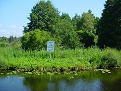
Branch from the Obere Havel waterway

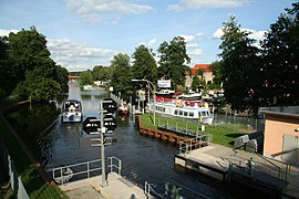
Kannenburg lock

Construction work on the Templin lock (2004)
Templin lock after renovation (2009)
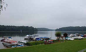
Templin city lake


