Lychener waters
| Lychener waters | ||
|
Great Warta lake |
||
| Data | ||
| Water code | EN : 5812 | |
| location | Brandenburg , Germany | |
| River system | Elbe | |
| Drain over | Havel → Elbe → North Sea | |
| source | Quellgrund on small Trebowsee 53 ° 12 '22 " N , 13 ° 35' 24" O |
|
| Source height | 82 m | |
| muzzle | in the Stolpsee der Havel Coordinates: 53 ° 10 ′ 30 ″ N , 13 ° 13 ′ 46 ″ E 53 ° 10 ′ 30 ″ N , 13 ° 13 ′ 46 ″ E |
|
| Mouth height | 51.8 m | |
| Height difference | 30.2 m | |
| Bottom slope | 0.89 ‰ | |
| length | 33.9 km | |
| Catchment area | 205.4 km² | |
| Flowing lakes | Großer Warthesee , Kleiner Warthesee , Rathenowsee , Großer Baberowsee , Großer Küstrinsee , Oberpfuhl , Lychener Stadtsee , Großer Lychensee , Himmelpforter Haussee | |
The Lychener Waters in the north of the state of Brandenburg is a tributary of the Havel and a branch of the Upper Havel Waterway (OHW). As a federal waterway it is 8.17 km long, but as a hydrographically defined watercourse it is 33.9 km. The portion of Himmelpforter Haussee upstream to Great Lychensee is Woblitz , the portion from the Lychener Oberpfuhl to Great Küstrinsee in old Ordnance Survey, Küstrinchener Bach ', which from this elongated lake to the Great Baberowse , Schleusengraben', above the Great Wartheland lake Beetgraben ' .
Hydrology
The Lychener waters have the water code number 5812. The surface catchment area has a nominal extension of 205 km². The actual catchment area is even larger than the nominal, as the Lychener waters receive water from the Feldberger lakes in two ways , which are counted as the source area of the river : There is a steady groundwater flow from the Dreetzsee into the Krüselinsee , whose water through the Mechowbach in the western end of the Großer Küstrinsee flows. There is also a surface runoff from the Carwitzer See into the lakes west of Boitzenburg , which are combined as water reservoirs , from which most of the water flows through the river , but a certain part is channeled through the Hausseebruchgraben into the Lychener waters above the Großer Küstrinsee.
| Federal waterway Lychener waters | |||||||||||||||||||||||||||||||||||||||||||||||||||||||||||||||||
|---|---|---|---|---|---|---|---|---|---|---|---|---|---|---|---|---|---|---|---|---|---|---|---|---|---|---|---|---|---|---|---|---|---|---|---|---|---|---|---|---|---|---|---|---|---|---|---|---|---|---|---|---|---|---|---|---|---|---|---|---|---|---|---|---|---|
|
Woblitz between Haussee and Großer Lychensee |
|||||||||||||||||||||||||||||||||||||||||||||||||||||||||||||||||
| abbreviation | LyG | ||||||||||||||||||||||||||||||||||||||||||||||||||||||||||||||||
| location |
|
||||||||||||||||||||||||||||||||||||||||||||||||||||||||||||||||
| length | 8.17 | ||||||||||||||||||||||||||||||||||||||||||||||||||||||||||||||||
| class | Inland waterway class I | ||||||||||||||||||||||||||||||||||||||||||||||||||||||||||||||||
| Beginning | Branch from the Stolpsee | ||||||||||||||||||||||||||||||||||||||||||||||||||||||||||||||||
| The End | Lychener Stadtsee | ||||||||||||||||||||||||||||||||||||||||||||||||||||||||||||||||
| Descent structures | Himmelpfort lock | ||||||||||||||||||||||||||||||||||||||||||||||||||||||||||||||||
| Used river | Woblitz | ||||||||||||||||||||||||||||||||||||||||||||||||||||||||||||||||
| Responsible WSD | Eberswalde | ||||||||||||||||||||||||||||||||||||||||||||||||||||||||||||||||
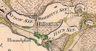
| Map from 1825 | |||||||||||||||||||||||||||||||||||||||||||||||||||||||||||||||||
|
course
|
|||||||||||||||||||||||||||||||||||||||||||||||||||||||||||||||||
Shipping route
The federal waterway begins at Himmelpfort , in the northeastern part of the Stolpsee , and ends in Lychen . It uses the course of the Woblitz to connect the Himmelpforter Haussee , the Großer Lychensee and the Lychener Stadtsee . The height difference to the Stolpsee is compensated by the lock Himmelpfort . The Lychener waters belong to inland waterway class I and are maintained by the Eberswalde Waterways and Shipping Office .
history
The Lychener waters branch off to the left at kilometer 55.00 from the Upper Havel waterway. According to depictions on old maps, they were already navigable in the 17th century. The forerunner of the 1976 reconstructed Himmelpfort lock was built in 1907. A first lock was built between 1879 and 1882 in the Schleusengraben at the old brewery . The original outflow of the house lake was the mill ditch, blocked by a weir and a mill with later electricity generation.
literature
- Hans-J. Uhlemann: Berlin and the Märkische waterways . transpress Verlag, Berlin, various years, ISBN 3-344-00115-9 .
- Writings of the Association for European Inland Shipping and Waterways e. V. various years. WESKA (Western European Shipping and Harbor Calendar), Binnenschifffahrts-Verlag, Duisburg-Ruhrort. OCLC 48960431
Individual evidence
- ↑ a b Hist. Measuring table sheets in the Brandenburg viewer
- ↑ a b Geoportal Brandenburg → data package gewnet25.zip → u. a. PDF: River directory, source data set gewnet25 Version 4.2
- ↑ https://geoportal.brandenburg.de/detailansichtdienst/render?url=https%3A%2F%2Fgeoportal.brandenburg.de%2Fgs-json%2Fxml%3Ffileid%3DB9D461F1-99A1-4C10-97B4-9C36C0BD40B9 → https: / /mlul.brandenburg.de/lua/gis/gewnet25.zip → therein u. a. PDF: List of rivers
- ↑ Lengths of the main shipping lanes of the federal inland waterways. (PDF) (No longer available online.) BMVI , March 3, 2015, p. 24 , archived from the original on November 24, 2016 ; Retrieved May 17, 2015 . Info: The archive link was inserted automatically and has not yet been checked. Please check the original and archive link according to the instructions and then remove this notice.


