
Carwitzer See
| Carwitzer See | ||
|---|---|---|

|
||
| Geographical location | District of Mecklenburg Lake District | |
| Tributaries | ( Schmaler Luzin →) Bäk. ( Wootzensee →) Floot → Zansen → | |
| Drain | • permanent: Dreetzsee → (groundwater flow) → Krüselinsee →→ Havel • temporarily: Isernpurt → Mellensee → Strom → Ucker |
|
| Places on the shore | Carwitz , Conow, Thomsdorf | |
| Data | ||
| Coordinates | 53 ° 18 '16 " N , 13 ° 27' 53" E | |
|
||
| Altitude above sea level | 84 m above sea level NHN | |
| surface | 3.95 km² | |
| volume | 38,520,000 m³ | |
| Maximum depth | 30 m | |
| Middle deep | 9.6 m | |

|
||

The Carwitzer See is a lake in Mecklenburg-Western Pomerania .
location
The lake is located in the east of Mecklenburg in the Mecklenburg Lake District in the Feldberger Seenlandschaft nature park and the municipality of the same name, southeast of its main town, Feldberg . In the south, the Carwitzer See borders the state of Brandenburg . The lake is part of the Havel catchment area . Its eastern bank is only 100 meters away from the natural watershed between the North and Baltic Seas .
Emergence
The Carwitzer See is a glacial tongue basin lake that was formed during the Pomeranian stage of the Vistula Ice Age .
structure
With an area of 3.95 km², the Carwitzer See is the largest lake in the Feldberg lake landscape. Its central part, about 2.6 x 2.3 kilometers, is relatively flat and has nine islands (the island names from west to east: Jägerwerder, Gänsewerder, Bohnenwerder, Steinwerder, Bollenwerder, Kohlwerder, Elswerder and two islands in front of Conow). To the north is the Zansen, about 4.2 kilometers long and over 40 meters deep . The Carwitzer See and the Zansen are considered in some sources as a limnological unit . In the south there is a bay that protrudes like a hook to the east, the so-called southern depth (30 m deep). The shorter Fallada and fishing bays protrude to the west . The village of Carwitz lies on them on a narrow land bridge that separates the Carwitzer See and the Zansen from the 6.5-kilometer-long Schmalen Luzin in the northwest . From the Schmalen Luzin water is supplied to the Carwitzer See via the "Bäk". The main runoff of the Carwitzer See takes place via the so-called "neck" to the southwest, 2 kilometer long Dreetzsee. From here the water flows underground through ribbon springs to the Krüselinsee and then over the Küstriner Bach towards Lychener Seen and on to the Havel .
With the Isernpurt, the lake has an artificial runoff into the Mellensee and thus to the Baltic Sea. This was built from 1575 to 1578 to compensate for high water levels, which can occur during heavy rainfall. The Isernpurt falls dry at water levels of around one meter below normal . The name Isernpurt for Iron Gate goes back to a so-called weir that was once equipped with iron fuses.
The bank on the northern part consists of meadow and fallow land, which is about 100 m above sea level. NHN rises, the ends of the bays and the two peninsulas in the south of the lake are relatively flat. The Conower Werder nature reserve is located on the Conower Werder, the eastern peninsula .
use
The lake is used for recreational purposes and for fishing. A campsite with a small swimming area is located on the northeastern bank near the Conow village. There is also a campsite with a swimming area on the west bank. There are other bathing spots on the Bohnenwerder. The practice of diving is only permitted in designated areas and driving on the lake with motor boats is prohibited.
fauna
Common fish species are burbot , bleak , carp , catfish , lead , pike , rudd , tench , eel , ruff , crucian carp , river perch , roach , three-spined stickleback and bream . Brown lamprey , rainbow trout , dwarf catfish , gudgeon , grass carp , silver carp and pikeperch are rare .
photos
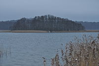
View of the eastern part of the Carwitzer See with the island of Elswerder

Boat huts on the Conower Ufer


See also
Web links
swell
- Topographic map 1: 100 000: C 2746 Prenzlau (State Survey Office Mecklenburg-Western Pomerania)
- ^ Gerhard Schlimpert , Reinhard E. Fischer : Die Gewässernamen Brandenburgs , Böhlau, Weimar 1996, ISBN 3-7400-1001-0 , p. 64