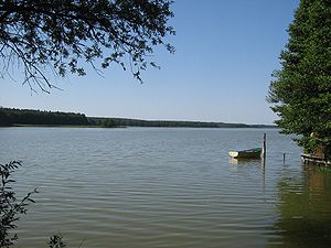
Useriner lake
| Useriner lake | ||
|---|---|---|

|
||
| Useriner lake | ||
| Geographical location | District of Mecklenburg Lake District | |
| Tributaries | Havel | |
| Drain | Havel | |
| Places on the shore | User | |
| Data | ||
| Coordinates | 53 ° 20 ′ 28 " N , 12 ° 58 ′ 10" E | |
|
|
||
| Altitude above sea level | 59.4 m above sea level NHN | |
| surface | 3.78 km² | |
| Maximum depth | approx. 10 meters | |
The Useriner See is part of the Mecklenburg Lake District and is traversed by the Havel . The lake is part of the Müritz National Park . It is located north of the Großer Labussee and is about 5.2 kilometers long and about 950 meters wide. It has an area of 365 hectares. The lake belongs to the upper Havel lakes and is connected to the large Mecklenburg lakes via the Obere Havel waterway . In the north there is a connection to the Kramssee and the Zierzsee . The approximately 33.4 hectare Zierzsee is strictly speaking just a bay in the Useriner See. The lake is only separated from it by the narrow Ziegenwinkel peninsula. On the east bank is the eponymous place Userin and in the south the small settlement Useriner Mühle. A little north of the settlement there is a small island in the lake. The east bank of the water is forested and the west bank at Userin is mostly used for agriculture. In the southern part there is a nudist campsite near Zwenzow .
