
Teterower See
| Teterower See | ||
|---|---|---|
-18-07-2008-048b.jpg)
|
||
| View from the Burgwallinsel on the Teterower See, in the middle of the picture the peninsula "Kleiner Bröken" | ||
| Geographical location | Rostock district | |
| Tributaries | Small peene and several streams | |
| Drain | Teterower Peene | |
| Places on the shore | Teterow | |
| Data | ||
| Coordinates | 53 ° 47 '29 " N , 12 ° 36' 28" E | |
|
||
| Altitude above sea level | 2.4 m above sea level NHN | |
| surface | 3.36 km² | |
| length | 3.312 km | |
| width | 1.878 km | |
| volume | 13.57 million m³ | |
| scope | 15 km | |
| Maximum depth | 10.7 m | |
| Middle deep | 4.0 m | |
| PH value | 9.1 | |
| Catchment area | 112.6 km² | |
|
particularities |
More than 90% of the lake bed is below sea level |
|

The Teterower See in Mecklenburg-Western Pomerania is located in the Rostock district in central Mecklenburg in a meadow and pasture landscape in the Mecklenburg Switzerland and Kummerower See Nature Park .
Location in the water network
The Teterower See lies in the course of the Teterower Peene, a source river of the Peene , which is called Kleine Peene above the lake . Today it leaves the lake as the (Teterower) Canal , which after 4.1 km joins the smaller Peene (without name affix) to the (Teterower) Peene , which finally flows into the Kummerower See as the ( Neukalener ) Peene Canal .
Geographical shape
The lake, northeast of Teterow , is around 3.3 kilometers long, 1.9 kilometers wide and has an average depth of four meters. The shoreline is strongly structured, especially in the southern part (islands Burgwall and the Sauerwerder). The lake becomes wider and shallower from south to northeast.
Parts of the western shore zone including the Sauerwerder and the Schnakenlang peninsula are in the Binsenbrink nature reserve .
history
The elongated castle wall island is located in the lake . There was a larger fortification on the island, which can still be seen today by the walls. After archaeological investigations in the 1950s, a tribal center of the Zirzipans of the island could be assigned.
tourism
The Teterower See is a good sailing area for dinghies and sailing cutters .
There are bathing opportunities on the southwest bank, on the Burgwallinsel and in the Teterow district of Teschow.
The excursion boat Regulus , a historic motor launch , operates on the lake . This ship was built in Hamburg in 1910 and initially used on the Müritz . In 1930 the Regulus was sold to Teterow and made excursions on the Teterower See until 1939. Launched during World War II , it was sunk in 1945. In 1999 her wreck was found in the lake, recovered and subsequently restored to working order. The ship veteran has been back on the road since 2001.
There are docks for the Regulus at Naturbad Teterow, on Burgwallinsel and in Teschow.
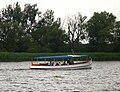
Barge “Regulus” from 1910, which has been used as a ferry since 2001

View of the Burgwallinsel

Playground and reconstructed Slavic outer bailey on Burgwallinsel


