Burgwallinsel (Teterower See)
| Burgwallinsel | ||
|---|---|---|
| View from the ferry terminal to the Burgwallinsel | ||
| Waters | Teterower See | |
| Geographical location | 53 ° 47 '34 " N , 12 ° 35' 56" E | |
|
|
||
| length | 1 km | |
| width | 190 m | |
| surface | 26 ha | |
| Residents | uninhabited | |
The Burgwallinsel is an elongated island in the Teterower See .
The castle wall island during the Slav period
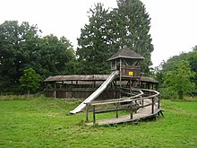
The special thing about it is that there was a dense settlement here in the Slavic era . There was a larger fortification on the island, which can still be seen today by the walls. After archaeological investigations in the 1950s, one could clearly see a tribal center of the Zirzipans here. The complex consists of a smaller main castle, which is only protected from one side by a bailey. The unsecured sides of the main castle are naturally protected by water. However, the entire island area is only used very little by the Slavic castle. It is located at the northern end of the island.
The bridge
At the other end of the island was the connecting bridge to the mainland. According to investigations, it must have been about 750 meters long. This makes it one of the longest known bridges from the Slav period. Building it must have taken a certain amount of time and is a masterpiece in bridge building .
The ramparts
In the foreground of the castle there were certainly also individual houses, perhaps cattle and horses were kept here. Whether there was a cult hall in the complex could neither be proven nor refuted. But it can be assumed that all of the larger Slavic castles had places of worship where the pagan gods were worshiped. You could also find your own ceramic style in the complex. There was certainly a connection between the front and the main castle. However, a gate in the main castle that faced the lake and could only be reached by boats could be clearly identified. The inner area of the relatively small main castle is 0.6 hectares. The wall is very well preserved today and almost 6 meters high. The complex must have made a great impression during the Slav period. At the time, the wall alone was 9 to 10 meters high. In addition, there was an oak palisade wall on the top of the rampart, another 4 to 5 meters high. The total height was therefore about 13 to 15 meters. In the interior of the main castle, the tribal prince and the tribal crew certainly lived. The craftsmen worked in the outer bailey, and sometimes they held markets directly on the island. In the complex, which has existed since the 8th century, one can certainly see the function of an old Slavic refuge. There were certainly many small Slavic villages around the lake. The plant existed in Mecklenburg-Western Pomerania until the end of the Slav period .
Burgwallinsel today
Today the castle wall island can be reached via a cable ferry at the southern end of the island, as well as with the barge Regulus . The center of attraction on the Burgwallinsel are the remains of the ramparts, the nature observation points and the Wendenkrug restaurant.
Web links
Individual evidence
- ^ [1] Burgwallinsel Teterow in the KLEKs with photos
- ↑ Reconstruction of the Burgwallinsel (picture) ( Memento from July 1, 2012 in the web archive archive.today )


