
schweriner Lake
| schweriner Lake | ||
|---|---|---|

|
||
| View of the southeast area of the Schwerin Inner Lake | ||
| GKZ | DE: 59281 (outer lake) , DE: 59283 (inner lake) |
|
| Geographical location | West Mecklenburg , Germany | |
| Tributaries | Burgsee , canals and ditches from Heidensee , Ziegelsee , Faulem See | |
| Drain | Sturgeon , Wallensteingraben | |
| Places on the shore | Schwerin | |
| Data | ||
| Coordinates | 53 ° 40 ′ 39 " N , 11 ° 27 ′ 42" E | |
|
||
| Altitude above sea level | 37.8 m above sea level NHN | |
| surface | 61.54 km² | |
| volume | 787.0 million m³ | |
| Maximum depth | 52.4 m | |
| Middle deep | 12.8 m | |
| PH value | 8.5-8.7 | |
| Catchment area | 414 km² | |

|
||

The Schweriner See is a lake in western Mecklenburg between Schwerin and Hohen Viecheln . Geomorphologically it can be described as the Glacier Tongue Lake of the Vistula Ice Age and belongs to the Mecklenburg Lake District landscape .
description
The lake is 24.8 kilometers long and up to six kilometers wide with an area of 61.54 km². This makes it the second largest north German lake after the Müritz and the fourth largest German lake . The average level is 37.8 m above sea level. NHN .
The Schweriner See is surrounded by smaller lakes and flows south through the Stör and Stör Canal to the Elde and on to the Elbe into the North Sea . To the north there is a connection to Wismar through the Wallenstein Graben , which can be navigated by experienced paddlers. The lake lies to the west and south of the North Sea-Baltic Sea watershed . The outflow over the Wallensteingraben to the Lostener See was artificially created with a puncture of the area from 1531 under Duke Albrecht VII . The Lostener See already drained towards the Baltic Sea. The long-term mean flow rate over the Stör is 1.65 m³ / s and that over the Wallenstein Graben 0.68 m³ / s. The minimum discharge rates are set at 0.5 m³ / s (Stör) and 0.3 m³ / s (Wallensteingraben). The water level is regulated by a weir on the northern outflow and the lock in Banzkow along the Stör waterway.
The Schweriner See is divided in the middle by the Paulsdamm, which was completed in 1842, into an outer and inner lake. A navigable connection has been left open with the Paulsdamm Canal, which is spanned by a road bridge on Bundesstrasse 104 . In the outer lake are the islands of Lieps , Horst and Rethberg , in the inner lake the islands of Schlossinsel , Rabbitwerder and Ziegelwerder .
The entire Schweriner See is part of the federal waterway Stör-Wasserstraße of waterway class I under the jurisdiction of the waterways and shipping office Lauenburg .
Places, offices, districts
The following cities, municipalities, offices and districts are (listed clockwise from the southwest) around Lake Schwerin:
- Schwerin (regional capital of Mecklenburg-Western Pomerania)
- Seehof ( Amt Lützow-Lübstorf in the district of Northwest Mecklenburg )
- Lübstorf (Office Lützow-Lübstorf in the district of Northwest Mecklenburg)
- Zickhusen (Office Lützow-Lübstorf in the district of Northwest Mecklenburg)
- Bad Kleinen ( Amt Dorf Mecklenburg-Bad Kleinen in the district of Northwest Mecklenburg )
- Hohen Viecheln (Amt Dorf Mecklenburg-Bad Kleinen in the district of Northwest Mecklenburg)
- Dobin am See ( Crivitz Office in the Ludwigslust-Parchim district )
- Leezen (Crivitz Office in the Ludwigslust-Parchim district)
- Raben Steinfeld (Crivitz Office in the Ludwigslust-Parchim district)
nature
The Schwerin Lake, classified as mesotrophic since 2014 , whose phosphorus pollution has decreased by more than 90 percent since the construction of the Schwerin Süd sewage treatment plant in 1991, is important for the protection of species and biotopes and was therefore awarded a "Living Lake" award by the Global Nature Fund in 2015 . Sea eagles and ospreys are among the breeding birds in the area . Otters have been detected on many banks of the water as far as the Schwerin city area. Within the framework of the European Natura 2000 network of protected areas , Lake Schwerin was declared a European bird sanctuary (Schwerin Lakes). In addition to the Schwerin outer lake, other lakeshore sections ( Döpe , Wald bei Wiligrad, Ramper Moor, Wickendorfer Moor, Görslower Ufer, Reppin) have the protection status of an FFH area ( Fauna-Flora-Habitat Directive ).
Flora and fauna in the Schwerin lakes
The flora and fauna of the Schwerin lakes are very diverse, both above and below water. In the Inner Lake of Schwerin you can find the often represented, native river perch , but also the rainbow trout , which originally came from America . The Schwerin Inner Lake is not too different from the larger Schwerin Outer Lake. However, predatory fish are more common in the outer lake. These include pike , pikeperch , perch and eel . White fish dominate in all waters. The white fish include bream , rudd , roach , arbor and many more. The lake with the fewest fish is the Ostorfer See . Due to the poor water quality, the fish species have not yet managed to settle there in the larger population. The flora is also very well developed. It is important for the fish population. Predatory fish use water lily fields to find cover and to hunt for white fish, for which the water lily field is used to forage, because there are particularly high concentrations of insects, snails, algae and plankton. Otherwise the lakes are richly populated with waterweed, horn leaf, water fern and other aquatic plants.
Not only conservationists, but also anglers are interested in the fish fauna. These are specifically addressed with the promise that the Schwerin lake “has a lot to offer especially to predatory fish anglers”: “Pike, pikeperch, perch and eels in some of the largest sizes!” But even “non-coarse fish specialists” would “get their money's worth: Roach and bream without end as well as big carp and tench are to be caught. "
_2.png)
.jpg)
gallery
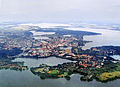
Aerial view of Schwerin and the surrounding lakes

The Schwerin Castle , which was built on a small private island in the Inner Lake

View of the Inner Lake from the tower of Schwerin Cathedral

Schwerin city center with cathedral, seen from the inner lake
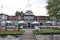
Schwerin sailing and yacht club

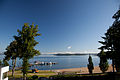
Beach of Zippendorf , a district of Schwerin
View of Rabbitwerder from the Zippendorf beach

Sunrise in front of the Marstall Peninsula (Schwerin)

Lookout tower on the Rabbitwerder , an island in the inner lake

Sunrise at the Insel Ziegelwerder

View from Rabbitwerder to Schwerin
The pole ditch between Innerensee and Heidensee
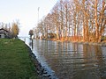
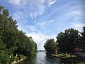
Paulsdammgraben between the Inner Lake and the Outer Lake
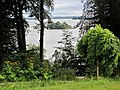
View from the park of Wiligrad Castle over the outer lake

Bathing area on the Bad Kleinener outer lake shore


.jpg)
.jpg)

.jpg)


Sea use vs. natural reserve

Every day from April to October, the White Fleet offers round trips on the west of the Inner Lake and neighboring smaller lakes in the Schwerin area. The maximum speed for ships and boats on the Schweriner See is set at 25 km / h, in the bank area a maximum of 8 km / h. Bathing areas marked with yellow buoys, as well as reed areas and other bird protection areas, may not be entered. This also applies to canoeists.

In 2015, the city of Schwerin published plans to promote the development of tourist infrastructures for boaters on Lake Schwerin. In 2015 there were 5,000 boats on the jetties of the Schweriner See. The new infrastructures are intended to increase public use by a further 322 spaces. 22 mooring areas were planned for the castle bay pier, including eleven public short-term berths and eleven berths for the restaurants located there. In addition, a possibility of mooring should be created for passenger ships that are traveling between Berlin and Schwerin, for example. At Wiligrad Castle on the west bank of the Outer Lake, passenger ships should again be able to and be allowed to moor, as was the case during the German Empire. Further berths were planned in Zippendorf, on Rabbitwerder, at the zoo, at the Schwerin-Mueß open-air museum , but also on the harbor promenade of the Ziegelinnensee. Supposedly there was the tourism According conveyors only for the Pochard "a slight excess of materiality" by the outgoing from the boat traffic disruptions.
The BUND Schwerin contradicts this point of view : The new construction of footbridges planned in many places with a corresponding expansion of boat traffic will inevitably lead to new routes for the boats and in many places to a further narrowing of the habitat of the water birds. In the meantime, the sum of the impairments did not allow any further burdens unless restrictions were made elsewhere. The Schwerin Administrative Court had confirmed the BUND's action against another investor in Schlossbucht. At this location, too, additional pollution from additional boat traffic is no longer acceptable for the ecosystem. According to the BUND, other new locations in the vicinity of the reed belts that still exist are questionable. Ultimately, more infrastructure leads to more disruption and damage to the still natural areas. The BUND is equally critical of the establishment and use of water ski trails, some of which are illegally used for jet ski trips. Particularly in the breeding season, these trips, as well as the trips to and from the water ski trails, led to disturbances and water pollution from waves and turbulence, to the danger of clutches and young birds, to the destruction of reeds and other plants and to the consequences of erosion on the bank.
See also
Web links
- City of Schwerin: Lake Tour Schwerin: Nature, nature conservation and lake data
- City of Schwerin: Spaces to experience nature on Lake Schwerin
- Tourism in Mecklenburg: Lake Schwerin
Individual evidence
- ↑ a b c d e Documentation of the condition and development of the most important lakes in Germany: Part 2 Mecklenburg-Western Pomerania (PDF; 3.5 MB)
- ↑ Lengths (in km) of the main shipping lanes (main routes and certain secondary routes) of the federal inland waterways ( memento of the original from January 21, 2016 in the Internet Archive ) Info: The archive link was inserted automatically and has not yet been checked. Please check the original and archive link according to the instructions and then remove this notice. , Federal Waterways and Shipping Administration
- ^ Friedrich Stuhr : The Elbe-Ostsee Canal between Dömitz and Wismar ( Memento from September 26, 2007 in the Internet Archive ) in year books of the Association for Mecklenburg History and Archeology. Vol. 64 (1899), p. 197
- ↑ The Elbe from the mouth of the Havel to the Geesthacht weir ( Memento from December 14, 2007 in the Internet Archive ) (PDF; 9.4 MB) in The Elbe and its catchment area , International Commission for the Protection of the Elbe, 2005
- ↑ Directory E, serial no. 35 der Chronik ( Memento of the original from July 22, 2016 in the Internet Archive ) Info: The archive link was inserted automatically and has not yet been checked. Please check the original and archive link according to the instructions and then remove this notice. , Federal Waterways and Shipping Administration
- ↑ Schweriner See - Lebendiger See 2015 . seen.de
- ^ Mecklenburg-Western Pomerania: The Schweriner See . fischundfang.de. Paul Parey magazine publisher
- ↑ State capital Schwerin: The Schweriner See
- ↑ Martina Wichor: New software calculates the effects on protected bird species - bird life can withstand additional boat traffic . 20th November 2015
Burgsee | Lazy Lake | Grimkesee | Heidensee | Great crucian | Lankower See | Medeweger See | Neumühler See | Ostorfer See | Pfaffenteich (pond) | Schwerin Lake | Ziegelsee