
Ziegelwerder
| Ziegelwerder | ||
|---|---|---|
 |
||
| Waters | schweriner Lake | |
| Geographical location | 53 ° 36 '56 " N , 11 ° 28' 57" E | |
|
||
| surface | 30 ha | |
 |
||

Ziegelwerder describes an inland lake island in the southern Schwerin Inner Lake in Mecklenburg-Western Pomerania and the nature reserve of the same name, which includes the island and a strip around it.
Ziegelwerder Island
The island has a size of 0.30 km². Like the neighboring island of Rabbitwerder to the northwest, Ziegelwerder was formed in the Frankfurt season of the Vistula Ice Age around 20,000 years ago and is part of a ridge that is largely under water. The core of the island consists of boulder clay . In the past clay was mined and lime was extracted for a brick factory on the island. This is where the name Ziegelwerder comes from. The island was almost free of trees in the 19th century due to its operation. The northern part is now private property, and until 1970 there were two farms in the northern part. To this day there is an inhabited farmstead where one person lives. In the north there are also riparian forests, a meadow orchard. In the meantime, forest has formed in the southern part, which cannot be entered . Due to the lowering of the water level, which is associated with the construction of the Stör Canal , beach ridges could form in the area of the island near the shore and alder forests could form due to siltation.
Ziegelwerder nature reserve
The island was placed under protection in 1990. The protected area includes the island and a 100 meter wide waterfront protection zone close to the shore.
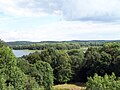
View of the west side of Ziegelwerder from Rabbitwerder


