Borgwallsee
| Borgwallsee | |
|---|---|

|
|
| The Borgwallsee seen from the Penniner Forst, towards Pütte / Stralsund | |
| Geographical location | Mecklenburg-Western Pomerania |
| Tributaries | Mühlengraben from Krummenhagener See , further ditches |
| Drain | Barthe , Mühlengraben to Pütter See |
| Location close to the shore | Stralsund , Negast |
| Data | |
| Coordinates | 54 ° 16 '24 " N , 13 ° 0' 28" E |
| Altitude above sea level | 13.2 m above sea level NHN |
| surface | 3.89 km² |
| length | 3.64 km |
| width | 1.78 km |
| volume | 9,200,000 m³ |
| Maximum depth | 4.8 m |
| Middle deep | 2.4 m |
| PH value | 8.2 |
| Catchment area | 28.2 km² |

|
|
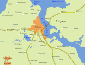
The Borgwallsee is a lake southwest of the city of Stralsund in the district of Vorpommern-Rügen in Mecklenburg-Vorpommern .
location
It is located in the municipality of Lüssow (near Stralsund) , the southern bank forms the border with the municipality of Steinhagen (Western Pomerania) , the western bank with the municipality of Pantelitz . The lake has an approximate length of 3.6 kilometers, a width of 1.8 kilometers and an average depth of 2.4 meters. In the south-west there are up to two meters thick bogs and forests, the remaining banks are used for agriculture.
The lake was formed during the Vistula Ice Age and is probably the product of shallow excavations by a glacier. Originally there was a connection up to 17 meters deep with Lake Pütter , which was filled with digested sludge and peat . This is proven by pile-driving soundings . To the west, the lake water flows through a weir regulated over the Barthe . The Mühlgraben flows through the lake from the Krummenhagener See in the south to the north in the direction of Pütter See.
Borgwall (Burgwall)
The name of the Borgwallsee suggests a fortification formerly located on its banks. On the northwestern peninsula of the lake (decimal degree coordinates 54.273986 / 12.99523), a few meters east of the outflow of the Barthe, there is evidence of a refuge from the Slav period, which is no longer recognizable today, except for an elevation. At the beginning of the 19th century this rampart no longer exists and is therefore not mentioned in von Hagenow's map of New Western Pomerania and Rügen from 1839. At that time, on the aforementioned map by Hagenows, a settlement with the name Borgwall (1888 Fischerhaus Borgwall) is recorded at the former location of the castle ramparts, of which the remains of at least two foundations of at least two buildings that were once existed are still visible today. The castle wall at Borgwallsee is seen together with the formerly existing castle wall on the Schloßberg southwest of Pantelitz (decimal degree coordinates 54.293121 / 12.961217) and the castle wall near Altenhagen (decimal degree coordinates 54.256431 / 12.777306) in a network of defensive structures from the Slav period.
Historical use
From 1242 onwards, the Neuenkamp monastery began fishing . From 1256, the mill ditch was created to supply the nearby town of Stralsund with drinking water and to drive water mills.
The lake is part of the nature reserve Borgwallsee and Pütter See and serves the city of Stralsund as a drinking water reservoir . The Lüssow waterworks, which has existed since 1894, is located on the northeast bank. Driving on the lake and swimming is not permitted due to its use.
See also
literature
- Environment Ministry Mecklenburg-Western Pomerania (Hrsg.): Borgwallsee and Pütter See 311 in: The nature reserves in Mecklenburg-Western Pomerania. Demmler-Verlag, Schwerin 2003, ISBN 3-910150-52-7 , pp. 198f.
Web links
Individual evidence
- ↑ a b c d e f g Documentation of the condition and development of the most important lakes in Germany: Part 2 Mecklenburg-Western Pomerania (PDF; 3.5 MB)
- ↑ Map of New Western Pomerania and the island of Rügen 1839, accessed on February 11, 2017 (French)
- ↑ GAIA MV Historische Karten, Mestischblätter 1888, accessed on February 12, 2017 (German)
- ↑ GAIA MV Historische Karten, Mestischblätter 1888, accessed on February 12, 2017 (German)
- ↑ Ludwig Giesebrecht , The Pomeranian Landwehr on the Baltic Sea , in Baltic Studies AF 11 2nd issue, Stettin 1845, pp. 25-26.


