
Scheden
| coat of arms | Germany map | |
|---|---|---|

|
Coordinates: 51 ° 27 ' N , 9 ° 44' E |
|
| Basic data | ||
| State : | Lower Saxony | |
| County : | Goettingen | |
| Joint municipality : | Dransfeld | |
| Height : | 222 m above sea level NHN | |
| Area : | 26.69 km 2 | |
| Residents: | 1887 (Dec. 31, 2019) | |
| Population density : | 71 inhabitants per km 2 | |
| Postal code : | 37127 | |
| Area code : | 05546 | |
| License plate : | GÖ , DUD, HMÜ, OHA | |
| Community key : | 03 1 59 031 | |
| LOCODE : | DE CEE | |
| Community structure: | 3 districts | |
| Address of the municipal administration: |
Schulstr. 2-4 37127 Scheden |
|
| Website : | ||
| Mayoress : | Ingrid Rüngeling | |
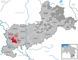
| Location of the municipality of Scheden in the district of Göttingen | ||
  |
||


Scheden is a municipality in the district of Göttingen in Lower Saxony ( Germany ).
The municipality belongs to the Dransfeld joint municipality , which has its administrative seat in the city of Dransfeld . The place Scheden arose from the places Nieder- and Oberscheden.
geography
Geographical location
Scheden is located in the Münden Nature Park at the southwest foot of the Hohe Hagens and is traversed by the eastern Weser tributary Schede . Meensen and the headwaters of the western Leine tributary Dramme are located in the southeast part of the municipality . The Brackenberg rises near Meensen , on which the remains of the Brackenburg castle ruins are located.
Community structure
The municipality of Scheden consists of the districts Scheden, Dankelshausen and Meensen .
history
The place was first mentioned in a deed of gift from King Henry III. to the Hilwartshausen monastery from 1046 mentioned in a document as a villa, quae dicitur Schitvn . The oldest part of the settlement was in the area of Oberscheden and was a drubbel with around nine farms, which was probably not significantly expanded until the 14th century after several surrounding villages had fallen into desolation . Since the beginning of the 13th century, the name form has been Sceden , Scheden or Scheiden . A distinction between Oberscheden and Niederscheden has survived since the 14th century: 1317 Nederen Scheden , 1322 Superiori Scheden mentioned in writing in 1397 in the Low German form Oueren Scheden .
On the map of the Kurhannoverschen Landaufnahme from 1785 79 fireplaces are recorded for Niederscheden and 85 fireplaces for Oberscheden. The structure of a purely agrarian town only changed in 1852 with the construction of the railway line from Göttingen to Hann. Münden, part of the Hanover Southern Railway , which made it possible for industrial companies to settle.
Incorporations
On January 1, 1973, the communities of Dankelshausen and Meensen were incorporated.
politics
Municipal council
The municipal council consists of 13 councilors.
(As of: local election on September 11, 2011 )
After the local elections in 2016, the distribution of seats remained unchanged.
mayor
The honorary mayor Ingrid Rüngeling was elected on April 29, 1996.
badges and flags

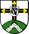
Coat of arms of the municipality of Scheden

Coat of arms of the district of Scheden
Coat of arms of the district of Dankelshausen

Coat of arms of the Meensen district

Flag of the municipality


Blazon : “Square with a blue heart shield, inside a gold (yellow) house brand in the form of an openwork triangle with a cross on top; 1 in gold (yellow) a continuous black cross, covered with three golden (yellow) clover stems; 2 and 3, a silver (white) oblique left-hand shaft bar in blue; 4 in gold (yellow) a four-ended black antler pole, the rungs of which end in six-pointed stars. "
The coat of arms was approved by the regional president in Hildesheim in 1973 . It shows elements from the coats of arms of the districts. The cross is borrowed from the local coat of arms of Dankelshausen. It records the ecclesiastical significance of the place as a parish center , the clover stalks symbolize the neighboring communities belonging to the parish. The antlers, an old Cheruscan sign with star tips, is a rare symbol in heraldry . It comes from the seal of Dietrich von Meensen from 1352. The silver wave bar symbolizes the Schede , a stream that flows through the district of Scheden; the blue areas stand for the former districts of Ober- and Niederscheden which merged in 1964 under the name Scheden. The heart shield is based on the old town coat of arms of Scheden. The golden house brand was once in the seal of Henning von Scheden, Schultheiss zu Münden .
Culture and sights
The list of architectural monuments in Scheden includes the architectural monuments of Scheden.
St. Mark's Church

The Markuskirche in Oberscheden is also known as the "Schedener Dom". It is one of the largest village churches in southern Lower Saxony. About 450 visitors can be found in the hall church, built in the late Baroque style between 1742 and 1747 , which was built in a transverse orientation on the foundations of a previous building from the 16th century. The font , which is still preserved today, also dates from this time (1577) . In 1860–1861 the interior was redesigned in such a way that it now faces east. The church interior , which has since been designed in neo-Romanesque style, has a false apse with the altar . In addition to the crucifix and figures of the evangelists, it is decorated with two half-relief pictures . They show the adoration of Jesus by the Magi and his baptism by John . The pulpit towering on the left side of the room is adorned with figures of the authors of the New Testament epistles . The church was fundamentally renovated in 1984–1989 and received two new bronze bells to replace the steel bells that were introduced in 1949 instead of the bronze bells that were removed during World War II and that were placed in front of the church as a memorial.
The original parts of the organ from 1829 are the work of Johann Dietrich Kuhlmann from Gottsbüren . Originally it had 15 registers on a manual and pedal , but was changed by Carl Giesecke in 1860 , and a Rückpositiv was added in 1937 by Paul Ott . In 2011 the organ was restored and expanded with the help of donations from the organ building company Krawinkel from Trendelburg . Since then it has had 22 stops on two manuals and pedal.
Disposition of the new organ:
|
|
|
||||||||||||||||||||||||||||||||||||||||||||||||||
- Coupling : II / I, I / P
Since 2004 there has been a permanent exhibition in the St. Markuskirche in memory of the flute master and court composer Johann Joachim Quantz, who was born in Oberscheden in 1697 . It is open from April to October on Sundays from 3 p.m. to 5 p.m. At these times, the church is also accessible outside of the services.
Desolation

About 1.5 km east of the village is the Wetenborn desert ( 51 ° 27 ′ 51 ″ N , 9 ° 45 ′ 31 ″ E ). From the village, which was abandoned at the turn of the 14th to the 15th century, remains of masonry of a pre-Romanesque church can still be seen. The east-facing building was only 10.80 × 7.00 meters in size and had a constricted rectangular choir. In the 1970s the ruin was discovered and the remains uncovered.
Museums
- Quantz exhibition in St. Mark's Church.
- Mariannes Heimatmuseum, private museum showing objects from 100 years ago
Sports
The Weser-Harz-Heide long-distance cycle path and the student path through hiking trail touch the town.
Economy and Infrastructure

There is a medical practice for general medicine , company medicine, paediatrics and emergency medicine .
traffic
Scheden is located directly on Bundesstrasse 3 , which runs from Hann. Münden leads to Göttingen . The next connection to the A 7 is Hann. Münden / Hedemünden approx. 10 km away.
From 1876 to 1980 Scheden with the Oberscheden station was connected to the Hannöversche Südbahn , which opened in 1856 , once a double-track main line, after which passenger traffic on the Dransfeld section was discontinued. The line that had already been dismantled as far as Dransfeld was used as a freight siding for a local feed manufacturer (company - Hemo) until 1995 .
Personalities

- Johann Joachim Quantz was born in Scheden in 1697 and was a musician, composer and flute teacher of Frederick the Great.
- The Göttingen Senator Justus Christoph Grünewald was born in 1764 in Niederscheden. On June 22, 1801, on his initiative, the “ Spar- und Leih-Casse ” was founded in Göttingen as the first municipal savings bank in Germany.
- From 1925 to 1926 Otto Feick built the world's first gymnastics wheel in the Niederscheden drawing and stamping plant .
- Theodor Krohne was born in Dankelshausen in 1846. He became head of the city council and honorary citizen of Königsberg i. Pr.
literature
Joachim von Stockhausen, Dankelshausen - Wellersen between Göttingen and Hann. Münden. A foray into the history of the village and the family. Disserta publishing house. Hamburg 2014. ISBN 978-3954257966
Web links
- Website of the municipality of Scheden
Individual evidence
- ↑ State Office for Statistics Lower Saxony, LSN-Online regional database, Table 12411: Update of the population, as of December 31, 2019 ( help ).
- ↑ a b Main statutes of the municipality of Scheden (PDF) . Retrieved March 3, 2019.
- ↑ Monumenta Germaniae Historica , H. Bresslau and P. Kehr (eds.): The documents of Heinrich II. In: The documents of the German kings and emperors , Volume 5, Berlin 1930. Document No. 163, p. 205
- ↑ a b c Peter Ferdinand Lufen: District of Göttingen, part 1. Altkreis Münden with the communities of Adelebsen, Bovenden and Rosdorf . In: Christiane Segers-Glocke (Hrsg.): Monument topography Federal Republic of Germany. Architectural monuments in Lower Saxony . tape 5.2 . CW Niemeyer, Hameln 1993, ISBN 3-87585-251-6 , p. 245 ff .
- ↑ Kirstin Casemir, Uwe Ohainski, Jürgen Udolph: The place names of the district of Göttingen . In: Jürgen Udolph (Hrsg.): Lower Saxony Place Name Book (NOB) . Part IV. Publishing house for regional history, Bielefeld 2003, ISBN 3-89534-494-X , p. 356 ff .
- ^ Federal Statistical Office (ed.): Historical municipality directory for the Federal Republic of Germany. Name, border and key number changes in municipalities, counties and administrative districts from May 27, 1970 to December 31, 1982 . W. Kohlhammer GmbH, Stuttgart and Mainz 1983, ISBN 3-17-003263-1 , p. 213 .
- ↑ http://wahlen.kds.de/2011kw/Daten/152401_000028/index.html
- ↑ http://scheden.de/?page_id=53
- ↑ Münden church district
Adelebsen | Bad Grund (Harz) | Bad Lauterberg in the Harz Mountains | Bad Sachsa | Bilshausen | Lake Constance | Bovenden | Charging | Dransfeld | Duderstadt | Boar idols | Elbingerode | Friedland | Gieboldehausen | Same | Göttingen | Hann. Münden | Hattorf am Harz | Herzberg am Harz | Hörden am Harz | Jühnde | Krebeck | Landolfshausen | Niemetal | Obernfeld | Osterode am Harz | Jump | Rollshausen | Rosdorf | Rüdershausen | Scheden | Seeburg | Seulingen | Staufenberg | Waake | Walkenried | Wollbrandshausen | Wollershausen | Wulften am Harz
Community-free area in the district of Göttingen
Harz (district of Göttingen)