Dransfeld
| coat of arms | Germany map | |
|---|---|---|

|
Coordinates: 51 ° 30 ' N , 9 ° 46' E |
|
| Basic data | ||
| State : | Lower Saxony | |
| County : | Goettingen | |
| Joint municipality : | Dransfeld | |
| Height : | 301 m above sea level NHN | |
| Area : | 28.75 km 2 | |
| Residents: | 4438 (Dec. 31, 2019) | |
| Population density : | 154 inhabitants per km 2 | |
| Postal code : | 37127 | |
| Area code : | 05502 | |
| License plate : | GÖ , DUD, HMÜ, OHA | |
| Community key : | 03 1 59 009 | |
| LOCODE : | DE DXD | |
| City structure: | 4 districts | |
City administration address : |
Kirchplatz 1 37127 Dransfeld |
|
| Website : | ||
| Mayor : | Carsten Rehbein ( SPD ) | |
| Location of the city of Dransfeld in the district of Göttingen | ||
Dransfeld is a town in southern Lower Saxony in the district of Göttingen and the seat of the Dransfeld community .
geography
location
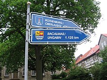
Dransfeld is about halfway between the university town of Göttingen and the half-timbered town of Hann. Münden . The city lies at the foot of the western Bramwald and the southern Dransfelder Stadtwald , is traversed by the Auschnippe and crossed by a section of the Frau-Holle-Route of the German Fairy Tale Route . South of Dransfeld is the mountain Hoher Hagen , which is one of the highest mountains in the southern tip of the state of Lower Saxony.
City structure
history
Dransfeld is mentioned for the first time in a list of goods from Hilwartshausen Monastery as Threnesfelde , which was signed by King Otto I in 960. Dransfeld was already a town-like settlement at the beginning of the 14th century. The first evidence of a council in Dransfeld can be found for the year 1345, but the full town charter based on the model of the Münden town charter was not granted to the town council until 1368 by Duke Otto the Quaden . In older literature, however, there is an indication that Dransfeld received town charter as early as 1305. It is also mentioned that the place emerged from various monasteries belonging to the St. Michaelis monasteries in Hildesheim , Mariengarten , Hilwartshausen and Bursfelde . The city was badly damaged in the Star Wars , and from 1430 the construction of strong fortifications is documented. During this time, Dransfeld was mentioned for the second time as a city. In a feudal letter in which Landgrave Ludwig von Hessen , on the orders of Emperor Sigismund , enfeoffed Duke Otto II of Braunschweig with the principality of Braunschweig, Dransfeld is mentioned as a castle town in 1420. According to this, the old prince's castle must have stood at that time, which was significantly damaged in the Star Wars. In an old message that reports on the destruction of Dransfeld in 1374, the location of the castle can also be found, which is Anno Domini MCCCLXXIV. is Dransfeld razed by the Hessians and Döhringers, Wall and Wothergroben ingereten and uth the Grounan afgebrandt. Duke Otto lived here for Thieth. Dat castle has put Howe in the miners' barges . In that 15th century there was also a noticeable decline in the economic development of Dransfeld, for example the settlement "Im alten Dorfe" southwest of the city was abandoned and the Kaland was relocated from St. Johannis to Göttingen. A little later, the Dransfelder received the mountain Hohen Hagen from the Hilwartshausen monastery, including all accessories, lands and the right to log. For this they commit themselves in a lapel of 1529 to be loyal and devoted to the monastery in all things and to provide help with the collection of interest from the monastery to the Dransfelders. The reverse also shows that Albrecht Bomgarten was mayor of Dransfeld at the time.
In the Thirty Years' War , Tilly's troops conquered the city in 1634, and 104 town houses and 60 barns were destroyed. The patrician dynasty of those at Dransfeld in Göttingen has been proven by the end of the 18th century at the latest . They got their name from their predecessors, the nobles of Dramfeld, who originally lived on the river Dramme and had a free, aristocratic estate and castle courtyard in Dramfeld. After this burned down, the gentlemen von Dransfeld settled in Göttingen and Obernjesa . Meinhard was probably not a representative of the von Dransfeld family, who, like other representatives of the house, often rose to high dignity as a founder. Meinhard held the office of bishop in Halberstadt in the 13th century and in 1245 transferred the fruit tithes from the neighboring fields to the Riddagshausen monastery .
On January 26, 1834, most of the city of Dransfeld burned down again. Subsequently, the city plan was changed significantly, the streets were widened and the building lines straightened, new streets were laid out according to plan taking into account the old street structure. The city gradually recovered from the fire in the following years, so the population of Dransfeld rose continuously until 1870. the cessation of lignite mining and other enterprises let the place take on the form of a quiet agricultural town, the largest industrial enterprise in the area of the place represented only the basalt quarry "Hoher Hagen".
From 1856 to 1980 Dransfeld was on the Hannöversche Südbahn , once a double-track main line from Göttingen to Hann. Münden , connected to the national railway network. In order to avoid a route over the Hessian region, the route from Göttingen was led with enormous inclines over Dransfeld and was given the nickname Dransfelder Rampe . Until the electrification of the connection via Eichenberg in 1963, it was an important long-distance route, after which only a few local trains remained until passenger traffic ceased in May 1980 and the section to Göttingen was dismantled. Until the end of the 1980s, the section to Hann. Münden is still used as a freight siding.
Origin of the place name
Old names of the place are 960 Trhenesfelde, 1022 Dransuelt, 1022 Dransvelt, 1078 Thransfellensem, 1089-93 Triensuelt, 1089-93 Triensvelt, 1093 Dransfelde and 1125 Transfeldun. "Thran" means "modern", "lazy". The place name Dransfeld ("Thranas field") most closely means "place with rotten, rotting swamp plants".
Incorporations
On July 15, 1968, the municipality of Bördel was incorporated. On January 1, 1973, the communities Ossenfeld and Varmissen were incorporated.
politics
City council
The city council of the city of Dransfeld consists of 15 council women and councilors.
- SPD : 6 seats
- CDU : 5 seats
- Greens : 3 seats
- Free voter community Dransfeld : 1 seat
(As of: local election on September 11, 2011 )
Local election September 11, 2016:
- SPD: 5 seats
- CDU: 4 seats
- FWGD: 4 seats
- B90 / The Greens: 1 seat
- The LEFT: 1 seat
badges and flags
Blazon : "In red a striding black armored golden (yellow) lion."
The coat of arms goes back to a city seal after 1305. It shows the lion of the Duchy of Braunschweig, Göttingen line . The lion appeared at first turned to the left and looking forward. Klemens Stadler showed him in the black shield.
The flag can be described as black and yellow with horizontal stripes with an applied coat of arms in the middle.
Partner communities
(Source:)
Culture and sights
Buildings
church
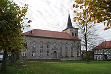
The Evangelical Lutheran town church of St. Martini was rebuilt in neoclassical style after the devastating fire in 1834 and inaugurated in 1841. For the reconstruction, only parts of the tower could be taken over from the Gothic previous church. The architect was the Hanover consistory master builder Ludwig Hellner . The large interior is characterized by the wide-span flat ceiling and the segment-arched apse with six high columns. The church has a circumferential gallery, which is taken up on the west side by a wide organ. The organ was built from 1843 to 1845 by Balthasar Conrad Euler from Gottsbüren near Trendelburg, restored in 1985 and has been a listed building since then. The church was restored from 1981 to 1984.
additional
The new Gauss Tower , which was built on the Hohe Hagen in 1964 , is the landmark of the city of Dransfeld that can be seen from afar with a total height of 51 meters. The St. Martini Church is one of the historical buildings.
There is a Jewish cemetery with 131 tombstones on the northeast slope of the Dransberg . It is considered a cultural monument worthy of protection . The former synagogue is also still preserved.
See also the list of architectural monuments in Dransfeld .
Natural monuments
One of the most famous cultural monuments in the Göttingen area are the altar stones on the Hengelsberg in Dransfeld's city forest. It is a conspicuous group of quartzite blocks that were not mined for industrial purposes. The block to the north is 3.4 m long, 2 m wide and protrudes about 70 cm from the ground. The surface is relatively uneven, but 10 to 15 depressions were also found, which, with their regular circular shape and clear delimitation, make it clear as man-made. With these markings on the stone, it belongs to the group of so-called " bowls " - or "cup stones", a type of primeval monuments that have a controversial meaning. A similar shell stone in the Göttingen area is that of Wiershausen, which was found 5.5 km as the crow flies, from those in the Dransfeld forest. The oldest of the altar stones on the Hengelsberg have been wearing the peculiar bowls since the Neolithic Age , but most of them only got their designs in the Bronze Age. Another quartzite block shows long grooves on its surface , as they are known from medieval churches, since the ground stone flour was used as a remedy at that time. Shards from the 14th century were found under a third stone, which confirms the assumption that those grooves date from the end of the Middle Ages .
Other natural monuments in the Dransfeld Forest on the southern slope of the Hengelsberg include the "Hohle Stein", a chair-shaped block of quartzite which is dated to the Stone Age , and two groups of burial mounds from an unknown time, which could possibly be end-Neolithic and the late medieval pottery desert "Gropenhagen", with waste dumps, kiln and building remains.
Sports
Every year on May 1st, the Hasenmelker run takes place in Dransfeld, a 10 km long Volksberg run that leads from Dransfeld over the Hohen Hagen. The largest sports club in town is the Dransfelder Sport-Club e. V.
The Tour d'Energie, the annual bike tour from Göttingen, also leads through Dransfeld and over the Hohen Hagen.
Economy and Infrastructure
Mining
Between 1825 and 1987 there was an important mining site for basalt at the Hohen Hagen near Dransfeld, which was used as track ballast, additive for concrete mixtures and as building material. Large parts of the cobblestones in Göttingen also consist of Dransfeld basalt. The new Gauss tower stands on the edge of a basalt quarry.
traffic
The federal highway 3 connects Dransfeld with Hann. Münden or Göttingen. To the east of the city, 9 km from Göttingen, the federal motorway 7 runs via Hanover - Kassel . The Drammetal triangle offers a connection to the federal motorway 38 to Halle (Saale) and Leipzig .
The local public transport (ÖPNV) connects Dransfeld via the bus line 120 of the RBB with Hann. Münden or Göttingen.
The Göttingen train station is located on the Hanover-Würzburg high-speed railway and is a long-distance support. The ICE connections run via Göttingen from Hamburg – Hanover to Munich / Basel and from Berlin – Braunschweig to Frankfurt – Stuttgart / Basel. Until May 1980 there was a train station in Dransfeld on the Hannöverschen Südbahn between Göttingen and Kassel, but this section of the route has been dismantled and the trains run via Eichenberg . The nearest airports are in Hanover , Kassel and Paderborn .
The Weser-Harz-Heide-Radfernweg , which leads in both directions over sections of the former Dransfeld ramp (see history ) , also leads through Dransfeld .
tourism
The Hoher Hagen forest swimming pool in Dransfeld offers, among other things, a sports pool and a children's adventure / attraction pool with a large water slide, white water canal, underwater boilers, mushrooms and water cannons.
Dransfeld has a country hotel and a campsite, which is located right next to the forest swimming pool. Bördel has the only nudist campsite in the Göttingen district.
There is a network of hiking and forest trails around the Hohe Hagen, including the Loccum – Volkenroda pilgrimage route .
Personalities
Honorary citizen
- Excellency and Privy Councilor Hermann August Gieseke (1846–1926), Head of the Post Office in Constantinople (1881–1885), Department Director at the Reich Post Office (1901–1908), Honorary Chairman of the Gauss Tower Building Committee
Daughters and sons of the city
Sorted by year of birth
- Johann Jeep (1582–1644), composer
- Theodor Hoebel (1832–1908), hydraulic engineer, builder of the Bremerhaven fishing port
- Paul Isenberg (1837–1903), sugar manufacturer
- Johann Friedrich Crome (1906–1962), classical archaeologist
- Rolf Zick (* 1921), journalist
- Christa Ludewig (* 1953), member of the state parliament (CDU)
- Pauline Bremer (* 1996), soccer player
literature
- Wilhelm Lotze: History of the city of Dransfeld along with the humorous history of the Hasenmelkers and Asinusfräters . Klugist Verlag, Münden 1878.
- Karl Ludewig: History of the city of Dransfeld. Karl Ludewig writes from the years 1305–1967 . Ed .: Gottfried Nolte. Dransfeld 1967.
- Friedel Rehkop, Karl-Alfred White: City of Dransfeld. A historical look back from the 19th century to the early days . Geiger Verlag, Horb am Neckar 1999, ISBN 3-89570-561-6 .
Web links
- City of Dransfeld
- Illustration by Daniel Meisner from 1624: Dransfeld; Anne Fores Veræ Pandit Amicitiæ.s ( digitized version )
Individual evidence
- ↑ State Office for Statistics Lower Saxony, LSN-Online regional database, Table 12411: Update of the population, as of December 31, 2019 ( help ).
- ^ The documents Konrad I, Heinrich I and Otto I. In: Monumenta Germaniae Historica , The documents of the German kings and emperors, Volume 1. Hanover 1879-1894. No. 206, p. 284 ff.
- ^ Peter Ferdinand Lufen: District of Göttingen, part 1. Altkreis Münden with the communities of Adelebsen, Bovenden and Rosdorf . In: Christiane Segers-Glocke (Hrsg.): Monument topography Federal Republic of Germany. Architectural monuments in Lower Saxony . tape 5.2 . CW Niemeyer, Hameln 1993, ISBN 3-87585-251-6 , p. 109 .
- ^ Hermann Guthe : The Lands of Braunschweig and Hanover . Shown geographically with consideration for the neighboring areas. Klindworth's Verlag, Hannover 1867, p. 393 .
- ↑ Georg Heinrich Klippel: Göttingen and its surroundings. A paperback especially for students and travelers . Ed .: Heinrich Veldeck. tape 2 . Rosenbusch Verlag, Göttingen 1824, p. 206 .
- ^ Contributions to the history of the city of Dransfeld . In: New Hanover magazine . tape 19 . Schlueter Verlag, Hannover 1810, p. 814 .
- ^ A b Peter Ferdinand Lufen: District of Göttingen, part 1. Altkreis Münden with the communities of Adelebsen, Bovenden and Rosdorf . In: Christiane Segers-Glocke (Hrsg.): Monument topography Federal Republic of Germany. Architectural monuments in Lower Saxony . tape 5.2 . CW Niemeyer Verlag, Hameln 1993, ISBN 3-87585-251-6 , p. 109 ff .
- ↑ Joachim Meier: Origines Et Antiqvitates Plessenses. That is: Pleiß origin and memorabilia . König Verlag, Goslar 1713, p. 20th ff .
- ^ Bernhard Hausmann: Memories from eighty years of life. Hanover 1873, p. 140.
- ^ Jürgen Udolph (research): The "place name researcher". (No longer available online.) In: Internet site NDR 1 Lower Saxony . Archived from the original on January 26, 2016 ; accessed on August 3, 2019 .
- ↑ Law on the incorporation of the municipality of Bördel into the city of Dransfeld of July 15, 1968.
- ^ Federal Statistical Office (ed.): Historical municipality directory for the Federal Republic of Germany. Name, border and key number changes in municipalities, counties and administrative districts from May 27, 1970 to December 31, 1982 . W. Kohlhammer, Stuttgart / Mainz 1983, ISBN 3-17-003263-1 , p. 213 .
- ↑ wahlen.kds.de
- ↑ ratsinformationsdienst.dransfeld.de
- ↑ Flag and coat of arms of Dransfeld
- ^ City of Dransfeld: partner communities. ( Memento from April 24, 2011 in the Internet Archive ) In: Website City of Dransfeld. Retrieved August 23, 2019.
- ^ Olaf Höckmann: Guide to prehistoric and early historical monuments. Göttingen and the Göttingen Basin . Ed .: Römisch-Germanisches Zentralmuseum. tape 16 . von Zabern Verlag, Mainz 1970, ISBN 3-8053-0131-6 , p. 138 .
- ↑ Routes of the Tour d'Energie on the website of the organizer, accessed on April 1, 2016.
- ↑ From the life of a successful postman / memories of Ministerialdirektor a. D. exc. August Gieseke. In: Postal history sheets from the Weser-Ems area. 1,9, 1958, pp. 145 ff.
- ↑ Jan-Otmar Hesse: In the network of communication: The Reichs-Post and Telegraphenverwaltung. 1876-1914, 2002, p. 111.
- ↑ Reinhard Bojer: Emsländische Heimatkunde in National Socialism. Volume 3, 2005, p. 271.
- ↑ August Gieseke, Felix Klein , Karl Schwarzschild : About the construction of a Gauss tower near Göttingen. In: Astronomical News. No. 179, 1908.


