
Bad Sachsa
| coat of arms | Germany map | |
|---|---|---|

|
Coordinates: 51 ° 36 ' N , 10 ° 33' E |
|
| Basic data | ||
| State : | Lower Saxony | |
| County : | Goettingen | |
| Height : | 357 m above sea level NHN | |
| Area : | 33.13 km 2 | |
| Residents: | 7372 (Dec. 31, 2019) | |
| Population density : | 223 inhabitants per km 2 | |
| Postal code : | 37441 | |
| Primaries : | 05523, 05525 | |
| License plate : | GÖ , DUD, HMÜ, OHA | |
| Community key : | 03 1 59 004 | |
| LOCODE : | DE BSC | |
City administration address : |
Bismarckstrasse 1 37441 Bad Sachsa |
|
| Website : | ||
| Mayor : | Office z. Not busy at the moment ( see text entry ) | |
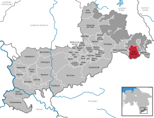
| Location of the city of Bad Sachsa in the district of Göttingen | ||
  |
||


Bad Sachsa (until 1905 Sachsa ) is a small town in Lower Saxony on the southern edge of the Harz Mountains in the district of Göttingen , about 50 km east of Göttingen . The place is a state-approved climatic health resort .
geography
location
The Uffe flows through the place; The artificially created melting pond is located near the town center . The highest point in the vicinity is the Ravensberg at 659 m above sea level. NHN about 5.5 km northwest of the city center.
City structure
The city of Bad Sachsa consists of the following four districts:
| District | Residents |
|---|---|
| Bad Sachsa (with the district Nüxei ) | 6215 |
| Steina | 730 |
| Neuhof | 687 |
| Tettenborn (with the district Tettenborn-Kolonie) | 599 |
| City of Bad Sachsa | 8231 |
(As of September 1, 2017)
Neighboring communities
Neighboring communities in Lower Saxony are Bad Lauterberg in the Harz Mountains , Walkenried and Hohenstein in Thuringia .
history


Middle Ages to modern times
The first written mention of the place was in 1219; The reference to a document that was issued by the monastery in Walkenried as a purchase contract for a lake near the settlement of Saxa - now Bad Sachsa - from around 810, in which the place is said to have been mentioned for the first time, is incorrect . Since there is talk of a pastor Siegfried from Sachsa in 1229, it can be assumed that Sachsa already existed at that time. The oldest preserved building is the tower of the (today Protestant) St. Nikolai Church ; its construction is dated between 1180 and 1200. On the Sachsenstein , on the Bad Sachsa - Walkenried near Neuhof railway line, there is the ruin of the Sachsenburg, which the German King Heinrich IV had built around 1070, but which, due to local resistance, was already unfinished in 1074 Part of the peace of Gerstungen had to be canceled again.
Since 1238 at the latest, Sachsa belonged to the County of Honstein , before that it belonged to the County of Klettenberg . Between 1516 and 1525 (probably 1525) Sachsa acquired city rights. After the Counts of Honstein died out in 1593 (Ernst VII left no male heir), the Counts of Schwarzburg and the Counts of Stolberg claimed the county. But the administrator of the Diocese of Halberstadt took possession of the county, which he withdrew as a settled fiefdom and lent it on to the Duke of Braunschweig-Wolfenbüttel (the special thing about this is that the Administrator of the Diocese of Halberstadt and the Duke of Braunschweig-Wolfenbüttel are one and the same person were; it was Heinrich Julius von Braunschweig-Wolfenbüttel ). Although the action brought by the Counts of Schwarzburg and von Stolberg before the Reich Chamber of Commerce led to a favorable verdict, Heinrich Julius and his successors refused to sell the county. In the course of the Thirty Years War , the rulership changed several times until the county was occupied by the Swedish in 1648.
In the Peace of Westphalia , the Principality of Halberstadt and the County of Hohenstein were given to the Elector of Brandenburg. Since then, Sachsa was Brandenburg-Prussian, with the exception of the French period from 1807 to 1813. After Prussia gained considerable territories in the Congress of Vienna , the kingdom was divided into ten provinces in 1816. One of them was the newly created province of Saxony. Sachsa was in this province in the administrative district of Erfurt and in the district of Nordhausen, which was named Grafschaft Hohenstein from 1888. This affiliation remained until July 1945.
Tourism in Bad Sachsa began around 1860, and the spa business began in 1874. In 1900 there were 4051 spa guests and 2123 inhabitants. The city has been officially called Bad Sachsa since 1905 . In the mid-1920s, 3195 inhabitants were counted.
National Socialism
During the time of National Socialism , the site developed into a focus of the NSDAP in the Nordhausen-Südharz party district (the Fritz-Sauckel-Haus district training center was built here) and was heavily guarded. For this reason the children from the families of the assassins were taken into kin custody in Bad Sachsa on July 20, 1944 and interned in a children's home of the National Socialist People's Welfare (NSV).
In the autumn of 1944 the archive and the picture center of the Peenemünde Army Research Center (HVA) were relocated to Bad Sachsa under the cover name "Ostverlag". Because of the British bombing raids on Peenemünde at the end of the Second World War , the Dornberger staff with 450 rocket technicians from the HVA, including Walter Dornberger , Wernher von Braun and Helmut Gröttrup , was housed on Pfaffenberg in Bad Sachsa and in places in the vicinity from February 17, 1945 . Because of the heavy bombing raids on Nordhausen on April 3 and 4, 1945 and the rapid advance of the Allied troops, this workforce was transported to Oberammergau on April 6, 1945 under the guard of the SS .
The production of the V1 and V2 rockets was organized from January 1944 by Mittelwerk GmbH under the direction of the Ministry of Armaments and the SS by prisoners from the nearby Mittelbau-Dora concentration camp in an underground tunnel in Kohnstein near Nordhausen .
Occupation zones 1945
On April 12, 1945, Bad Sachsa was occupied by American troops after short fighting. From the beginning of July the Americans withdrew to the zone of occupation assigned to them by the London Protocol of September 12, 1944 . The following them Soviet troops left Bad Sachsa that in the Soviet zone of occupation was, but unoccupied, to British troops on July 23, the city occupied . This was preceded by an exchange of territory between the British and the Soviet high command, in which Bad Sachsa and the surrounding area (the neighboring town of Tettenborn was also affected) fell under the British occupation zone and the eastern part of the Brunswick district of Blankenburg came under the Soviet occupation zone. The district of Osterode am Harz, to which Sachsa had de facto belonged since mid-July 1945, was also de jure incorporated on September 1, 1945.
After 1945
From 1960 to 1961 the youth hostel was built on site according to plans by the architect Hans Jaeckel . The Kursaal Bad Sachsa was also built between 1962 and 1963 based on Jaeckel's designs.
Since the merger of the districts of Osterode am Harz and Göttingen on November 1, 2016, Bad Sachsa has belonged to the district of Göttingen .
Incorporations
On July 1, 1972, the neighboring towns and communities Neuhof (formerly Braunschweigisch ), Steina (formerly Hanoverian ) and Tettenborn were incorporated.
Place name
Former place names of Sachsa were in the years 1219 Saxa, 1232 Sassa, 1237 Saxa and 1238 Sassa. The meaning of the place name Sachsa is not clear. It is most likely to be justified with “Sahs-aha” for being allowed to see . The basic word is probably the Germanic "aha" for "water, river, brook". In addition, the developed "Sahs-" for "stone" is probably included. The name would then have meant "Steinbach". Possibly it referred to the Uffe river or the Sachsengraben as a section name that was retained in the place name.
Religions
Christianity

Bad Sachsa are the Evangelical Lutheran parish of St. Nicholas and municipalities in the districts of Neuhof, Steina and Tettenborn. The parish of Bad Sachsa used to belong to the Evangelical Church of the Church Province of Saxony and was looked after by the Evangelical Church of Westphalia during the division of Germany . It was only through a contract between the two church leaderships in October 1996 that the congregation was incorporated into the Herzberg parish of the Evangelical Lutheran Church in Hanover ; With the amalgamation of the Herzberg, Osterode and Clausthal-Zellerfeld church districts to form the Harzer Land church district on January 1, 2013, the St. Nikolai parish now belongs to this church district. The community has the church of the same name on Kirchstrasse and the neighboring Luther House.
The Roman Catholic St. Josef Church is located on Herderstrasse, it belongs to the parish of St. Benno in Bad Lauterberg . As early as 1931, a small Catholic church St. Josef was inaugurated on Herderstrasse. The current church was built from 1961 to 1963. The Catholic house Tannenried on Bismarckstrasse, originally built in 1910 as a factory owner's house, was closed in 2009. There was a small chapel in the house.
The New Apostolic congregation Bad Sachsa was founded in 1977, it belongs to the Göttingen church district and has a church on the Ringstrasse that was consecrated in 1979.
The Jehovah's Witnesses have a Kingdom Hall on the Steinaer road.
Denomination statistics
According to the 2011 census , 55.5% of the population were predominantly Protestant , 10.2% Roman Catholic and 34.3% were non-denominational , belonged to another religious community or did not provide any information. The number of Protestants and Catholics has fallen since then. As of May 1, 2019, 4,000 (48.8%) of the 8,168 inhabitants were Protestant, 788 (9.6%) Roman Catholic and 3480 (42.6%) were non-denominational or belonged to another religious community.
Dialect border
Bad Sachsa is located immediately south of the Benrath line and thus at the transition from the High German - more precisely: the East Central German dialects to the Low German language .
politics
|
City council election 2016
Turnout: 55.42 (2011: 56.32%)
% 40 30th 20th 10
0
36.60%
30.22%
12.28%
8.05%
7.95%
4.91%
n. k.
no
Gains and losses
|
City council
The city council of Bad Sachsa consists of 20 councilors. This is the specified number for a municipality with a population between 7001 and 8000 inhabitants. The 20 council members are elected by local elections for five years each. The current term of office begins on November 1, 2016 and ends on October 31, 2021.
The full-time mayor is also entitled to vote and sit on the city council.
The last local election on September 11, 2016 resulted in the following:
- CDU : 7 seats (−1)
- SPD : 6 seats (−1)
- FDP : 2 seats (± 0)
- GREEN : 2 seats (± 0)
- Voter group ACTIVE: 2 seats (+2)
- LKR (elected under the name ALFA): 1 seat (+1)
mayor
The full-time mayor has been Axel Hartmann (CDU) since November 1, 2014 . He won the mayor election in July 2014 against the long-time incumbent Helene Hofmann (SPD), who was the city's first full-time mayor. Hartmann resigned from his position on March 31, 2018 for health reasons and has moved back to Bratislava .
His deputy took over the official business until the new election . The deputies are City Councilor Uwe Weick, Werner Bruchmann (CDU) and Ralph Boehm (SPD).
After a vacancy of over two and a half years , there will be a mayoral election in Bad Sachsa on November 22, 2020.
coat of arms
Today's municipal coat of arms of the city of Bad Sachsa corresponds to the design of the coat of arms drawn up in 1938 by the State Archives Councilor Otto Korn in the Reich Archives in Magdeburg. But the motif is much older. As early as 1838 the city forester received a paddock with a paddock lock on which the "half oak tree with six fruits" could be seen. The oak in the coat of arms of Bad Sachsa was therefore not included as a coat of arms symbol until the “Third Reich”. The city council of Bad Sachsa decided on September 14, 1950 that the city's coat of arms in the version produced by the Magdeburg State Archives should continue to be valid. The coat of arms was approved on April 2, 1953 by the Lower Saxony Ministry of the Interior .
|
|
Blazon : " Cleaved shield , front in silver on green floor of protruding from the gap a half green oak tree with six golden acorns , rear split , the top of Silver a border, black , red - bezungter Hirsch , down red and silver checkered ." |
| Justification of the coat of arms: The front half of the coat of arms shows either a conifer or a deciduous tree over the centuries. In any case, the tree stands for the hunting rights of the city in the Harz Forest. The rear half of the coat of arms has remained unchanged since 1525. The black stag is the coat of arms of the Counts of Klettenberg , to whose county Sachsa in the 12th / 13th centuries. Century belonged. In 1238 Sachsa fell to the Counts of Hohnstein . Their tournament and battle symbols were the slaughtered shield. The Hohnsteiner gave Sachsa city rights. The family died out in 1593. |
Town twinning
-
 Castelnau-de-Médoc , French commune in the Gironde department , since 1973
Culture and sights
Buildings
town hall
The town hall of Bad Sachsa, which is located in the city park with Schmerl fountain, was built in Art Nouveau style with bay windows and a pavilion. Particularly noteworthy is the conference room, which is entirely in the Art Nouveau style.
St. Nicholas Church

The St. Nikolai Church is the oldest building in the city. The west tower of the church, built around the middle of the 12th century in the Romanesque style, to which the current nave was added around 1300, dominates the city center of Bad Sachsa. The altar was donated in 1595 by the then mayor Hansen Hartmann, and in 1680 the church received a circumferential gallery inside and in 1691 a half-timbered porch with a portal outside . The baroque interior with a pulpit from 1711 is worth seeing.
From the hill on which the church rises in the city center, there is a beautiful view of the lively Marktstrasse, the city's main shopping street.
Sachsenburg
Also a little south of Bad Sachsa on a hill in the forest is the ruin of the Sachsenburg castle . The stump of a tower ten meters in diameter is particularly impressive. Excavations took place here from 1891 to 1893.
Museums
Bad Sachsa winter sports and local history museum
In the winter sports and local history museum (Hindenburgstraße 6) the origins of the place with its eventful history are presented in words and pictures. Shoemakers and plumbers as well as a four-hundred-year-old cooper's workshop are on display . Next to it is a 19th century loom . One focus is dedicated to winter sports ; Among other things, the self-made steering sledge of the German luge master (1952, 1954) as well as many skis from the local production can be seen.
Frontier Museum

The Grenzlandmuseum - Bad Sachsa was opened on November 12, 1992, exactly three years after the provisional border opening on the B 243 between Mackenrode (Thuringia) and Nüxei (district of Bad Sachsa / Lower Saxony), in the village community center of the Tettenborn district , just a few hundred meters from removed from the former inner-German border . Until it moved to the Haus des Gastes in the Vitalpark of Bad Sachsa in December 2016 , the museum presented a large number of original pieces of equipment from the GDR border troops in its collection for almost 24 years and documented spectacular border breaches and life in the border area.
After the relocation required by the authorities and the resulting redesign, the museum was opened on December 16, 2016 by the Förderverein Grenzlandmuseum Bad Sachsa e. V. newly opened. The museum focuses on the 45 years of German division between 1945 and 1990, focusing on the events in the southern Harz region . In terms of content, exhibits and dioramas on the history of development and the organization of the border regime established by the former GDR , including the pioneering blocking devices, take up a large space in the permanent exhibition.
Other museums
The NatUrzeitmuseum Bad Sachsa offers an overview of 290 million years of natural history of the southern Harz. In the Steina district there is a glass museum that provides information about glass production and Harz forest glass .
Vital Park
Above Hindenburgstrasse is the historic spa park, laid out in 1889, with a music pavilion (a music pavilion has existed since 1902), a foyer (built in 1939), a spa house (built in 1962/63) and a tourist information center (built in 1982) Kurpark now the new name Vitalpark .
In the Vitalpark you will find the NatUrzeitmuseum , the Grenzlandmuseum , a facility for treading water , a barefoot path, some outdoor fitness equipment , a mini golf course and three tennis courts . The four-star superior Göbel's Vital Hotel , built in 1904, is located at the main entrance .
Melt pool
The 7 hectares large Schmelzteich is an artificial lake in Vital Park (formerly spa). The five-star Hotel Romantischer Winkel, opened in 1978, is located on the west bank of the Schmelzteich .
Roman stone
Worth seeing is a legendary, rugged rock formation south of the city, which is said to be named after a young man named Roman from a family of giants. Not far from the Römerstein , the remains of a settlement from around 10,000 BC were found. Discovered.
Ravensberg
The 659 m above sea level. NHN high Ravensberg is Bad Sachsa's local mountain . On top of it is a transmission tower built in 1970 and visible from afar, which is now used by Deutsche Telekom . The Ravensberg is the only mountain in the western Harz that can be climbed by car. Marked hiking trails and mountain bike tours with varying degrees of difficulty start here. Winter sports enthusiasts can use a ski area with several lifts, two toboggan runs and the connection to the southern Harz cross-country ski trail network . There is also a floodlight system. The mountain summit offers a panoramic view, from which the Kyffhäuser , the Weserbergland and various Harz mountains, including the Brocken , can be seen.
Harzfalkenhof
The Harzfalkenhof bird of prey park is located on the Katzenstein on the outskirts of Bad Sachsa . Different species of birds of prey are shown here and there are flight demonstrations.
Fairytale reason
The Märchengrund in Katzentalstrasse was built in 1910 and is one of the oldest fairytale parks in Germany.
Nature reserves
Not far from the village are the nature reserves " Gipskarstlandschaft Bad Sachsa and Walkenried " and " Priorteich / Sachsenstein ".
music
- Spa concerts in the Vitalpark or in the Kurhaus
- Church concerts in St. Nikolai and St. Josef
- Walkenried cloister concerts
- Herzberg Castle Concerts
Sports
- Salztal Paradies (adventure pool, ice rink, sauna, wellness)
- Rainbow Land (fitness, bowling, indoor playground)
- Ravensberg Basecamp (climbing hall)
- Priorteich forest swimming pool - Sachsenstein
- Hiking (guided hiking tours from the Bad Sachsa Tourist Information Office)
- Sailing on the Oder dam
- Riding stables in Neuhof (Reit und Fahrverein Pferdefreunde Neuhof), Tettenborn (ISI-LAND) and Bartolfelde (Reiterverein Südharz)
- Ravensberg ski and sports center
- Bad Sachsa ice hockey school
societies
- Schützengesellschaft von 1814 Bad Sachsa (All districts have their own shooting clubs)
- WSV - Wintersportverein Bad Sachsa from 1911 (from 2019 WSV Südharz )
- Green - White Bad Sachsa (tennis club)
- VfB Bad Sachsa from 1961 (football club)
- Franco-German Society (town twinning association, founded 1973)
- Kulturforum Bad Sachsa (cultural association)
Regular events
- Adventure market (every Wednesday 4:00 p.m. to 9:00 p.m.)
- Sachsaer pubs night
- Sachsaer Food Truck Festival
- Folk and rifle festival
- Summer of music in the Vitalpark or Kurhaus
- White Dinner on the Schmelzteichdamm
- Festival of lights in the Vitalpark
- City festival
- Wine festival
- Christmas Market
Economy and Infrastructure
tourism
From the middle of the 19th century, tourism developed into an important branch of the economy. The city has been known as Bad as a health resort since 1905.
Financial institutions
The Stadtsparkasse Bad Sachsa was until 31 December 2019, the smallest independent savings bank in Germany. In 2017, it had total assets of EUR 131.99 million, 39 employees and only one branch. The Stadtsparkasse was originally supposed to cooperate with the other savings banks in the Göttingen district, the Sparkassen Duderstadt, Hann. Münden and Osterode am Harz merge. On January 1, 2020, the previous Sparkasse Osterode am Harz and the former Stadtsparkasse Bad Sachsa merged to form Sparkasse Osterode am Harz .
Since the 1960s there has also been a branch of Volksbank im Harz in Bad Sachsa, first in Hindenburgstrasse, now in Uffestrasse opposite the town hall.
The German bank has been closing its branch in Bad Sachsa only self - and ATMs in the market street.
education


The boarding high school Pädagogium Bad Sachsa (also called "Päda"), located in the Ostertal near the spa park (today Vitalpark ), describes itself as the oldest independent school in northern Germany . The pedagogy with its old school buildings from different eras and the listed old gym shape the townscape in the Ostertal. In front of the entrance to the school grounds is the student memorial donated by former students - the Frechdachs . Rolf Kalmuczak , the author of the youth crime series TKKG , is one of the well-known personalities who attended the pedagogy during their school days . Therefore, the locations of the radio play can be found partly in Bad Sachsa and the surrounding area.
There is also a high school , a primary school , a private music school and three public kindergartens in the village .
There are also courses offered by the Göttingen-Osterode adult education center .
traffic
Rail transport
Bad Sachsa is connected to the rail network of Deutsche Bahn by the southern Harz line and has a train stop on the edge of Neuhof about two kilometers from the center. Since this station was not set up until later, the station in Tettenborn was the only station in Bad Sachsa at that time. However, it has been closed and demolished.
Local public transport
Bad Sachsa is connected to the surrounding area by bus lines 470, 471 and 472 of the Verkehrsverbund Süd-Niedersachsen . One line opens up the districts of Tettenborn and Steina, the other two lines open up the district of Neuhof. All lines also serve Bad Sachsa train station. The bus service in Bad Sachsa is operated by a private company on behalf of the VSN .
Road traffic
Bad Sachsa has a connection to the B 243 . Bad Sachsa also has connections to several district and state roads. Many streets within the city are partly badly damaged, the city center is an exception. The maintenance work to date has been financed with EU funds.
energy
Even before the border was opened in 1989, the Neuhof substation was connected to the Wolkramshausen substation via a 110 kV double line. The GDR exported electrical energy to Lower Saxony via this line . To compensate for the frequency fluctuations, a 6 MVA frequency converter was installed in the Neuhof substation.
Campsite in the Borntal
In the Borntal there is a campsite that was opened in 2001. It is located on the site of a former children's hospital that was set up in eight wooden houses in 1935/36.
A Bremen foundation erected the building to enable city children to take a cure in the southern Harz. However, the “Children's Recreation Home” could not start its work properly because the site was expropriated by the Nazi government in 1936 . A maternal convalescent home was to be built there. After the assassination attempt on July 20, 1944, 46 children of those involved were taken into kin detention there and were closely guarded by the Gestapo . In addition, the secret staff around Wernher von Braun and Walter Dornberger lived and worked on the site in 1944/45 .
After the liberation by the Americans, the children's home was transferred back to the Bremen Foundation, but after a while it was sold again. Later, a nationally known children's hospital with a delivery room , intensive care unit and an X-ray station, which was modern for the time , was set up in the building . A three-story nurses' home was also built on the site. Two of the historic wooden houses were demolished for the conversion to a campsite.
Today, large parts of the site of the former children's hospital are overgrown and some of the buildings are badly damaged by vandalism and lack of maintenance.
Personalities
sons and daughters of the town
- Eduard von Michael (1805–1874), forester
- Klaus Bühler (* 1941), politician (CDU)
- Hans-Ulrich Schulz (* 1945), theologian and general superintendent
- Axel Hartmann (* 1948), diplomat
- Mechthild Dyckmans (* 1950), politician (FDP)
- Siegfried Rockendorf (1950-2000), cook
People connected to the city
- Benno Kühn (1865–1949), geologist, spent the evening of his life in Bad Sachsa
- Werner Issel (1884–1974), architect, lived in Bad Sachsa
- Willi Müller (1896–1964) politician (SPD), was mayor, community director, honorary citizen and city director of Bad Sachsa
- Klaus Holzkamp (1927–1995) attended education until shortly before graduating from high school, later the founder and most important representative of critical psychology
- Erich Storz (1927–2016), singer, music producer and publisher, lived and died in Bad Sachsa
- Rolf Kalmuczak (1938–2007), writer, student of education
- Franz Ludwig Schenk Graf von Stauffenberg (* 1938), lawyer and politician (CSU); was interned as a child in Bad Sachsa after his father's unsuccessful assassination attempt on Adolf Hitler on July 20, 1944
- Veruschka Countess von Lehndorff (* 1939), actress, photo model, painter and photographer; was interned as a child after her father's unsuccessful assassination attempt on Adolf Hitler on July 20, 1944 in Bad Sachsa
- Alexandra (1942-1969), singer, often spent holidays in Bad Sachsa and was Wilhelm Bobring song My friend the tree inspires
- Hans-Heinrich Sander (1945–2017) politician (FDP), environment minister and member of the state parliament in Lower Saxony, was a student at the pedagogy
- Lutz Hoffmann (1959–1997), Turner, worked as a teacher at the pedagogy
literature
- Kurt Schmidt: From the beginnings of the city of Bad Sachsa - new research on the city's history. Otto Zander Druckerei und Verlag, Herzberg am Harz-Pöhlde, 1st edition 1978, 2nd expanded edition 1981
- Günter König: Bad Sachsa - from a farm town to a health resort. Geiger-Verlag, Horb am Neckar 1988, ISBN 3-89264-233-8 .
- Horst Gundlach: The inner-German border in the southern Harz. Fates - experiences - events. Gundlach, Bad Sachsa 2004, ISBN 3-00-014335-1 .
- Gerhard Möller: "No change of area was so dramatic ..." How Bad Sachsa and Tettenborn got "to the West" . - In: Contributions to the history of the city and district of Nordhausen , Volume 30, Nordhausen 2005, pp. 121–149.
- Ralph Boehm, Michael Reinboth: Bad Sachsa - buildings tell history. Papierflieger Verlag, Clausthal-Zellerfeld, 2015, ISBN 978-3-86948-464-8 .
- Uwe Oberdiek: The overcome border - history of the German division between Harz and Werra . Oberdiek, Göttingen, 2015, ISBN 978-3-00-050101-2 .
Web links
- Official website of the city of Bad Sachsa
- Landmark 16 Regionalverband Harz e. V.
- Article Bad Sachsa In: GenWiki.de
Individual evidence
- ↑ State Office for Statistics Lower Saxony, LSN-Online regional database, Table 12411: Update of the population, as of December 31, 2019 ( help ).
- ^ Website of the city of Bad Sachsa . See there: Life in Bad Sachsa, accessed on April 12, 2018.
- ↑ Josef Walz: The resin. Cologne 1995. p. 295.
- ^ W. Keil: Neumanns Orts- und Verkehrslexikon. Vol. 2. Leipzig 1905. p. 930.
- ↑ Dr. Adolf Genius: Habbels Konversationslexikon. Vol. 4. Regensburg 1926. p. 227.
- ↑ Permanent exhibition “Our true identity should be destroyed.” In: Website City of Bad Sachsa. Retrieved March 3, 2019.
- ^ Karl-Heinz Heinemann: 1945: Father was a traitor. In: Friday digital. Retrieved August 7, 2019.
- ↑ a b Horst Möller: Bad Sachsa. History of a spa town. National Socialism in the Southern Harz 1928–1945. Retrieved September 30, 2019 .
- ↑ http://www.jugendherberge.de/de-de/jugendherbergen/bad%20sachsa287/portraet
- ^ Friedrich Lindau : Hanover. Reconstruction and destruction. The city in dealing with its architectural identity. 2nd, revised edition, Schlütersche Verlagsgesellschaft, Hanover 2001, ISBN 3-87706-607-0 , passim ; Preview over google books
- ^ Federal Statistical Office (ed.): Historical municipality directory for the Federal Republic of Germany. Name, border and key number changes in municipalities, counties and administrative districts from May 27, 1970 to December 31, 1982 . W. Kohlhammer, Stuttgart / Mainz 1983, ISBN 3-17-003263-1 , p. 215 .
- ^ Jürgen Udolph (research): The "place name researcher". In: Website NDR 1 Lower Saxony . Archived from the original on December 28, 2014 ; accessed on August 3, 2019 .
- ^ City of Bad Sachsa Religion , 2011 census
- ↑ City of Bad Sachsa Population in Figures , accessed on April 19, 2020
- ^ Result of the 2016 municipal elections . In: Website Kommunale Dienst Göttingen. September 11, 2016, accessed August 7, 2019.
- ^ Lower Saxony Municipal Constitutional Law (NKomVG); Section 46 - Number of Deputies. In: Lower Saxony Regulations Information System (NI-VORIS). December 17, 2010, accessed August 7, 2019 .
- ↑ Thorsten Berthold: Bad Sachsa's mayor stops. In: Harzkurier website. March 14, 2018, accessed August 7, 2019 .
- ↑ Councils & Committees. In: Website City of Bad Sachsa. Retrieved August 7, 2019 .
- ↑ Harz Kurier , edition August 7, 2020, p. 7
- ↑ main statute. (PDF; 35 KB) § 2; Coat of arms, flag, official seal. In: Website City of Bad Sachsa. October 11, 2016, p. 1 , accessed August 7, 2019 .
- ↑ Josef Walz: The resin. Cologne 1995. p. 295.
- ↑ G. Ulrich Großmann: Hanover and South Lower Saxony. Cologne 1999. p. 199.
- ↑ Josef Walz: The resin. Cologne 1995. p. 295.
- ↑ Bad Sachsa Local History Museum
- ↑ Grenzlandmuseum Bad Sachsa
- ↑ NatUrzeit-Museum Bad Sachsa
- ↑ Steina Glass Museum
- ↑ Tourist Information Bad Sachsa
- ↑ Goebel's Vital Hotel
- ↑ Romantic corner
- ↑ Hans Pusen : Resin, Hanover, Lüneburg Heath. Munich 1972. p. 47.
- ^ Harzfalkenhof Bad Sachsa
- ↑ Märchengrund Bad Sachsa. In: Märchengrund Bad Sachsa. Märchengrund Bad Sachsa, 2015, accessed on June 7, 2020 (German).
- ↑ Nature reserve “Gipskarstlandschaft Bad Sachsa and Walkenried”. Lower Saxony State Agency for Water Management, Coastal Protection and Nature Conservation, accessed on 23 August 2011 .
- ^ "Priorteich / Sachsenstein" nature reserve. Lower Saxony State Agency for Water Management, Coastal Protection and Nature Conservation, accessed on 23 August 2011 .
- ↑ Salztal Paradise
- ↑ Rainbow Land
- ↑ Ravensberg Base Camp
- ↑ Ravensberg ski and sports center
- ^ Rifle Society of 1814 Bad Sachsa e. V.
- ^ WSV - Wintersportverein Bad Sachsa from 1911 e. V.
- ↑ Green-White Bad Sachsa
- ^ VfB Bad Sachsa from 1961 e. V.
- ↑ DFG - Bad Sachsa
- ^ Kultur-Forum Bad Sachsa e. V.
- ↑ Bad Sachsa adventure market
- ↑ Sachsaer pubs night
- ^ Matthias Heinzel: Four savings banks in the district merge . In: Harzkurier . October 22, 2018 ( Vier-Sparkassen-im-Landkreis-fusion.html digitalisat [accessed on August 7, 2019]).
- ↑ Merger of the Bad Sachsa and Osterode am Harz savings banks on January 1, 2020 . Retrieved June 16, 2020.
- ↑ Bad Sachsa secondary school
- ↑ Bad Sachsa primary school
- ^ Volkshochschule Göttingen Osterode gGmbH
- ^ Walter-Schossig essays ( Memento of October 8, 2007 in the Internet Archive ) pdf
Adelebsen | Bad Grund (Harz) | Bad Lauterberg in the Harz Mountains | Bad Sachsa | Bilshausen | Lake Constance | Bovenden | Charging | Dransfeld | Duderstadt | Boar idols | Elbingerode | Friedland | Gieboldehausen | Same | Göttingen | Hann. Münden | Hattorf am Harz | Herzberg am Harz | Hörden am Harz | Jühnde | Krebeck | Landolfshausen | Niemetal | Obernfeld | Osterode am Harz | Jump | Rollshausen | Rosdorf | Rüdershausen | Scheden | Seeburg | Seulingen | Staufenberg | Waake | Walkenried | Wollbrandshausen | Wollershausen | Wulften am Harz
Community-free area in the district of Göttingen
Harz (district of Göttingen)
Bad Sachsa with Nüxei | Neuhof | Steina | Tettenborn with the Tettenborn colony