
Rudershausen
| coat of arms | Germany map | |
|---|---|---|

|
Coordinates: 51 ° 35 ' N , 10 ° 16' E |
|
| Basic data | ||
| State : | Lower Saxony | |
| County : | Goettingen | |
| Joint municipality : | Gieboldehausen | |
| Height : | 153 m above sea level NHN | |
| Area : | 9.44 km 2 | |
| Residents: | 799 (Dec. 31, 2019) | |
| Population density : | 85 inhabitants per km 2 | |
| Postal code : | 37434 | |
| Area code : | 05529 | |
| License plate : | GÖ , DUD, HMÜ, OHA | |
| Community key : | 03 1 59 030 | |
| Address of the municipal administration: |
Kur-Mainzer-Platz 1 37434 Rüdershausen |
|
| Website : | ||
| Mayoress : | Annegret Lange ( CDU ) | |
| Location of the community of Rüdershausen in the district of Göttingen | ||
  |
||

Rüdershausen is a municipality in the district of Göttingen in Lower Saxony .
geography
Geographical location
Rüdershausen is located on the north-eastern edge of the Untereichsfeld on the Rhume , the edge of which is protected here as part of the Rhumeaue / Ellerniederung / Gillersheimer Bachtal nature reserve . The community is part of the integrated municipality Gieboldehausen , which its administrative headquarters in the spots Gieboldehausen has.
Neighboring places
Population development
Development of the population:
|
|
history
Rüderhausen was first mentioned in the 13th century. At that time, in a document from 1230, the Counts of Everstein named a certain Mr. Basilius von Rüderhausen as a witness. In the 14th century, the place, as well as the other villages of the office Gieboldehausen Kurmainz fell . The high court was held three times a year in Rüderhausen . In a photo from 1824, which is known as the "Gaußsche Landesaufnahme", it can be seen that the Anger was in the center of the village . The most important buildings of the place originated from him, the catholic church St. Andreas with the rectory, the school and the "common tavern". Almost a hundred years earlier, in 1731, a wayside shrine was erected in the center of the village .
The extension of the village can be reconstructed using the street names. "Die Strasse" (today's Dorfstrasse and Hauptstrasse), "Schmiedewinkel" (Mühlenstrasse), "Fischerwinkel" (Rhumestrasse) and "Bafflingswinkel" (Winkel) have been handed down. The forester's house, in which the church historian and folklorist Georg Schreiber was born, was built in 1815. After his death, the primary school and the street where he was born were named after him. In 1905 the Katharinenstift was built for the branch of the Hildesheim congregation of the Sisters of Mercy of St. Vincent de Paul in the village. A state-recognized prey and owl station has been maintained in Rüderhausen since 1977.
politics
Municipal council
The local council in Rüdershausen consists of 9 councilors.
(As of: local election on September 11, 2011 )
mayor
The honorary mayor Annegret Lange was elected on November 2nd, 2006.
badges and flags

coat of arms
Hoist flag

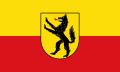
Blazon : "In gold (yellow) a soaring black, red-tongued male."
The coat of arms designed by Fritz Reimann from Fuhrbach was approved by the Lower Saxony Ministry of the Interior on December 5, 1950. The dog is the location known Forecast taken "the Mahnehund" while he is " talking " for the place name. The male is also considered to be a watchful and loyal companion for local farmers and craftsmen.
Description of the flag: "The flag has yellow and red stripes with a coat of arms in the middle."
Culture and sights

St. Andrew's Church
Today's Catholic St. Andrew's Church, which was built between 1867 and 1869 in neo-Gothic style by the Hildesheim architect Wilhelm Daughtermann, is the successor to the Holy Cross Church built before 1800. This was built in the baroque style, but had to be demolished in the following years due to its dilapidation, so that a new building was considered. The St. Andrew's Church is a red sandstone block construction with a transept , a choir closed on five sides and a tower from 1660. In the three-aisled hall, round pillars are set up on which arcades with bud capitals and octagonal bases are located. By backsteinverblendete transverse arches which will groin vault in four yokes divided, consist the transverse arms of one yoke. The gallery of the church rests on five-fold arcades. The side choir walls are adorned with frescoes in the Nazarene style, while the choir and side house windows date from the years 1912 and 1919 and come from the glazier Hubert Henning, who is often active in the lower area . On the main altar you can find a typical picture of the Lower Field altars with the evangelist theme. In addition to this main altar, there are two side altars in the church, for which the Duderstadt sculptor Wilhelm Oppermann was responsible. Other components of the church inventory include a lecture cross from the 16th century measuring 42 by 40 cm and a crescent moon Madonna from the beginning of the 16th century. It is made of lime wood in a baroque setting and is 1.40 m high. Since November 1st, 2014 the church belongs to the parish “St. Sebastian ”based in Rhumspringe.
Tilly oak
On the Hellberg there is an approximately 300 year old oak known as the "Tilly oak". According to local tradition, the tree is said to commemorate the military leader of the Catholic League, Count Tilly .
The Klus
There is a small chapel between Rüderhausen and Duderstadt, which is commonly known as “Die Klus”. It houses a Fatima Madonna and was built after the previous Klus on Klusweg was demolished in 1885.
Economy and Infrastructure
traffic
Rüdershausen is connected to the road network via various highways with the federal road 27 from Göttingen to Herzberg am Harz and the federal road 247 Northeim to Duderstadt .
In the 19th century, Rüdershausen was characterized by the large number of migrant workers who could be found on site. No other place in the Duderstadt district had as many migrant workers as Rüdershausen. About 19.4 percent of all residents were included in this employment. More than half of them worked as a bricklayer . Today there are still a few handicraft and industrial companies in Rüdershausen. These include civil engineering companies, a sawmill, two painting companies, a roofing company and two tiling companies.
Sons and daughters of the church
- Georg Schreiber (1882–1963), science and culture politician, center politician , university professor, papal house prelate , apostolic protonotary , senator of the Max Planck Society, member of the Reichstag for the constituency of North Westphalia from 1920 to 1933
Web links
Individual evidence
- ↑ State Office for Statistics Lower Saxony, LSN-Online regional database, Table 12411: Update of the population, as of December 31, 2019 ( help ).
- ↑ http://wahlen.kds.de/2011kw/Daten/152402_000061/index.html
- ↑ http://wahlen.kds.de/2006kw/Daten/GIE/6_MAIN_E_GEMEINDEWAHL_RUEDERSHAUSEN_2006.html
- ↑ Main statutes of the Rüdershausen community
- ↑ Ewald Heerda: Discoveries in the Eichsfeld. Interesting facts from the woods and fields . Self-published by the author, Heiligenstadt 1993, p. 32 .
Adelebsen | Bad Grund (Harz) | Bad Lauterberg in the Harz Mountains | Bad Sachsa | Bilshausen | Lake Constance | Bovenden | Charging | Dransfeld | Duderstadt | Boar idols | Elbingerode | Friedland | Gieboldehausen | Same | Göttingen | Hann. Münden | Hattorf am Harz | Herzberg am Harz | Hörden am Harz | Jühnde | Krebeck | Landolfshausen | Niemetal | Obernfeld | Osterode am Harz | Jump | Rollshausen | Rosdorf | Rüdershausen | Scheden | Seeburg | Seulingen | Staufenberg | Waake | Walkenried | Wollbrandshausen | Wollershausen | Wulften am Harz
Community-free area in the district of Göttingen
Harz (district of Göttingen)