
Hörden am Harz
| coat of arms | Germany map | |
|---|---|---|

|
Coordinates: 51 ° 40 ′ N , 10 ° 17 ′ E |
|
| Basic data | ||
| State : | Lower Saxony | |
| County : | Goettingen | |
| Joint municipality : | Hattorf am Harz | |
| Height : | 200 m above sea level NHN | |
| Area : | 7.82 km 2 | |
| Residents: | 944 (Dec. 31, 2019) | |
| Population density : | 121 inhabitants per km 2 | |
| Postal code : | 37412 | |
| Area code : | 05521 | |
| License plate : | GÖ , DUD, HMÜ, OHA | |
| Community key : | 03 1 59 020 | |
| Association administration address: | Otto-Escher-Str. 12 37197 Hattorf am Harz |
|
| Website : | ||
| Mayor : | Henning Kunstin ( CDU ) | |
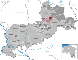
| Location of the municipality of Hörden am Harz in the district of Göttingen | ||
  |
||


Hörden am Harz - located on the Harz - is a municipality in the district of Göttingen in Lower Saxony . It belongs to the joint municipality of Hattorf am Harz , which has its administrative seat in the municipality of Hattorf am Harz . Until August 30, 2003 the community was called Hörden .
Geographical location
Hörden is located immediately southwest of the Upper Harz and Harz Nature Park on the Oder tributary Sieber .
history
The settlement's earliest written record is from 1367 and tells of a "Hinrike van Hornde". The etymology of the name remains speculative. An old Saxon * Hor-ithi would be easy to imagine, which translates as boggy ground .
In 1972 Hörden became part of the Hattorf am Harz municipality.
Since the merger of the districts of Osterode am Harz and Göttingen on November 1, 2016, Hörden am Harz has been part of the district of Göttingen.
Outsourcing
On July 1, 1972, the Düna residential area was ceded to the then district town of Osterode am Harz with slightly more than 100 inhabitants .
Population development
| Hörden am Harz - population development since 1975 | ||||||
|---|---|---|---|---|---|---|
| year | Residents | year | Residents | development | ||
| 1975 | 1024 | 2011 | 1060 |
 |
||
| 1980 | 1063 | 2012 | 1050 | |||
| 1985 | 1053 | 2013 | 1024 | |||
| 1990 | 1085 | 2014 | 1009 | |||
| 1995 | 1118 | 2015 | 993 | |||
| 2000 | 1150 | 2016 | 985 | |||
| 2005 | 1151 | 2017 | 981 | |||
| 2010 | 1108 | |||||
| Source: Years 1975 to 2016 | ||||||
politics
Municipal council
The local council from Hörden am Harz consists of nine (2011: 11) councilors.
(Status: local election on September 11, 2016 )
mayor
In November 2016, the council elected Henning Kunstin (CDU) as the new mayor.
Coat of arms, flag and banner
| Banner, coat of arms and flag | |

|
|

|
|
Blazon : "In blue a golden (yellow) kettle hook that touches the golden (yellow) base of the shield."
By order of May 15, 1979, the Oberkreisdirektor of the then Osterode am Harz district granted the municipality of Hörden permission to use a coat of arms, a seal and a flag. Meaning: The golden bottom and the kettle hook symbolize the rural way of life; the boiler hook is a common heraldic symbol for a home. The kettle hook was used to hang kettles and pots over the open hearth fire.
Description of the flag: "The flag has yellow-blue stripes across the board with the coat of arms shifted towards the pole, up to the dividing line on the yellow stripe, the lower part on the blue stripe."
Description of the banner: "The banner is yellow-blue striped lengthways with a coat of arms above the middle."
Community partnerships
There is a partnership with the Gaggenau district of Hörden in the Black Forest .
Culture
There is a Carnevals Club in Hörden, the HCC. This organizes the annual carnival events.
Sports
In Hörden there is the sports club SV Rot Weiß Hörden and the gymnastics club TV Hörden. There is also the cycling club "Adler" Hörden. The Harzer Keiler Run has been held annually in Hörden am Harz since 2012.
Transport links
It is located near the highway-like federal highway 243 , called Westharzschnellstrasse , which leads from federal highway 7 near Seesen to federal highway 38 near Nordhausen . Via Herzberg or Hattorf you can also quickly reach the federal highway 27 , which leads from the federal highway 7 near Göttingen to the highway-like highway 6 ( north Harz highway ) near Blankenburg .
The closest railway access points are the Herzberg Schloß stop on the western Harz line, the Herzberg (Harz) station on the western and southern Harz line and the Hattorf stop on the southern Harz line.
Web links
- Website of the joint community
- Article Hörden am Harz In: GenWiki.de
Individual evidence
- ↑ State Office for Statistics Lower Saxony, LSN-Online regional database, Table 12411: Update of the population, as of December 31, 2019 ( help ).
- ↑ Uwe Ohainski, Jürgen Udolph : The place names of the district of Osterode (= publications of the Institute for Historical Research at the University of Göttingen . Volume 40 ). Publishing house for regional history, Bielefeld 2000, ISBN 3-89534-370-6 , p. 81–83 ( adw-goe.de [PDF; 2.6 MB ]).
- ^ Federal Statistical Office (ed.): Historical municipality directory for the Federal Republic of Germany. Name, border and key number changes in municipalities, counties and administrative districts from May 27, 1970 to December 31, 1982 . W. Kohlhammer GmbH, Stuttgart / Mainz 1983, ISBN 3-17-003263-1 , p. 216 .
- ↑ Statistical surveys , homepage of the State Office for Statistics and Communication Technology Lower Saxony LSKN-Online ; Population figures on December 31 of each year.
- ^ Website of the Göttingen municipal services , accessed on October 1, 2016
- ^ Council elects Henning Kunstin as the new mayor of Hörden. In: harzkurier.de. November 3, 2016, accessed May 6, 2020 .
- ↑ Coat of arms of the municipality of Hörden am Harz
- ^ Flag of the municipality of Hörden In: kommunalflaggen.de , accessed on May 6, 2020.
- ↑ Entry on the partnerships of the integrated community Hattorf am Harz and its member communities . Accessed on April 21, 2019, 02:18
Adelebsen | Bad Grund (Harz) | Bad Lauterberg in the Harz Mountains | Bad Sachsa | Bilshausen | Lake Constance | Bovenden | Charging | Dransfeld | Duderstadt | Boar idols | Elbingerode | Friedland | Gieboldehausen | Same | Göttingen | Hann. Münden | Hattorf am Harz | Herzberg am Harz | Hörden am Harz | Jühnde | Krebeck | Landolfshausen | Niemetal | Obernfeld | Osterode am Harz | Jump | Rollshausen | Rosdorf | Rüdershausen | Scheden | Seeburg | Seulingen | Staufenberg | Waake | Walkenried | Wollbrandshausen | Wollershausen | Wulften am Harz
Community-free area in the district of Göttingen
Harz (district of Göttingen)