
Or (Rhume)
| Or | ||
 Southwestern Harz with Oder |
||
| Data | ||
| Water code | DE : 48826 | |
| location | District of Goslar , District of Göttingen , District of Northeim , Lower Saxony ( Germany ) | |
| River system | Weser | |
| Drain over | Rhume → Leine → Aller → Weser → North Sea | |
| source | near Oderbrück in the Harz Mountains 51 ° 46 ′ 20 ″ N , 10 ° 33 ′ 58 ″ E |
|
| Source height | approx. 812 m above sea level NHN | |
| muzzle | near Katlenburg in the Rhume coordinates: 51 ° 40 ′ 44 ″ N , 10 ° 6 ′ 11 ″ E 51 ° 40 ′ 44 ″ N , 10 ° 6 ′ 11 ″ E |
|
| Mouth height | approx. 137 m above sea level NHN | |
| Height difference | approx. 675 m | |
| Bottom slope | approx. 12 ‰ | |
| length | 56.1 km | |
| Catchment area | approx. 384.66 km² | |
| Discharge at the Lindau A Eo gauge : 376 km² |
NNQ MNQ 1980/2002 MQ 1980/2002 Mq 1980/2002 MHQ 1980/2002 HHQ |
244 l / s 1.58 m³ / s 6.31 m³ / s 16.8 l / (s km²) 76.8 m³ / s 148 m³ / s |
| Reservoirs flowed through | Oderteich , Oder reservoir | |
| Small towns | Bad Lauterberg | |


The Oder is a 56.1 km long, eastern and right tributary of the Rhume in the districts of Goslar , Göttingen and Northeim in southeastern Lower Saxony ( Germany ). It flows in the Harz and in the southwestern Harz foreland.
geography
course
The Oder rises in the Goslar district in the Upper Harz . Its source is in the Harz National Park around 1.3 km north-north-west of the Achtermannshöhe and around 1 km south-east of Oderbrück , a district of the town of Braunlage . Your in the southern part of the Brockenfeld in the Oderbruch at about 812 m above sea level. The source located at the NHN is called "Odersprung".
The Abbe , Große Bode , Ecker and Kalte Bode rivers have their respective headwaters on the Brockenfeld and thus near the Odersprung ; the triangular post stands on the eastern edge of the Brockenfeld .
After the Oder in Oderbrück has crossed federal highway 4 in an east-west direction, it is dammed for the first time west of the settlement in the Oderteich , where it bends south. Below this reservoir it passes the Rehberg with the Hohe Klippen to the west and the Hahnenkleeklippen to the east . A few kilometers further down the river it flows through the Sankt Andreasberg district of Oderhaus , where the Trutenbeek flows into it. Then it is dammed southwest of the Odertal sawmill , where it leaves the Harz National Park and at the same time flows into the Harz Nature Park , to the Oder reservoir.
After the subsequent confluence of the Sperrlutter , the Oder crosses the core town of Bad Lauterberg and leaves the Harz. In the city, the river bends towards the west after the Lutter flows into it. Then it flows north past Pöhlde , where it leaves the Harz Nature Park, and through Hattorf am Harz , where it takes in the Sieber River coming from the northeast . It passes the Rotenberg ridge to the north and gradually runs through Wulften am Harz .
Finally opens the Oder in Katlenburg coming from the east to about 137 m in the line influx Rhume .
Catchment area and tributaries
The tributaries of the Oder, whose catchment area is about 384.66 km², include (viewed downstream; l = left-hand side; r = right-hand side):
|
|
Localities
Localities on the Oder are:
- Oderbrück (district of Braunlage )
- Oderhaus (district of Braunlage)
- Bad Lauterberg
- Scharzfeld
- Poehlde
- Hattorf am Harz
- Wulften am Harz
- Katlenburg-Lindau
Hydrography
The Oder and its largest tributary, the Sieber, lose water on their way through the southern Harz gypsum karst region to the Rhume spring , located to the south . This was proven by dyeing tests in the course of several hydrological investigations of the Rhume spring, as early as 1910 at Eichelbach near Herzberg by Karl Thürnau (with six kilograms of uranine ), then several times, e.g. in 1980 by the Lower Saxony State Office for Soil Research, at Sieber near Hörden and at Or near Scharzfeld. The large extent of the water losses is mainly explained by the fact that the ridge of the Rotenberg keeps the mighty gravel deposits of the Oder from the valley of the Rhume like a dam, but not the water flowing in the gravel, which flows through the sometimes fissured or karstification- capable rock layers of the Rotenberg can get deeper Rhumequelle.
Despite the water losses, the Oder is the larger, richer river when it flows into the Rhume, i.e. actually the main river. It is noteworthy that a similar situation also exists at the confluence of the Rhume with the Leine and again with its confluence with the Aller . This makes the Oder hydrographically the main river of the Aller river system.
Glacial embossing
During the Pleistocene , the upper reaches of the Oder in particular were shaped by the Harz's own glaciation. From a plateau glacier located between the Bruchberg , the Sonnenberg and the Achtermannshöhe , in the area of the Oderteich, a glacier tongue came down into the valley. In the area below the Hahnenklee cliffs you can still find the clearest traces of the Harz glaciation in the entire mountain range. In addition to several include Endmoränenbögen , Kames and kettle holes also glazifluviale and glaciolimnic sediments. The findings so far all point to the last ice age . Traces of earlier icing phases are no longer visible due to the strong periglacial and warm-time overprinting.
Oderaue nature reserve
Between Scharzfeld and Katlenburg, the Oder flows through the Oderaue nature reserve, which was designated in 2007 and covers around 510 hectares (NSG no. 378334).
water sports
The Oder can be ridden by kayaks and canoes for about 15 km from the crossing under the B 27 to the mouth .
photos

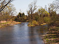
The Oder in Bad Lauterberg

The confluence of the Lutter (l) and the Oder (r) in Bad Lauterberg
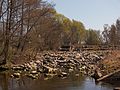
Confluence of the Sieber (l) into the Oder (r) near Hattorf am Harz
Oder weir near Hattorf


Web links
Individual evidence
- ↑ a b c Topographic map : Source ( memento of the original from November 1, 2016 in the Internet Archive ) Info: The archive link has been inserted automatically and has not yet been checked. Please check the original and archive link according to the instructions and then remove this notice. (Odersprung) and mouth ( memento of the original from November 1, 2016 in the Internet Archive ) Info: The archive link was inserted automatically and has not yet been checked. Please check the original and archive link according to the instructions and then remove this notice. (DTK 50/25; heights according to contour lines in AK 5 / 2.5), on natur-erleben.niedersachsen.de
- ↑ a b c d Environmental card service of the Lower Saxony Ministry for the Environment, Energy and Climate Protection ( information )
- ↑ NLWKN : Inventory of the implementation of the EC WFD, Rhume area, Annex Table 2. Accessed on November 1, 2016 . , Göttingen December 2004, accessed on August 3, 2013, from wasserblick.net
- ↑ Duphorn, K .: Was the Upper Harz glaciated in the Pleistocene? (No longer available online.) Formerly in the original ; accessed on December 13, 2017 . ( Page no longer available , search in web archives ) Info: The link was automatically marked as defective. Please check the link according to the instructions and then remove this notice. , Hanover 1968, accessed on December 13, 2017
- ↑ Map services of the Federal Agency for Nature Conservation ( information )