Oderaue (nature reserve)
|
Oderaue nature reserve
|
||
|
NSG Oderaue in Wulften |
||
| location | South of Osterode , in the districts of Northeim and Göttingen in Lower Saxony | |
| surface | 510.0 ha | |
| Identifier | NSG BR 124 | |
| WDPA ID | 378334 | |
| Geographical location | 51 ° 37 ′ N , 10 ° 17 ′ E | |
|
|
||
| Setup date | April 11, 2007 | |
| administration | NLWKN | |
| particularities | Overlay with FFH area No. 134 Sieber, Oder, Rhume (505.4 ha) | |
The Oderaue is a nature reserve in the Lower Saxon town of Herzberg am Harz and the communities of Hattorf am Harz and Wulften am Harz in the joint community of Hattorf am Harz in the district of Göttingen and the community of Katlenburg-Lindau in the district of Northeim .
The nature reserve with the registration number NSG BR 124 is 510 hectares in size. 392 hectares of this are in the Göttingen district and 118 hectares in the Northeim district. The nature reserve is almost completely part of the FFH area “Sieber, Rhume, Oder”. In the west it borders on the nature reserve " Rhumeaue / Ellerniederung / Gillersheimer Bachtal " nature reserve . The area has been a nature reserve since April 26, 2007. Responsible lower nature conservation authorities are the districts of Göttingen and Northeim.
The nature reserve is located southwest of the Harz Mountains and extends from Scharzfeld on the city limits of Herzberg am Harz and Bad Lauterberg in the Harz Mountains to the mouth of the Oder and Rhume in Katlenburg . The eastern area up to the state road 530 near Pöhlde lies within the Harz nature reserve .
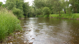
The nature reserve protects the natural course of the Oder and its floodplain as well as the adjacent slopes of the Oderberg near Scharzfeld. The largely unpaved river course, which partially runs through the southern Harz Zechstein belt, has strongly structured bank areas, extensive gravel banks and islands as well as numerous flood channels and tributaries. The course of the river is regulated by weirs in several places . Typical karst phenomena such as shrinkage and sinkholes occur in the area of the southern Harz Zechstein belt . In particular, between Scharzfeld and Pöhlde, the water of the Oder sinks underground, so that the river in this area sometimes dried up in dry years, especially before the construction of the Oder dam in the Harz Mountains . The water of the Oder, which sinks here, reappears in the Rhume spring .
In the nature reserve, the Oder is often accompanied by structurally rich floodplain and swamp forests with a high proportion of old and dead wood, as well as deciduous and mixed forests . In addition, tall herbaceous vegetation , reed beds and willow bushes are widespread on moist locations , and ruderal fields and poor grassland on dry locations . On the slope areas of the Oderberg near Scharzfeld, which are included in the nature reserve, near-natural forests are growing, which are not managed for forestry as a compensatory measure for the construction of the federal road 243n .
In the floodplain area of the Oder there are numerous ponds, mostly created by gravel mining, some of which are included in the nature reserve.
Web links
- "Oderaue" nature reserve in the database of the Lower Saxony State Office for Water Management, Coastal and Nature Conservation (NLWKN)


