Stadtwald Göttingen and Kerstlingeröder Feld
|
Stadtwald Göttingen and Kerstlingeröder Feld
|
||
|
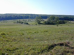
View over the Kerstlingeröder field to the Göttingen city forest |
||
| location | east of Göttingen-Herberhausen , Lower Saxony | |
| surface | 1,193 ha | |
| Identifier | NSG BR 125 | |
| WDPA ID | 378087 | |
| FFH area | 1,193 ha | |
| Bird sanctuary | 73.0 ha | |
| Geographical location | 51 ° 33 ' N , 10 ° 2' E | |
|
|
||
| Sea level | from 306 m to 444 m | |
| Setup date | May 7, 2007 | |
| administration | NLWKN | |
The nature reserve Stadtwald Göttingen and Kerstlingeröder Feld has a size of 1193 hectares and is located in the natural area " Weser and Leinebergland " in southern Lower Saxony. It was established in 2007 and represents part of the largest contiguous lime-beech forest complex within this region.
Habitats
The nature reserve is located in the Göttingen Forest and is primarily characterized by the woodruff beech forest. The rare orchid-lime-beech forest as well as remnants of the oak-hornbeam forest and isolated alder-ash spring forest areas also occur to a lesser extent . Particularly worthy of protection is the structural wealth with a high proportion of dead and old wood , which is influenced by three natural forest areas in the area of the Göttingen city forest . Occasionally there are shallow, partially swampy or with small still waters or ponds filled sinkholes and rare limestone tufa springs and corridors.
Within the forest complex lies the “ Kerstlingeröder field ”, which is around 200 hectares in size . This open land area as a relic of an old cultural landscape was already settled in the Middle Ages and was farmed for a long time. From 1928 to 1992 it was used as a military training area. After that, the open spaces were subject to natural succession, which today is largely held back by suitable maintenance measures. The grassland areas that predominate here are used to varying degrees. The poor, lowland hay meadows and poor pastures rich in limestone, which are rare in Lower Saxony, are particularly valuable, as are their submontane features with golden oats. Chance have dry warm locations occurring Ruderalfluren transitions to saumartenreichen lime lean lawn on. The green areas are subdivided by bushes and field trees as well as distinctive individual trees or groups of trees.
animals and plants
The aim of protecting and developing the various biotopes is to preserve habitats for various animal and plant species.
In mammals are the wild cat and bats , in birds backed Shrike , Wryneck , Middle Spotted Woodpecker , Gray-headed Woodpecker and Red Kite , in insects Polypore large insects and endangered butterflies and amphibians in the great crested newt .
In the summer of 2013, the nature reserve in the north was connected to the neighboring forests with a green bridge over the B 27 for around 2.6 million euros, in particular to protect the wildcat .
The green fork -tooth moss ( Dicranum viride ), the earth chestnut and common fringed gentian , German gentian , slit-leaved grove buttercup , alpine ziest , gold clover and Geneva Günsel are named as plants particularly worthy of protection in the ordinance on the nature reserve .
Geographical location
The nature reserve is located east of the urban area of the Lower Saxon city of Göttingen , south of the B 27 between Herberhausen , Roringen , Waake , Mackenrode and Groß Lengden . The 428 m high Mackenröder peak represents an eastern border point. 1018 ha of the nature reserve are in the FFH area “Göttinger Wald” (No. 138) and 73 ha in the EU bird sanctuary “Unteres Eichsfeld” (V19). In places it borders on parts of the " Göttinger Wald " nature reserve .
administration
The nature reserve is registered with the Lower Saxony State Agency for Water Management, Coastal and Nature Conservation (NLWKN) under the registration number NSG BR 125 . The CDDA code (central database for designated areas) of the EEA ( European Environmental Agency ) is 378087. Responsibility for the nature reserve lies with the lower nature conservation authority of the city of Göttingen.
Individual evidence
- ↑ Construction of a green bridge over the B 27 between Roringen and Waake. on the website of the Lower Saxony State Authority for Road Construction and Transport (accessed on August 29, 2013)


