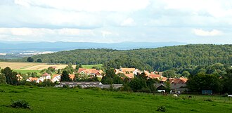
Mackenrode (Landolfshausen)
|
Mackenrode
Community Landolfshausen
|
|
|---|---|
| Coordinates: 51 ° 31 '48 " N , 10 ° 3' 51" E | |
| Height : | 270 m |
| Residents : | 288 (Jun. 2008) |
| Incorporation : | 1st January 1973 |
| Postal code : | 37136 |
| Area code : | 05507 |
Mackenrode is a district of the southern Lower Saxony municipality of Landolfshausen in the district of Göttingen . The town with around 290 inhabitants is located directly east of the Göttingen Forest , below the Mackenröder peak , about eight kilometers east of Göttingen .
history
The village is considered to be the oldest “rode” place in the Göttingen district. Mackenrode was first mentioned as Makkenrod in a document from Emperor Otto II dated June 7, 973 , in which he confirmed the rights of the Marienkloster .
On January 1, 1973, Mackenrode was incorporated into the Landolfshausen community.
literature
- Erwin Steinmetz: The millennial Mackenrode . 1973.
- Bodo Neumann: Mackenrode, Göttingen district . 2012.
Individual evidence
- ^ Regesta imperii II Saxon House (919-1024) - II, 2 Otto II. (955) 973-983, ed. Hanns Leo Mikoletzky 1950, p. 278
- ^ Federal Statistical Office (ed.): Historical municipality directory for the Federal Republic of Germany. Name, border and key number changes in municipalities, counties and administrative districts from May 27, 1970 to December 31, 1982 . W. Kohlhammer GmbH, Stuttgart / Mainz 1983, ISBN 3-17-003263-1 , p. 208 .


