
Hattorf am Harz
| coat of arms | Germany map | |
|---|---|---|

|
Coordinates: 51 ° 39 ' N , 10 ° 14' E |
|
| Basic data | ||
| State : | Lower Saxony | |
| County : | Goettingen | |
| Joint municipality : | Hattorf am Harz | |
| Height : | 176 m above sea level NHN | |
| Area : | 29.19 km 2 | |
| Residents: | 4004 (Dec. 31, 2019) | |
| Population density : | 137 inhabitants per km 2 | |
| Postcodes : | 37197, 37434 | |
| Area code : | 05584 | |
| License plate : | GÖ , DUD, HMÜ, OHA | |
| Community key : | 03 1 59 018 | |
| LOCODE : | DE HRZ | |
| Address of the municipal administration: |
Otto-Escher-Str. 12 37197 Hattorf am Harz |
|
| Website : | ||
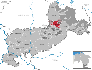
| Location of the municipality of Hattorf am Harz in the district of Göttingen | ||
  |
||

Hattorf am Harz is a municipality in the district of Göttingen in Lower Saxony ( Germany ). It is the administrative seat of the combined community of Hattorf am Harz with the communities Elbingerode , Hattorf am Harz, Hörden am Harz and Wulften am Harz .
geography
.jpg)
Hattorf am Harz is located on the southwestern edge of the Harz Mountains or on the north of the Rotenberg and is traversed in an east-west direction by the Oder , into which the Sieber, coming from the northeast, joins within the village .
history
In 952 the community was first mentioned in a document of the Pöhlde monastery : King Otto I the Great confirmed the foundation of the Pöhlde monastery in a document and gave it "tertiam partem villae Hattorpp" ("the third part of the village of Hattorpp") . After the death of the last Saxon emperor Lothar III. Konrad, the Duke of Franconia, was elected the new German King in 1138, thus establishing the Hohenstaufer dynasty. In 1157, Emperor Friedrich I Barbarossa enfeoffed his cousin Heinrich the Lion with the office and Herzberg Castle, which was the beginning of the rule of the Welfs for Hattorf , which lasted until 1866. Later there was a family based in Hattorf, called the Lords of Hattorf . However, not much is known about them. All we know is that on November 29, 1312 in a document from the Jacobi monastery in Osterode, a knight named Gunzelin Letgast sold the brothers Werner and Eckbert von Hattorf a meadow called "Viehtrift" for a mark. This meadow is located in the Hattorfer Feldmark. The progenitor of these gentlemen was also called Eckbert von Hattorf and was first mentioned in a document in 1241. He had two sons, Eckbert and Conrad von Hattorf, they are called in 1263 and 1296. Eckbert was a knight and often stayed with Duke Heinrich von Braunschweig , but his brother Conrad was employed as a lawyer at Grona Castle near Göttingen . Conrad the Younger and Eckbert are named as Conrad's sons. Conrad held the rank of "sacerdos" ( priest ) and his brother Eckbert that of "miles" ( knight ). Both appear as witnesses in notarizations in 1304 and 1332. The lords' residence was a castle on the hill opposite the Petersberg. During excavations and excavations, fire debris and other smaller artifacts were found several times. A "Pipesburgk" is also mentioned in the early church registers, this could be related to the Old High German and English expression "to peep" - to look out.
The family of the Lords of Hattorf got lost in the later centuries; only in the 18th and 19th centuries did the gentlemen von Hattorf appear again.
Since the merger of the districts of Osterode am Harz and Göttingen on November 1, 2016, Hattorf am Harz has been part of the district of Göttingen.
The medieval desert areas of Barkevelde , Oy and Varenbroke are in the vicinity of Hattorf .
Population development
| Hattorf am Harz - population development since 1975 | ||||||
|---|---|---|---|---|---|---|
| year | Residents | year | Residents | development | ||
| 1975 | 4002 | 2011 | 4197 |
 |
||
| 1980 | 4006 | 2012 | 4141 | |||
| 1985 | 4176 | 2013 | 4122 | |||
| 1990 | 4273 | 2014 | 4090 | |||
| 1995 | 4343 | 2015 | 4074 | |||
| 2000 | 4476 | 2016 | 4066 | |||
| 2005 | 4429 | 2017 | 4050 | |||
| 2010 | 4295 | |||||
| Source: Years 1975 to 2016 | ||||||
religion
Most of the inhabitants of Hattorf belong to the Evangelical Lutheran parish. The church of St. Pankratius (see culture and sights) on Kirchstrasse, the neighboring cemetery and the kindergarten on Gebrüder-Grimm-Platz belong to it . The parish belongs to the parish of Herzberg.
The Catholic Church of St. Hildegard was named after Hildegard von Bingen . In 1945/46 refugees and displaced Catholics settled in Hattorf and the surrounding areas, and on October 12, 1958 the foundation stone for the church on Rotenbergstrasse was laid. On September 12, 1959, the church was consecrated by Bishop Heinrich Maria Janssen . Since November 1st, 2006 the church belongs to the parish of St. Josef in Herzberg , the parish of Hattorf am Harz was dissolved in this context.
politics
Municipal council
The municipal council consists of 15 councilors (changes from 2011).
(Status: local election on September 11, 2016 )
coat of arms
| Banner, coat of arms and flag | |

|
|

|
|
Blazon : "On a silver background a red kite (forked harrier) with golden reinforcement, sweeping right along, holding a blue gear with two green ears of wheat stuck through it."
The coat of arms designed by Alfeld Orlovius was approved by the Lower Saxony Minister of the Interior on May 28, 1952. On the occasion of the millennium, a completely new coat of arms was created and in this the village life and the local economic structure should be visually combined. According to the strict heraldic rules, only certain shapes and colors are allowed. The permitted colors are red, blue, green and black as well as the two "metals" gold and silver (as colors yellow and white). To get a new coat of arms a competition was decided with the aim of collecting new designs. However, this led to little success, so the council of the village went to Alfeld to the heraldist Alfeld Orlovius, where these symbols of the coat of arms were finally chosen:
- The gear wheel as a symbol for the economy
- The ears of wheat as symbols for the agriculture of the village
- The red kite symbolizes the nature of the area.
Flag and banner
Description of flag and banner: "Flag and banner are white with the symbols of the coat of arms in the middle or above the middle (swallowtail banner)."
Town twinning
Culture and sights

church
With its seven meters diameter and a height of 10.5 meters, the church tower of Hattorf was most likely part of the former castle of the Lords of Hattorf, which is attested in the 13th and 14th centuries and is mentioned under the name Pipesborg . A spur system over the mouth of the Sieber into the Oder also indicates the old castle. It presents itself as a well-fortified round building, has walls that are up to 1.5 m thick and were built up from coarse gravel, as well as light slits that are reminiscent of earlier loopholes . The nave is built onto the tower in half-timbering and hung with slate panels. It dates from the years 1755/1756 and had an older predecessor, which is dated to the 15th century.

Wilhelm Busch Memorial
The Wilhelm Busch Memorial commemorates the poet and draftsman Wilhelm Busch (1832–1908).
Economy and Infrastructure
traffic
Hattorf am Harz is in the immediate vicinity of federal highway 27 , which leads from Göttingen in the direction of Braunlage . Hattorf can also be reached via federal highway 243 . In addition, Hattorf, with its own train station, is located directly on the southern Harz line between Göttingen (or Northeim ) and Nordhausen .
Sons and daughters of the church
- Friedrich Busse (1794–1862), railway director in Leipzig and inventor of various improvements in railway traffic; is considered the father of the German railways
- Carl Heinz Wienert (1923–1963), painter
- Heinrich Graefenstein (1936–1999), designer and photographer
- Burkhard Rost (* 1961), scientist, Technical University of Munich
literature
- Norbert Janetzke: Village and Modernity. Rural world between tradition and change since the 18th century. On the history of the community of Hattorf am Harz . Jacobs, Lage 2004, ISBN 3-89918-132-8
- Hermann Böttcher: Hattorf am Harz. Contributions to local history . Mecke, Duderstadt 2002, ISBN 3-932752-88-0
Web links
- Official website
- Integrated community of Hattorf am Harz
- Private page about Hattorf
- Article Hattorf am Harz In: GenWiki.de
Individual evidence
- ↑ State Office for Statistics Lower Saxony, LSN-Online regional database, Table 12411: Update of the population, as of December 31, 2019 ( help ).
- ↑ Statistical surveys , homepage of the State Office for Statistics and Communication Technology Lower Saxony LSKN-Online ; Population figures on December 31 of each year.
- ↑ https://wahlen.kdgoe.de/2016kw/Daten/159403_000042/index.html
- ↑ Main statutes of the municipality of Hattorf am Harz
- ↑ Entry on the partnerships of the integrated community Hattorf am Harz and its member communities . Accessed on April 21, 2019, 02:18
Adelebsen | Bad Grund (Harz) | Bad Lauterberg in the Harz Mountains | Bad Sachsa | Bilshausen | Lake Constance | Bovenden | Charging | Dransfeld | Duderstadt | Boar idols | Elbingerode | Friedland | Gieboldehausen | Same | Göttingen | Hann. Münden | Hattorf am Harz | Herzberg am Harz | Hörden am Harz | Jühnde | Krebeck | Landolfshausen | Niemetal | Obernfeld | Osterode am Harz | Jump | Rollshausen | Rosdorf | Rüdershausen | Scheden | Seeburg | Seulingen | Staufenberg | Waake | Walkenried | Wollbrandshausen | Wollershausen | Wulften am Harz
Community-free area in the district of Göttingen
Harz (district of Göttingen)