
Charges
| coat of arms | Germany map | |
|---|---|---|

|
Coordinates: 51 ° 29 ' N , 9 ° 41' E |
|
| Basic data | ||
| State : | Lower Saxony | |
| County : | Goettingen | |
| Joint municipality : | Dransfeld | |
| Height : | 285 m above sea level NHN | |
| Area : | 13.99 km 2 | |
| Residents: | 524 (Dec. 31, 2019) | |
| Population density : | 37 inhabitants per km 2 | |
| Postal code : | 37127 | |
| Area code : | 05502 | |
| License plate : | GÖ , DUD, HMÜ, OHA | |
| Community key : | 03 1 59 008 | |
| Address of the municipal administration: |
Oberdorfstrasse 5 37127 Bühren |
|
| Website : | ||
| Mayor : | Christoph Witzke (independent) | |
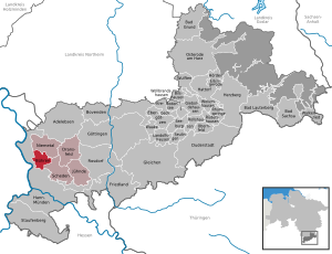
| Location of the municipality of Bühren in the district of Göttingen | ||
  |
||

Bühren is a municipality in the district of Göttingen in Lower Saxony, belonging to the Dransfeld joint municipality .
geography
location
Bühren lies between Hann. Münden in the southwest and Dransfeld in the northeast. The village on the eastern edge of the Bramwald in the Münden Nature Park is traversed by the upper reaches of the Schede , the source of which is southwest of the village.
history
The time of the establishment of the place "Bühren vor dem Wald" is unknown. Archaeological finds of ceramics and the Vossküppel quartzite strike show that the site, which is favorably located in terms of settlement topography, was visited as early as the Paleolithic and later settled, because the site was on the eastern slope of the Bramwald, protected from flooding and yet directly on the water-rich Schede. However, it is not certain since when one can assume a continuous settlement of the village. In the 9th and 10th centuries it was mentioned several times as Burian in the Corveyer traditions, making it over 1000 years old. The assignment of these documents to Bühren is not without controversy, as there were or still are several places called Büren in the wider area.
In the Middle Ages, an important trade route, the Harster Heerweg, passed the village in the immediate vicinity. The church and tie, which still form the cultural center today, date from this time. Since the territorial reform of January 1, 1973, until where it was part of the Münden district, Bühren has been the smallest independent municipality in the Dransfeld joint municipality .
politics
Municipal council
The municipal council in Bühren consists of 9 councilors, including the part-time mayor.
| Common Fees List (GLB) | total | |
| 2016 | 9 | 9 seats |
(Status: local election on September 11, 2016 )
Culture and sights
religion
Until December 31, 2010, Bühren was the seat of an Evangelical Lutheran parish. On January 1, 2011, it was merged with the St. Michaelis parish in Niemetal to form the Evangelical Lutheran St. Michaelis parish in Niemetal-Bühren, based in Niemetal.
Cultural and natural monuments

church
The Bühren Church goes back to a roughly square original building from the middle of the 12th century. The two-storey structure had a semicircular apse in the east and a tower was added to the west around 1220. The ground floor, which is covered with a barrel vault, and the few wall slits on the lower floors show the originally defensive character of the tower; on the top floor there are Romanesque coupled sound openings. After 1308 the Romanesque apse was replaced by a slightly retracted rectangular choir. The two bells in the church also date from the Middle Ages. The current late baroque shape of the nave and the tower roof come from renovations in the 18th century.
Tie

The medieval Tie , together with the church located around 40 meters to the west and the surrounding half-timbered buildings, form the center of Bührens. The square, now surrounded by eleven linden trees, was used in its beginnings for the administration of village justice, in 1887 it was also mentioned as a meeting place, the last meeting is said to have taken place here in 1948. The tie, which is placed on a natural hill, is surrounded by a dry stone wall, and in the middle there is a stone table of unknown age resting on three supporting stones. In the course of road construction measures in the 1920s, the square was redesigned from a round shape to a slightly oval shape with a diameter of 17 to 20 meters. In 1960/61 the four entrances were slightly relocated, the damaged dry stone wall was added, the linden trees were replanted and three bell-cast pits were dug. Because the older bell of the church is dated to before 1350 based on comparisons, a corresponding minimum age is also assumed for the tie.

Stone marks
To the southwest of the village, on a hill on the Teichberg, is the Bührener Kreuzsteinnest , a group of ten cross stones as a stone cross nest , which are unique in this cluster in northern Germany. Nine of these cross stones were mentioned in writing as early as 1878 with reference to the formation of legends, and field names in maps from 1785 and 1840 also refer to the cross stones at this point. The current design of the square goes back to a backfill from 1954/55, when the cross stones were regrouped with concrete foundations. In 1956, another half-disc cross stone was added to the group. The two stone crosses and eight cross stones show different cross representations in relief and incision technique, two of them also further representations (shuttle or hatchet and block). The stones show different degrees of destruction, in some cases the cross shapes are no longer recognizable. According to a legend, the nuns of the Hilwartshausen monastery (10th to 16th centuries) performed prayer exercises at the Bührener Kreuz when they passed there on the way to Gladbeck.
About 170 meters south of the Kreuzenstein group was discovered in 1953, the lower half of the so-called "Männekensteines" in situ , the amount still is about 40.5 cm today. The "Mannekenstein" is dated to the end of the 12th century; it consists of a sandstone slab and has the base of a cross shaft as an incision in the center of the face. On the left edge of the stone a man dressed in a pleated skirt is depicted with his hands on his hips. A lance stuck in the ground to his left. Such decorations wore memorial stones, which are known as "tituli", and which were set up for fallen soldiers.
Archaeological sites
The Vossküppel , 1 km northwest of Bühren, is an archaeological site for the early manufacture of tools from quartzite . Excavations carried out by FB Jünemann in the 1950s revealed filled excavation pits with splits and unsuccessful equipment. In the vicinity, fragments of a vessel made of corded ceramics were found, and there are two groups of barrows in the vicinity that were assigned to the earlier Bronze Age.

Behren organ pipes
The basalt columns of the Bührener organ pipes are a natural monument .

Circular hiking trails
Two circular hiking trails start from the tie in the center of the village:
- Bühren culture path: It is 2.5 km long. The aim is to raise awareness of the objects of natural and cultural history in and around Bühren on a circular route with different stations. There are signposts and information boards there. The route is marked by arrows.
- From Bühren through the cultural landscape in the southern Bramwald: Landscape, culture and monuments in and around the Bramwald tell their story on a 12.5 km long circular hike. The varied landscape with the Bramwald reveals its peculiarities in many places.
literature
- Ernst Andreas Friedrich : The cross stone nest of Bühren. In: If stones could talk. Volume I, Landbuch-Verlag, Hanover 1989, ISBN 3-7842-0397-3 , pp. 173-174.
- Joachim von Stockhausen: Dankelshausen - Wellersen between Göttingen and Hann. Münden. A foray into the history of the village and the family. Disserta Verlag, Hamburg 2014, ISBN 978-3-95425-796-6 .
Web links
Individual evidence
- ↑ State Office for Statistics Lower Saxony, LSN-Online regional database, Table 12411: Update of the population, as of December 31, 2019 ( help ).
- ↑ Municipal council on the website of the municipality of Bühren, accessed on January 10, 2017
- ^ Church official gazette for the Evangelical Lutheran Regional Church of Hanover 2/2011, p. 99f.
- ^ A b Peter Ferdinand Lufen: District of Göttingen, part 1. Altkreis Münden with the communities of Adelebsen, Bovenden and Rosdorf . In: Christiane Segers-Glocke (Hrsg.): Monument topography Federal Republic of Germany. Architectural monuments in Lower Saxony . tape 5.2 . CW Niemeyer, Hameln 1993, ISBN 3-87585-251-6 , p. 107 f .
- ↑ Heimatfreunde Bühren, Münden Nature Park eV: Tie cultural monument . Information board at Tie in Bühren
- ↑ a b c Adrianne Hahner: Bühren - Church, Tie, Kreuzsteine, "Mannekenstein". In: Klaus Grote , Sven Schütte (editor): City and District of Göttingen (= Guide to archaeological monuments in Germany. Volume 17). Konrad Theiss Verlag, Stuttgart 1988, ISBN 3-8062-0544-2 , pp. 180-186.
- ↑ Fees. In: suehnekreuz.de. Retrieved May 23, 2020 .
- ↑ O. Höckmann: Paleolithic quartzite strike place and Bronze Age burial mound group on Vossküppel near Bühren. In: Göttingen and the Göttingen Basin. (Guide to prehistoric and early historical monuments, Volume 16), Verlag Philipp von Zabern, Mainz 1970, pp. 149–152.
Adelebsen | Bad Grund (Harz) | Bad Lauterberg in the Harz Mountains | Bad Sachsa | Bilshausen | Lake Constance | Bovenden | Charging | Dransfeld | Duderstadt | Boar idols | Elbingerode | Friedland | Gieboldehausen | Same | Göttingen | Hann. Münden | Hattorf am Harz | Herzberg am Harz | Hörden am Harz | Jühnde | Krebeck | Landolfshausen | Niemetal | Obernfeld | Osterode am Harz | Jump | Rollshausen | Rosdorf | Rüdershausen | Scheden | Seeburg | Seulingen | Staufenberg | Waake | Walkenried | Wollbrandshausen | Wollershausen | Wulften am Harz
Community-free area in the district of Göttingen
Harz (district of Göttingen)