Bovenden
| coat of arms | Germany map | |
|---|---|---|

|
Coordinates: 51 ° 35 ' N , 9 ° 55' E |
|
| Basic data | ||
| State : | Lower Saxony | |
| County : | Goettingen | |
| Height : | 139 m above sea level NHN | |
| Area : | 63.66 km 2 | |
| Residents: | 13,651 (Dec. 31, 2019) | |
| Population density : | 214 inhabitants per km 2 | |
| Postal code : | 37120 | |
| Primaries : | 0551, 05593, 05594 | |
| License plate : | GÖ , DUD, HMÜ, OHA | |
| Community key : | 03 1 59 007 | |
| Address of the municipal administration: |
Rathausplatz 1 37120 Bovenden |
|
| Website : | ||
| Mayor : | Thomas Brandes ( SPD ) | |
| Location of the municipality of Bovenden in the district of Göttingen | ||
The Flecken Bovenden is a municipality in the district of Göttingen in southern Lower Saxony (Germany). Large areas of today's Bovenden area coincide with the earlier "Herrschaft Plesse".
The term stains is an official part of the name. The spot consists of the core town of Bovenden and seven other districts. Around 14,000 residents have their main or secondary residence in the Bovenden area, 48 percent of which live in the core town of Bovenden.
geography
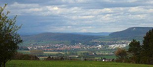
Bovenden is located on the northwestern foothills of the Göttingen Forest and the southwestern foothills of the Nörten Forest about 6 km north of Göttingen . The core town of Bovenden is located between the Osterberg and the Keuperrücken der Lieth in the valley of the Leine, which runs in a south-north direction . On the eastern bank of the turn in the same direction , which joins the Leine a few kilometers further north. Above or east of the Eddigehausen district are the ruins of the medieval Plesse Castle .
Spot breakdown
- Billingshausen
- Bovenden, core town
- Eddigehausen
- Emmenhausen
- Harste
- Lenglern
- Reyershausen
- Spanbeck
Local devastation
In addition to the existing villages, the following places belonged to Bovenden, but they fell into desolation in the late Middle Ages.
- Rodershausen or Rodershusen (2 km northwest of Bovenden)
- Aspe or Aspa (1 km northeast of Spanbeck)
- Botleveshusen (0.2 km west of Mariaspring)
- Backenhusen (1.2 km east of Reyershausen)
- Sturmbeke or Stumbeke (0.9 km west of Reyershausen)
history
The first written mention of the place Bovenden is handed down in a document from Otto the Great dated February 2, 949, in which the future emperor notarised an exchange deal with the Hersfeld monastery . The place name there was Bobbenzunon and is later passed down as Bobbantun (1141, forgery of the 13th century), Bobentun (1170) and Bobentum (1191), since the 13th century as Boventen and since the end of the 16th century in its current form. The derivation of the name is still controversial, an interpretation as a composition of a personal name Bovo, Bob (b) o with the ending -tun (the ending "-tun" stands for "fence, enclosure", also "fenced area" - hence also the English "town"), ie a enclosed settlement founded or ruled by Bobo. Another interpretation is not based on a personal name, but rather from the tribe bioðan (= "above", cf. Low German boven ), i.e. an enclosed settlement above the floodplain of the Leine.
The noble landlord family of the Lords of Boventen appear for the first time in the 12th century , the earliest mention of which in a document dates from 1170. In this document, which concerns donations in the vicinity of Bovenden to the Helmershausen monastery, a Bodo von Boventen is listed in a number of witnesses, from 1211 onwards the Lords von Boventen appear as patrons of the local chapel. In the following decades, the von Boventen family managed to expand their estates, so that by the middle of the 13th century they already owned extensive property in the wider area, but their main town remained Bovenden, where they had seven farms, 11½ Hufen land, and two meadows and had their castle. Outside of their home town they appeared as castle men on the Hardenberg , were in the service of Mainz and were often witnesses to the Hardenbergers . The proximity to Kurmainz not prevented the from Bovenden also fief of Guelph assumptions. In the 14th century they moved more and more to the Braunschweig camp, for example knight Günther von Bovenden vowed to assist Duke Otto von Braunschweig in 1364 against everyone except the Archbishop of Mainz, and if Duke Otto left their alliance with Kurmainz free to serve only him. For two centuries, the Lords of Boventen had a decisive influence on the fortunes of the place, until they gradually lost importance from the end of the 14th century. Only one line, that to Lenglern, continued the name after 1500. The possessions of the Lords of Boventen, referred to in documents as nobiles and miles , were transferred to the noblemen of Plesse. In the Bovender coat of arms, the key today reminds of the Mainz office of the Burgmannen on the Hardenberg.
The Lords of Plesse have been the most important landowners in Bovenden since the 14th century . On October 28, 1447, they gave their entire property to Landgrave Ludwig I of Hesse and received it back from him as an inheritance . In this way, they were able to maintain a higher degree of self-determination compared to the Duchy of Braunschweig-Lüneburg . After the Plessians died out in 1571, the rule of Plesse fell to the Landgraviate of Hessen-Kassel and was now a Hessian enclave. Since the 16th century, Bovenden, the most important place of the Plesse rulership, has also been given more rights: Johannes Letzner first referred to it as a stain in 1587, which at least indicates a market right , and in 1605 the brewing right was granted.
After the abandonment of Castle Plesse in 1660, Bovenden became the administrative seat, a new office building was built from 1777 as a representative baroque complex on the site of two former Meierhöfe of the Steina monastery. Representative and administrative tasks were carried out in this Hessian castle until 1815, it also served as the hunting lodge of the Landgraves of Hesse-Rotenburg . The location as an enclave offered various professions special development opportunities. The Bovenden State Forestry Office has been housed in the building since 1860, and until 1859 it served as the administrative headquarters of the Hanoverian Office of Bovenden, which was then dissolved .
When the Georg-August University in Göttingen was founded, Bovenden also experienced an economic boom from the second half of the 18th century. Many students came to the place, which at that time was still an enclave of the Landgraviate of Hessen-Kassel , to watch theater groups traveling there, to dine in the tavern “To the last Heller” and in the excursion restaurant Mariaspring or to enjoy wine, brandy, coffee and sugar to cover, which were provided with a luxury tax in Göttingen . In the course of these events, which according to the authorities of the Göttingen University were viewed as a waste of time, debauchery and debts on the part of the students, one spoke of the "Bovender danger".
In the context of local and municipal reform on 1 January 1973, the eight were villages Eddigehausen, Emmen Hausen, Harste Lenglern, Upper Billingshausen, Reyershausen, Spanbeck and previously in the district of Northeim located under Billingshausen in spots Bovenden incorporated.
Population development
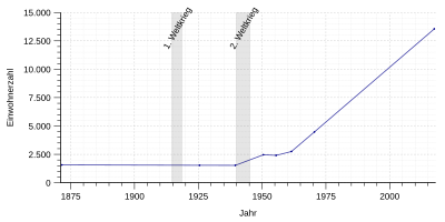
Development of the inhabitants of Bovenden. Before the incorporation in 1973, the number of today's core location is given:
| year | 1871 | 1925 | 1939 | 1950 | 1955 | 1961 | 1970 | 2017 | 2018 |
|---|---|---|---|---|---|---|---|---|---|
| Residents | 1572 | 1537 | 1531 | 2460 | 2409 | 2748 | 4476 | 13,559 | 13,586 |
politics
Municipal council
The municipal council consists of 30 council members, who have been distributed among the individual parties and electoral associations as follows since the municipal elections on September 11, 2016 :
| Party / list | Seats |
|---|---|
| SPD | 13 |
| CDU | 8th |
| FWG | 4th |
| Green | 3 |
| FDP | 1 |
| ALFA | 1 |
mayor
Thomas Brandes ( SPD ) has been the mayor of Bovenden since 2014 .
coat of arms
| Blazon : "The coat of arms of the municipality shows a blue key placed upright in a yellow field, beard pointing to the left, overlaid with a lying red wall anchor." | |
| Justification of the coat of arms: The wall anchor refers to the coat of arms of the noble lords of Plesse , who owned the Plesse rulership until they died out in 1571. In the earliest form of their coat of arms, they already had a transverse double red house anchor on a gold shield. Those two colors have been preserved in the municipal coat of arms to this day. The upright blue key refers to the coat of arms of the Lords of Boventen who used to live in the village . Her shield was split in blue and silver with a gold or silver lion on the front, while the background contained a black wooden key. The helmet on top of the coat of arms showed a blue and silver open flight or two diagonally crossed black keys. Today's municipal coat of arms took over the key in blue and thus picks up on one of the basic colors of the coat of arms of the Lords of Boventen. |
Culture and sights
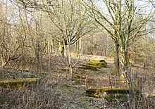
There is an extensive hiking trail in the Lohberg area. On the ridge of the Lohberg there is also the former Jewish cemetery , stretched over a length of approx. 300 m, which was laid out around the year 1680 and on which 65 tombstones can still be found today. The oldest date from the 1770s and 1780s, while the youngest date back to 1926. Although there are parcels of land in Bovender Feldmark with the name Im Judengrund , first mentioned in 1571, and named by the Jew Kirchoff in 1605, there is no evidence of a previous cemetery at either of the two locations. Until it was demolished in 1845, further evidence of Jewish life in Bovenden was provided by a mikveh , which was located behind the house at Unteren Straße 74, as well as a former rear building, which served as a synagogue and schoolhouse and was located at 19 Breiten Straße however, sold in 1922 and canceled in 1960.
Bovenden is on the Solling-Harz-Querweg . Furthermore, there are many sporting activities such as a sports center, tennis courts, a tennis hall, a bowling center and a tournament area with a riding hall.
The yew forest on the Hainberg , directly east of the core town of Bovenden and south of the Eddigehausen district, is one of the largest natural residual occurrences of the European yew in Germany. The habitat is classified as a natural monument and is easily accessible via the hiking trails below the Plesseburg.
The Bovenden transmitter is located on the Osterberg (approx. 350 m) south of Eddigehausen .
The community of Bovenden is part of the German Fairy Tale Route , which leads from Hanau via Bovenden to Bremen.
Economy and Infrastructure
education
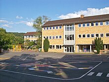
Elementary school on the Sonnenberg
The elementary school on the Sonnenberg is one of the two schools in Bovenden. With the laying of the foundation stone for its building on October 28, 1960, the fourth school in the history of Bovenden was also built. The first pupils, teachers and the then headmaster, Rector L. Spangenberg, were able to move into the school after just two years. Other buildings that were built around the school were the gym with a gym and a bowling alley and the caretaker's house. However, the need for school space quickly became scarce as part of the expansion of the site and so two more classrooms were added in 1963. The next construction phase followed in November of the same year, which was ready for occupancy in 1965. The fourth section was built in 1967, giving the school its current appearance. The construction of the outdoor facilities dragged on until 1973, initially a third playground was inaugurated, before finally a 50,000 m² sports area with a large and small playing field, training facilities for athletics, a football field and tennis courts was added. The school was built according to the “Frankfurt model”, which included light-flooded classrooms, corridors and staircases, five separate entrances for each of the four classes and a corresponding color scheme. The construction costs totaled 3.4 million marks and were the largest investment that the community had made until then.
With the population increase, construction of a new school center began in 1979. Grades 5 and 6 of the orientation level were outsourced there until 1981, and the secondary school followed in the summer of 1982 . The vacated rooms of the primary school building were taken up by a Waldorf kindergarten , the district adult education center and an AWO school children's house . Today around 240 pupils are taught by 18 teachers in 11 classes in the two- to three-class school system (as of August 2016).
Integrated comprehensive school Bovenden, formerly the school at Osterberg
The Integrated Comprehensive School Bovenden, IGS Bovenden for short , started its work in 2010. Around 800 students in grades 5 to 13 (as of November 2019) study here in a total of 30 classes with the support of a team of over 80 teachers and other employees. The school offers the Haupt-, Realschul- and extended secondary level I as well as the Abitur in an upper secondary school starting at the beginning of the 2017/2018 school year . In autumn 2012 a new building was inaugurated in order to create appropriate classrooms for increasing the number of students. With the upper level, which is currently under construction, further new buildings are being planned to replace the temporarily erected classroom containers.
According to its guiding principles, one of the goals of the school is to enable every child (whether recommended for a secondary school, secondary school or grammar school) to achieve the best individual school qualification . For this purpose, the students are initially taught in all subjects in common classes up to the 8th grade, with the teaching integrating several requirement levels. From level 9 onwards, four subjects (German, English, mathematics and natural sciences) are taught in the easier G-courses and the more demanding E-courses . For practical and professional education, the school works closely with some other institutions and companies, such as the Bovenden Community Foundation , the Private University of Applied Sciences Göttingen and the Göttingen Vocational School (BBS II), in which 9th grade students are also responsible Learn one practical day per week for six months.
The school is currently an open all-day school with classes on an afternoon or two. There are also voluntary working groups four days a week. In addition to the usual school subjects, several subjects are taught together. Physics, chemistry and biology are combined into the subject NW (natural sciences), the subjects geography, history and politics are combined in the common subject GL (social studies). Language lessons are also offered in English, French, Latin and Spanish and supplemented by German support programs. According to the guiding principles, the musical and cultural area is to be further expanded, within the framework of which, among other things, exhibitions and performances in Bovenden and Göttingen are developed.
The school emerged in 2010 from the Schule am Osterberg , which started its work in November 1979 after the city of Göttingen and the municipalities of Nörten-Hardenberg and Bovenden had agreed on the Bovender location for a new school center. The center on Wurzelbruchweg was intended for two independent schools, the orientation level and the secondary and secondary school . In the school on Osterberg in 2014, the last 10th year graduated.
traffic
Although the old north-south line Hanover – Göttingen and the high-speed line Hanover – Würzburg run directly through Bovenden, there is no longer a train station. The two stretches as well as the federal highway 3 run for 400 m in the Bovender lid under the village.
The Lenglern district has a stop on the Göttingen – Bodenfelde railway line .
Personalities
- Gertrud II von Boventhen († July 8, 1324 in Gernrode ), was the abbess of the combined monasteries of Gernrode and Frose from 1317 to 1324
- Heinrich von Bovenden († around mid-1359) twice Grand Commander of the Teutonic Order (1342–1346 and 1352–1356) and thus the highest-ranking official of the order after the Grand Master
- Moritz Gerhard Thilenius (1745–1808), spa doctor, was born in Eddigehausen and later kidnapped by his sovereign
- Albert Rosenthal (Shipowner) (Friedrich Wilhelm Albert Rosenthal; 1828–1882), German shipowner, captain and shipyard owner in Bremerhaven, organizer of north polar expeditions, director of the company Deutsche Polarschifffahrts-Gesellschaft in Hamburg
- Christoph Martin (1772–1857), lawyer and university professor
- Ernst Basch (born November 21, 1838 in Bovenden; † January 28, 1908), magician and entrepreneur
- Ernst Schulze (chemist) (born July 31, 1840 in Bovenden; † June 15, 1912 in Zurich), professor of agricultural chemistry in Zurich and co-founder of biochemical research
- August Jordan (1872–1935), politician (SPD)
- Wedig Kausch-Blecken von Schmeling (* 1934), headed the Bovenden Forestry Office from 1972 to 1977 and has lived in the area ever since
- Gabriele Lösekrug-Möller (* 1951), politician (SPD), Member of the Bundestag
Web links
- Official website
- Link catalog on the subject of Bovenden at curlie.org (formerly DMOZ )
- Bovender Church closed with immediate effect - major damage to the church tower and roof discovered on August 27, 2018 on bovenden.de (regarding St. Martini Church)
- Closed church in Bovenden reopened from Christmas on December 13, 2018 on goettinger-tageblatt.de (regarding St. Martini Church)
Individual evidence
- ↑ State Office for Statistics Lower Saxony, LSN-Online regional database, Table 12411: Update of the population, as of December 31, 2019 ( help ).
- ↑ Population statistics on the municipality's website, accessed on 23 August 2013
- ↑ Martin Last, Bovenden, the spot with tradition and progress. Verlag Erich Goltze, Göttingen, 1985. p. 11. ISBN 3-88452-811-4
- ↑ Erhard Kühlhorn, Die Mittelalterliche Wüstungen in Südniedersachsen, Volume 3: OZ, Verlag für Regionalgeschichte Bielefeld, 1995. pp. 203-208, ISBN 3-89534-133-9 .
- ^ Erhard Kühlhorn, Die Mittelalterliche Wüstungen in Südniedersachsen, Volume 1: AE, Verlag für Regionalgeschichte Bielefeld, 1994. P. 82–94, ISBN 3-89534-131-2 .
- ^ Erhard Kühlhorn, Die Mittelalterliche Wüstungen in Südniedersachsen, Volume 1: AE, Publishing House for Regional History Bielefeld, 1994. pp. 292–295, ISBN 3-89534-131-2 .
- ^ Erhard Kühlhorn, Die Mittelalterliche Wüstungen in Südniedersachsen, Volume 1: AE, Verlag für Regionalgeschichte Bielefeld, 1994. pp. 101-107, ISBN 3-89534-131-2 .
- ^ Erhard Kühlhorn, Die Mittelalterliche Wüstungen in Südniedersachsen, Volume 3: OZ, Publishing House for Regional History Bielefeld, 1995. pp. 293-298, ISBN 3-89534-133-9 .
- ↑ MGH DD O I. No. 109. Monumenta Germaniae Historica, accessed on August 13, 2012 .
- ↑ MGH SS 16, p. 225. Monumenta Germaniae Historica, accessed on August 13, 2012 .
- ↑ Kirstin Casemir, Uwe Ohainski, Jürgen Udolph: The place names of the district of Göttingen (= Jürgen Udolph [Hrsg.]: Lower Saxon Place Name Book (NOB) . Part IV). Publishing house for regional history, Bielefeld 2003, ISBN 3-89534-494-X , p. 71-72 .
- ^ Karl-Heinz Bernotat: The history of the patch Bovenden . Bovenden 1952, p. 37 .
- ^ Heinz Ahlborn, Ulrich Scheuermann: Contributions to the history of Elliehausen (City of Göttingen) . Book 1: The noble lords of Plesse as landlords in Elliehausen . Special print from Plesse-Archiv 28, Bovenden 1992, p. 243
- ↑ a b On the history of the village of Bovenden. Bovenden local authority, accessed on July 21, 2009 .
- ^ Peter Ferdinand Lufen: Monument topography Federal Republic of Germany. Architectural monuments in Lower Saxony , vol. 5.2: Göttingen district, part 1 . Altkreis Münden with the communities Adelebsen, Bovenden and Rosdorf. Published by the Lower Saxony State Administration Office - Institute for Monument Preservation -. CW Niemeyer, Hameln 1993, ISBN 3-87585-251-6 , p. 92.
- ^ Karl Heinz Lies: Flecken Bovenden . In: The district of Göttingen . Communication and Economy, Oldenburg 1980, ISBN 3-88363-012-8 , p. 35 .
- ↑ a b c Federal Statistical Office (ed.): Historical municipality directory for the Federal Republic of Germany. Name, border and key number changes in municipalities, counties and administrative districts from May 27, 1970 to December 31, 1982 . W. Kohlhammer GmbH, Stuttgart and Mainz 1983, ISBN 3-17-003263-1 , p. 207 .
- ↑ Uta Klaer: The Bovenden spot in the outskirts of Göttingen. Suburban urbanization when the centrality of an old exclave center fades . In: Plesse archive . tape 1 , 1965, p. 142 .
- ↑ a b State Office for Statistics Lower Saxony, LSN-Online regional database, Table 12411: Update of the population, as of December 31, 2019 ( help on this ).
- ↑ Preliminary results for the 2016 municipal elections
- ↑ Ralf Busch : The coat of arms of the Bovenden patch . In: Plesse archive . tape 4 , 1969, p. 89-92 .
- ^ Herbert Obenaus [Ed.], Historical Handbook of the Jewish Communities in Lower Saxony and Bremen, Volume 1, Wallstein, Göttingen 2005. P. 247, ISBN 3-89244-753-5
- ^ Wilfried Gillmann: Bovenden elementary school . In: Festival committee of the 1050 year celebration of Bovenden (Hrsg.): Festschrift for the 1050 year celebration of the village of Bovenden . Erich Goltze, Göttingen 2000, p. 82 .


