
Leash (all)

The Leine is a nearly 280 km long, southern and orographically left tributary of the Aller in Thuringia and Lower Saxony ( Germany ); the Lower Saxony section of the river is 239.9 km long.
The catchment area of the Leine of 6517.35 km² comprises 42% of the river basin of the Aller. The river is the namesake of the Leinebergland , to which large parts of the Lower Saxony mountains belong, and the historic Leinegau .
geography
Size comparisons
At the confluence with the Aller, the Leine is richer in water than this, but despite its considerable length (third longest river in the Weser river system ), it is shorter than its hydrological upper and middle reaches from the Oker and the (middle) Aller from the Oker to the Lein estuary .
In a similar way, the Rhume is richer in water than the Leine above, but this up to the Rhume is longer than the course of the river from Harzer Oder and subsequent parts of the Rhume.
course
Headwaters
The Leine rises in the south of the Thuringian Eichsfeld in Leinefelde , today part of the municipality of Leinefelde-Worbis . Seven to twelve different sources are named in the village. Another source arm rises approximately 700 m east of the source area between Triftstrasse and the western edge of the station area. After 460 m of flow from the horticultural spring in the old town, the city line converges with the longest of the spring streams. This is recorded on cards with the name Line , the Low German form of the name Leine. It rises at 400 m above sea level. NHN on the northeast side of the Tenser Mountain. ( ⊙ ) On the almost six kilometers to the confluence, it collects so much water that it is significantly richer in water than the city line. Hydrologically the main source load of the Leine, it is classified as a secondary tributary in the Thuringian map portal with the GKZ 488112, but shown as the uppermost section of the Leine in the portals of Lower Saxony and the Federal Institute for Hydrology .

The ring spring in Leinefelde

The mouth of the Geislede (opposite) in Heiligenstadt


Other rivers arise in the area: about 5 km northeast in Worbis are the sources of the Hahle , which as a tributary of the Leine tributary Rhume also belongs to the river system of the Weser , and the sources of the Wipper (to the Unstrut ), which belong to the river system of the Saale and thus belong to the river system of the Elbe . The structures of the Ohmgebirgs graben zone , which mainly run from northwest to southeast, are crossed here by the Elbe-Weser watershed , which in turn stands out clearly in relief. Crossing both systems, the upper Leine and the upper Wipper form a continuous east-west valley.
Upper course
At first the Leine flows westwards through the city of Heiligenstadt , among other places ; shortly before Uder it receives two noteworthy tributaries, the Beber from the right from the Eichsfeld and the Lutter from the left from the area of the Dün . On Rusteberg ( 397.6 m ) over it reaches Arenshausen and Kirchgandern . Shortly after crossing the Thuringian-Lower Saxony border, 1945–1990 part of the Iron Curtain , she passed the Besenhausen manor in the Friedland area .
Middle course
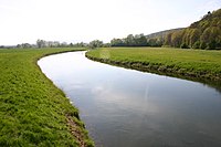
When you enter the Leinegraben , the middle course begins. The elevations on both sides of the broad geological rift valley running from south to north are collectively referred to as the Leinebergland . Most of the town centers in the Leinegraben are not directly on the river. It first passes Friedland , known for the Friedland transit camp set up near the intersection of three occupation zones . At Rosdorf the Rase flows from the left and from the right, the first tributary of over 20 km in length is the garden from the same area . In Göttingen , the first major city on the Leine, the river divides into the Leine Canal , which flows through the old town, and the main stream in a wide flood trough. Immediately to the east of the Göttingen core city, the Göttingen Forest rises as the border to the Rhume basin . At the Weende district , a Lutter flows from the east and the Grone from the west .


.jpg)
Then the line touches the western outskirts of Bovenden and Nörten-Hardenberg ; there the Harste and Espolde flow from the west and the Rode and Beverbach from the east . At Northeim at the northern end of the Wieter ridge , the Rhume flows from the south-east and carries more water than the Leine. To the west of the Northeimer Seenplatte the river debris brought in by the Rhume is intercepted. The Ahlsburg ridge rises a little to the west of the lake district . The adjoining very wide flood plain is diked as the Salzderhelden flood retention basin in order to protect the villages below from flooding.
Between Einbeck and Salzderhelden the river leaves the wide Leinegraben and takes in the Ilme at Volksen . The Leine passes the Hube ridge to the east and then reaches the Kreiensen railway junction . Shortly before Kreiensen the floodplain coming from the southeast flows , at Greene the Gande flows from the east . A narrow section of the valley follows between the Helleberg mountain ranges in the east and Selter in the west. The Leine runs further north through Freden and Alfeld , with the valley bordered by Sackwald and the Seven Mountains to the east and by Külf and Duinger Berg to the west. Below Gronau the Despe flows in from the east , further north near Elze the Saale flows in from the southwest .
Lower course
From about Nordstemmen , which it passes about 1 km to the west, the Leine enters the North German Plain between Hildesheimer Wald in the east and Osterwald in the west . At Nordstemmen you flow below the Marienberg with the Marienburg Castle from the west to the Haller . A few kilometers further north, the Leine flows past Sarstedt about 2 km west , then the Innerste flows from the south-east into Ruthe .
The mouth of the innermost is the zero point of the line's kilometers . The river kilometers are counted up and down from here. The state border between Thuringia and Lower Saxony is about 143 km above and the confluence of the Leine in the Aller at 112 km below.
In the further course the Leine passes Laatzen in the east and Hemmingen in the west. It then flows through Hanover , by far the largest city on its banks. In the city, it first flows along the edge of the Wülfel and Döhren districts and then past the Maschsee to the west . Here, most of its water is led over the Schnellen Graben to the small Ihme , which is wider than the river itself on the last few kilometers to the confluence with the Leine. The Maschpark , the old town, the Leineschloss with the Lower Saxony State Parliament and the Calenberger Neustadt . The Leinewasser , which is branched off to the Ihme, flows in again south of the Herrenhausen Gardens . About one kilometer further down the river - between Linden-Nord and Limmer - the Leine flows from the south to its feet . In the Limmer district , the connecting canal to the Leine flows into the river from the west , via which there are connections to the Hanover-Linden canal and on to the Lindener Hafen or the Mittelland Canal . The line is dammed up at this point by the Herrenhausen weir, which was equipped with a turbine to generate electricity and a fish ladder as part of an Expo project . Next to it is a historic lock to the Ernst-August Canal .
Expanded like a canal near Nordstemmen
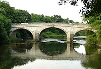
Leine bridge from 1751 in Schulenburg

The Innerste flows into the Leine near Sarstedt-Ruthe

At Basse ( Neustadt am Rübenberge )


.JPG)
_IMG_5932.jpg)
A section of the run directed to the northwest begins below Hanover. Here the line runs through a river loop around Letter to the north and another around Marienwerder to the south . This second loop touches the Hinüberschen Garten , the Leineaue of Marienwerder and at the end of the Seelze Bürgerpark . Between Seelze in the south and Garbsen in the north, it is crossed by the Mittelland Canal, which runs west-east, between Seelze and Seelze- Lohnde . The Westaue flows from the southwest at Bordenau . From now on, the Leine meanders strongly towards the north, including through the core town of Neustadt am Rübenberge , where it flows roughly parallel to the eastern border of the Steinhuder Meer nature reserve . In Neustadt a mill canal branches off , on which a small waterfall (with rapids when the water level is low) can be bypassed in the line; the canal supplied the mill in Neustadt.
muzzle
After that, the Leine runs a little north-east and finally back to the north, flowing a little north of Bothmer , a northern district of Schwarmstedt , and east of Gilten into the Aller , which comes from there from the east .
Catchment area and tributaries
The catchment area of the Leine is 6517.35 km². Their tributaries include - viewed downstream (if not otherwise stated, according to the individual records listed in the table header):
| Surname | page | Length (km) |
Source | Muzzle | Estuarine ort ( o / b / i / u ) |
EZG (km²) |
GKZ |
|
|---|---|---|---|---|---|---|---|---|
| height ( m above sea level ) | ||||||||
| Line | right | 6 km | 400 m | 325 m | Leinefelde (i) | 488-? | ||
| Etzelsbach | right | 4.7 km | 347 m | 287.0 m | Wingerode (i) | 488-? | ||
| Steinbach | right | 3 km | 325 m | 272 m | Soil digger (i) | 488-? | ||
| Geislede | Left | 13.5 km | 363 m | 250 m | Heilbad Heiligenstadt (i) | 50.5 km² | 488-12 | |
| Beber | right | 12.5 km | 341 m | 232.7 m | Heilbad Heiligenstadt (u) | 31.79 km² | 488-132 | |
| Lutter | Left | 7.5 km | 400 m | 230 m | Uder (b) | 488-? | ||
| Schleierbach | Left | 6.2 km | 308 m | 189 m | Niedergandern (b) | 15.49 km² | 488-1372 | |
| Molle | Left | 7.1 km | 300 m | 181 m | Friedland (o) | 8.94 km² | 488-1392 | |
| Wendebach | right | 16.2 km | 339 m | 162 m | Niedernjesa (o) | 36 km² | 488-814 | |
| Dramme | Left | 14.3 km | 370 m | 161 m | Obernjesa (u) | 53.41 km² | 488-152 | |
| Garden | right | 23.9 km | 300 m | 153 m | Rosdorf (b) | 88.89 km² | 488-16 | |
| Rush | Left | 4.4 km | 180 m | 152 m | Rosdorf (b) | 27.33 km² | 488-172 | |
| Lutter | right | 7.8 km | 342 m | 143 m | Turn (b) | 38.27 km² | 488-174 | |
| Grone | Left | 5.7 km | 159 m | 141 m | Holtensen (b) | 25.99 km² | 488-1752 | |
| Harste | Left | 9.1 km | 192 m | 130 m | Parents (b) | 55.63 km² | 488-176 | |
| Turn | right | 9.4 km | 170 m | 128 m | Angerstein (u) | 20.53 km² | 488-178 | |
| Rodebach | right | 10.2 km | 339 m | 128 m | Marienstein (b) | 18.14 km² | 488-1792 | |
| Espolde | Left | 16.1 km | 312 m | 126 m | Lütgenrode (o) | 67.83 km² | 488-18 | |
| Beverbach | right | 16.3 km | 252 m | 125 m | Nörten-Hardenberg (u) | 37.46 km² | 488-192 | |
| Moors | Left | 9.9 km | 205 m | 116 m | Höckelheim (b) | 43.33 km² | 488-194 | |
| Rhume | right | 42 km | 160 m | 111 m | Northeim (u) | 1186.93 km² | 488-2 | |
| Bells | Left | 13.6 km | 321 m | 108 m | Hollenstedt (u) | 20.29 km² | 488-32 | |
| Ilme | Left | 33 km | 340 m | 104 m | Volksen (o) | 393.04 km² | 488-4 | |
| Aue | right | 22.6 km | 285 m | 102.5 m | Haieshausen (b) | 113.12 km² | 488-512 | |
| Gande | right | 19.1 km | 241 m | 102 m | Kreiensen (b) | 113.37 km² | 488-52 | |
| Wisp | Left | 12.2 km | 260 m | 92.5 m | Wispenstein (b) | 72.74 km² | 488-54 | |
| Warnebach (Warne) | right | 5.5 km | 167 m | 89 m | Alfeld (b) | 488-? | ||
| Glene | Left | 9.3 km | 203 m | 85 m | Stretching (o) | 40.4 km² | 488-554 | |
| Despe | right | 10.9 km | 169 m | 76 m | Gronau (u) | 37.96 km² | 488-558 | |
| Saale | Left | 30.1 km | 254 m | 71 m | Elze (b) | 201.46 km² | 488-856 | |
| Haller | Left | 17.1 km | 127 m | 69 m | Marienburg Castle (o) | 123.88 km² | 488-58 | |
| Rössingbach | right | 13.3 km | 197 m | 62 m | Barnten (u) | 44.9 km² | 488-594 | |
| Gestorfer Beeke | Left | 5.3 km | 98 m | 61 m | Yes and no (u) | 12.82 km² | 488-596 | |
| Innermost | right | 100.7 km | 605 m | 58 m | Ruthe (u) | 1265.36 km² | 488-6 | |
| Kalsaune | right | approx. 100 m | m | Grasdorf (b) | ||||
| Me | Left | 26.2 km | 334 m | 48 m | Hanover (i) | 111.11 km² | 488-76 | |
| Feet | Left | 7 km | 61 m | 48 m | Hanover (i) | 20 km² | 488-772 | |
| Wages brook | Left | 7.3 km | 56 m | 42 m | Wages (b) | 13.11 km² | 488-794 | |
| Westaue | Left | 30.1 km | 52 m | 38 m | Liethe (u) | 594.73 km² | 488-8 | |
| Dead moor | Left | 11.4 km | 41 m | 32 m | Empede (o) | 49.46 km² | 488-912 | |
| Auter | right | 22.3 km | 47 m | 29 m | Averhoy (u) | 129.4 km² | 488-92 | |
| Jürsenbach (Jürse) | right | 10.3 km | 79 m | 28 m | Luttmersen (u) | 33.49 km² | 488-932 | |
| Great Beeke | right | 16.7 km | 43 m | 28 m | Vesbeck (u) | 52.82 km² | 488-94 | |
| Grindau | right | 10.8 km | 35 m | 27 m | Grindau (o) | 35.1 km² | 488-96 | |
| Abbreviations: o = above, b = at, i = im, u = below the muzzle | ||||||||
geology
A salt dome of the Zechstein at a depth of 200 m to 900 m below sea level called the Leinetal axis extends from the Adenser Berg over Wülfingen , Sorsum, Mehle, Saale-Mühle, Sehlde, Eime , Banteln and from then under the Leine to Freden and in a foothill to Sülbeck . The leaching of the salt dome in this axis of the Leine valley created a depression through which the Leine in the Quaternary after the Elster Cold Age , especially in the early Drenthe stage of the Saale Cold Age, from Freden via Banteln, Eime, Sehlde, Saale-Mühle, Mehle, Sorsum and Wülfingen in the Hallertal flowed. This former course of the river Leine can be identified in several places by the middle terrace gravel left behind by the river. In the broad northern valley of the Leine east of Elze , a lake formed during the Holstein warm period . There, the line created a breakthrough valley between the Teufelsberg and the Großer Rammelsberg , in which it runs today.
history
Primeval times
Up until the Elster Cold Age , the Weser flowed into the Leine between Adensen and Wülfingen from the Hallertal over a period of one and a half million years . The former common course of the Leine and Weser can be reconstructed through the Weserkies sites. On the former course of the river lie the following places: Nordstemmen , Rössing , Barnten , Sarstedt , Gleidingen , Rethen , Laatzen , Höver , Altwarmbüchen , Burgwedel , Mellendorf , Brelingen . Outcrops can be found, for example, at the gravel and sand pit northeast of Brelingen. Weserkiese can be followed via Hagen bei Neustadt in the direction of Nienburg / Weser . The oldest human stays in this area can be traced back to the Middle Paleolithic using the hand ax of poisons , discovered south of Sarstedt . Neanderthals and even Homo erectus could be detected in the Sarstedt area on the basis of skull remains in a Schliekum gravel pit.
Middle Ages and Modern Times

The first mentions concern the Leinegau : 954 Laginga, 997 Lainegha and 1029 pagus Lagina. Logging on the Leine has been documented since 1592 , initially from the Harz region to the east of the Leine, and from 1680 after completion of the Lakenteich also from Solling to the west of the Leine .
In 1734, scientists from Göttingen sent an expedition to explore the Leine springs, the strength and cleanliness of which the traders owed their town to prosperity and health. The results of the inspection were published and stated that the Leine rises in a headwaters of ten springs within the then village area of Alt-Leinefelde.
In the 19th century a branch canal connected the port of the Sülbeck salt works with the Leine. In the 20th century, the course of the Leine, like that of many other rivers, was straightened in order to protect the neighboring towns and communities from flooding, but this was not achieved until the 1970s with the construction of the Salzderhelden retention basin . Between Wispenstein , Föhrste and Banteln, several oxbow branches of the Leine have remained uneven.
In the course of the construction of the high-speed railway line Hanover – Würzburg , the line was laid over a length of 3.8 km. The aim was to avoid high dams and complex river and flood bridges, which would have become necessary if the railway line and river had crossed several times. Originally, the river was to be crossed twice with two bridges and three flood bridges. In addition, an eight meter high dam was to be built. The district of Northeim , the Flecken Nörten-Hardenberg and the Bundesbahn finally agreed to relocate the 3.8 km long line in a new river bed west of the new line and to relocate an affected district road as well. The new line could thus be led on a dam that is only four meters high. With the new waterway, a 40 to 80 m wide flood basin was created so that high water can flow away.
For several years now, several fishing clubs (including Alfeld, Gronau / Leine (salmon station), Einbeck, Bad Gandersheim / Kreiensen and Northeim) have been running a program upstream from Hanover to reintroduce the formerly native salmon . Thousands of young salmon are released every year, which are supposed to return after a few years when they are sexually mature in order to ensure that they are permanently on the line. In autumn 2004 the efforts were crowned with success. An 80 cm specimen of a previously released and marked salmon was found at the control station of the hydropower plant in Hannover-Herrenhausen . The Milchner was on the way to spawn in the Schnellen Graben , an artificial connection channel in Hanover between Leine and Ihme, in which he was released in April 2001. A fish ladder was built in Herrenhausen . The salmon project is an example of the improving water quality of the leash, another indication was the appearance of the allis shad in the summer of 2004 , which up to this point was considered extinct in Lower Saxony.
etymology
The name of the line changed several times over the course of time from Lagina in the tenth century to Loine, Leyne, Leina, Legine, Lagena, Lagina, Laigine, Lieinne and Leine. The Leine is pronounced in dialect , especially in the East Westphalian language area such as Laane .
Flora and fauna
Fish fauna
There are 32 species of fish in the Leine with its oxbow lakes near Hanover , including mainly carp , tench , chub , barbel , grass carp , roach , rudd and other species of white fish. The predatory fish are dominated by pike , pikeperch , perch , eel , brown trout and rainbow trout .
Shore fauna
There are numerous meadows along the banks of the Leine, including the Salzderhelden valley , where duck birds are part of the typical fauna. Some river meadows are occasionally grazed by the linen sheep named after the river . Since 2009 a return of beavers has been observed in the bank areas of the southern Leineaue near Hanover .
Shore flora

The flora in the protected areas includes the plants that are typical of alluvial forests , wet meadows and tall herbaceous vegetation . In the settlements as well as on the bridges and sewage treatment plants, vegetation is often sparse or absent, as some of the buildings extend right up to the water. The rest of the bank is also largely shaped like a cultural landscape and consists of species-poor grassland, so that the potential natural vegetation can only prevail over a fraction of the total length of the river .
Protected areas
At several points along the Leine, extensive landscape protection areas are marked out right up to the shore. In the district of Northeim, an area of approx. 6 km in length is under nature protection , which consists of the Polder I in the retention basin Salzderhelden, the Linen Niederung Salzderhelden and the Northeimer Seenplatte . In the Hildesheim district , the Leineaue under the Rammelsberg is an approximately 3 km long section of the river in the nature reserve. The nature protection areas of Leineaue between Ruthe and Koldingen and Alte Leine with a total length of around 7 km are largely located in the Hanover region . There are also three smaller nature reserves on the lower reaches of the Leine: the Sundern , the Wadebruch and the Helstorfer Altwasser . Some areas near the Leine, such as Alfeld, are classified as water protection areas.
use
Drinking water is not obtained from the leash, since the adjacent waterworks prefer groundwater and reservoir water.
tourism
The source area of the Leine has been declared an area monument. A long-distance cycle route Leine-Heide-Radweg was established from the sources to the mouth . This also has a connection to the Werratal cycle path near Witzenhausen or the Weser cycle path near Hann. Münden as well as to the Europaradweg R1 at Einbeck and again to the Weserradweg at Hoya . Cities worth seeing along or near the Leine are Heilbad Heiligenstadt , Göttingen , Northeim , Einbeck , Alfeld , Hildesheim and Hanover . In the middle reaches of the Leine from Einbeck and in the lower reaches, several commercial providers offer canoe tours, which mainly take place in the warm season and especially in the city of Hanover.
shipping
The Leine is navigable from Hanover (weir in the Schnellen Graben km 16.75) to its confluence with the Aller (km 112.08). It is a federal waterway , for which the Waterways and Shipping Office Braunschweig is responsible up to km 68.00 down and from there to the mouth of the Waterways and Shipping Office Verden . From kilometers 20.50 to 22.78 (Herrenhausen weir) waterway class IV applies with restrictions, from kilometer 110.00 to the confluence with Aller class II. However, there is no longer any continuous ship traffic. The Leine is only used locally with very small motor boats. Above the Leine weir in Hanover-Herrenhausen, the Leine and the Ihme estuary are used by passenger ships and sport boats. On the west side of the Maschsee , the Schnelle Graben connects the Leine with the Ihme. At the Schnellen Graben a weir was put into operation in 1745 to relieve the Leine during floods and to divert the water through the Ihme around Hanover. After the weir has been renewed, a certain amount of water is always diverted into the artificial rapid ditch via the hydroelectric power station that has existed there since 1922. The weir system is operated as required to regulate the water level on the line. From here the (Ihme) line is navigable. The Leine mainly runs through protected landscape areas; therefore it is forbidden to drive continuously on the Leine from Hanover to Aller with motorboats.
This area is connected to the Mittelland Canal via the connecting canal to the Leine and the Hannover-Linden branch canal . Before the Leine joins the Aller, the lock canal of the Allerschleuse Hademstorf joins the Leine, in this area the Allerschifffahrt runs through the Leine over a length of 1.54 km.
In the course of the federal waterway there are two barrages that are equipped with locks. The lock in Hanover-Herrenhausen, built in 1720, is out of order. It had completely crumbled and silted up by floods. In the years 1997 to 2000 it was restored true to the original. However, it is not possible to use it because the underwater Ernst August Canal , which connects the underwater lock to the Leine, is no longer navigable. The listed lock in Neustadt am Rübenberge, from 1736, has been closed since 2006 by the Waterways and Shipping Authority. It was occasionally used as a self-service lock by rowers.
Line power plants
- The Erzhausen pumped storage power plant , the only one of its kind in Lower Saxony, is located near Kreiensen . It has a nominal output of 220 MW.
- In Hanover , the Leine's hydropower is used in two run-of-river power plants with a nominal output of 630 kW and 940 kW respectively to generate electricity .
Cooling and service water
- The Linden thermal power station is formally located on the Ihme , but in this section it mainly carries Leine water.
- The Sappi paper mill in Alfeld uses linen water as process water.
literature
- Günter Gebhardt: Military affairs, economy and traffic in the middle of the Electorate and Kingdom of Hanover 1692–1866 . Studies on the history of Lower Saxony, vol. 1, ibidem (Edition Noëma), Stuttgart 2010. ISBN 978-3-8382-0184-9
- Gerd Lüttig: New results of quaternary geological research in the Alfeld-Hameln-Elze area. In: Geological Yearbook Volume 7, Pages 337-390. Hanover, June 1960
- Uwe Schmida: The Leine - A Photographic Journey . Self-published illustrated book, 2007. ISBN 978-3-00-020567-5
- Martin Eckoldt (Ed.): Rivers and canals. The history of the German waterways. DSV-Verlag Busse Seewald, Hamburg 1998, ISBN 3-88412-243-6 .
Web links
- Landscape profiles of the Federal Agency for Nature Conservation (BfN), on bfn.de:
- Leineverband (official homepage)
References and comments
- ↑ a b DTK 25 http://www.geoproxy.geoportal-th.de/geoclient/control
- ↑ a b c d Lengths (in km) of the main shipping lanes (main routes and certain secondary routes) of the federal inland waterways ( memento of the original from January 21, 2016 in the Internet Archive ) Info: The archive link was inserted automatically and has not yet been checked. Please check the original and archive link according to the instructions and then remove this notice. , Federal Waterways and Shipping Administration
- ↑ a b Final measurement using a drawn GPS track from the upper end point of the HWRM stationing of the NLWKN, see Lower Saxony environmental maps : Leine at the transition from Thuringia to Lower Saxony
- ↑ a b c d e f g Environment map service of the Lower Saxony Ministry for the Environment, Energy and Climate Protection ( information )
- ^ Deutsches Gewässerkundliches Jahrbuch Weser-Ems 2014. Lower Saxony State Agency for Water Management, Coastal Protection and Nature Conservation, p. 192, accessed on October 4, 2017 (PDF, German, 8805 kB).
- ^ Waldemar R. Röhrbein: Leine. In: Klaus Mlynek, Waldemar R. Röhrbein (eds.) U. a .: City Lexicon Hanover . From the beginning to the present. Schlütersche, Hannover 2009, ISBN 978-3-89993-662-9 , p. 395f.
- ↑ Weir Herrenhausen , on wsa-braunschweig.wsv.de
- ↑ The Leine weir , the shallows, the shipping on the Leineschifffahrt, waterfall, ... in Neustadt , on ruebenberge.de
- ↑ For a better overview and sorting downstream, a hyphen has been inserted for each river in the water code number (GKZ) after the number "488", which stands for the line .
- ↑ a b c d Length information per function drawing and measuring in the environmental map service of the Lower Saxony Ministry for the Environment, Energy and Climate Protection ( notes )
- ↑ Table 01 Description of the waters ; see below in C-Report 18 Leine / Ilme → Tables (Water Framework Guidelines-InfoBörse (WIB); Kommunale Umwelt-AktioN UAN), accessed on May 13, 2016, on wrrl-kommunal.de
- ^ Thuringian State Institute for the Environment (ed.): Area and waterway key figures (directory and map). Jena 1998. 26 pp.
- ↑ Adolf Hoffmann: Explanations of the Geological Map of Prussia and neighboring German countries , Delivery 265, sheet Elze , No. 2089. Geological State Institute Berlin 1927, pp. 7-10.
- ↑ Geological hiking map of the district of Hanover , 1: 100,000, Hanover 1977 and Geological hiking map of Leinebergland , 1: 100,000, Hanover, 2nd edition, 1989.
- ↑ Gerd Lüttig: New results of quaternary geological research in the Alfeld-Hameln-Elze area. In: Geological Yearbook Volume 77, Pages 337-390. Hanover, June 1960. See pp. 378-382.
-
↑ Literature:
- Ludger Feldmann and Klaus-Dieter Meyer (eds.): Quaternary in Lower Saxony. Excursion guide to the anniversary general meeting of the German Quaternary Association in Hanover. DEUQUA excursion guide, Hanover 1998, p. 89ff.
- Hans Heinrich Seedorf and Hans-Heinrich Meyer: Lower Saxony regional studies. Nature and cultural history of a federal state. Volume 1: Historical basics and natural features. Wachtholz, Neumünster 1992, p. 105ff.
- Ludger Feldmann: The Quaternary between Harz and Allertal with a contribution to the history of the landscape in the Tertiary. Papierflieger, Clausthal-Zellerfeld 2002, p. 133ff. and passim .
- Manfred Boetzkes, Ingeborg Schweitzer, Jürgen Vespermann (eds.): EisZeit. The great adventure of mastering nature. Book accompanying the exhibition of the same name. Jan Thorbecke Verlag, Stuttgart 1999 and Roemer- und Pelizaeus-Museum Hildesheim 1999, p. 95ff. and passim. - ↑ Gravel and sand pits (PDF; 219 kB)
- ^ Ernst Förstemann: Altdeutsches Namenbuch, Vol. 2: Place names. Nordhausen 1859. p. 889.
- ^ Heinrich Daniel Andreas Sonne: Earth Description of the Kingdom of Hanover , 1817, p. 28
- ^ A b Deutsche Bundesbahn, project group Hanover – Würzburg North of the Federal Railway Directorate Hanover: New Hanover – Würzburg line. The Edesheim – Göttingen section . Brochure (28 pages) dated September 1983, pp. 6, 11.
- ^ Leine , Fischereiverein Hannover e. V.
- ↑ NABU: The beaver is back at the gates of the state capital Hanover! ( Page no longer available , search in web archives ) Info: The link was automatically marked as defective. Please check the link according to the instructions and then remove this notice.
- ↑ Directory E, Ser. No. 28 and directory F of the Chronicle ( Memento of the original from July 22, 2016 in the Internet Archive ) Info: The archive link was inserted automatically and has not yet been checked. Please check the original and archive link according to the instructions and then remove this notice. , Federal Waterways and Shipping Administration
- ^ Information from the Braunschweig Waterways and Shipping Office from August 28, 2012