
Salzderhelden flood retention basin
| Salzderhelden flood retention basin | |||||||||||
|---|---|---|---|---|---|---|---|---|---|---|---|
 |
|||||||||||
|
|||||||||||
|
|||||||||||
| Coordinates | 51 ° 47 '51 " N , 9 ° 55' 6" E | ||||||||||
| Data on the structure | |||||||||||
| Construction time: | 1972-1994 | ||||||||||
| Crown length: | 116 m | ||||||||||
| Data on the reservoir | |||||||||||
| Storage space | 1.07 million m³ | ||||||||||
| Total storage space : | 37.4 million m³ | ||||||||||
| Catchment area | 2200 km² | ||||||||||

The Salzderhelden flood retention basin , also known as Leinepolder Salzderhelden , is a dam on the Leine in Salzderhelden , Northeim district , Lower Saxony . It serves the flood protection of the Leinetal in southern Lower Saxony .
description
The flood retention basin covers a good third of the Leine's catchment area . The total storage volume is almost 40 million cubic meters on an area of around 1,000 hectares. It is operated by the Lower Saxony State Office for Water Management, Coastal Protection and Nature Conservation . In addition, it is of international ecological importance for bird protection.
Location and function
The location in the Leinetal between Salzderhelden and Northeim was deliberately chosen: of the total precipitation catchment area of the Leine of 6,500 square kilometers between the source and the mouth, the retention basin with 2,200 square kilometers affects a good third. This also includes the southern Harz with its foreland , which is rich in precipitation . As a result, the flood retention basin has a major impact on the course of the floods in the downstream areas of the Leinetal, including the cities of Alfeld and Hanover .
A computer-aided control and flood forecast model reflects the actual precipitation and runoff events in the entire Leine catchment area between the source and Hannover-Herrenhausen. It provides precise forecasts about the expected course of a flood event.
The flood retention basin has a total storage volume of 37.4 million cubic meters on an area of around 1,000 hectares, which is divided into five polders . In the event of a flood, polder 1 with a capacity of 16 million cubic meters is dammed first, then the water flows into polders 2, 3 and 4. Special staggered overflow sections are used for this. Polder 5 is only used in extreme cases.
construction
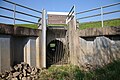
Construction of the flood retention basin began in September 1972. Official commissioning was in March 1994 after a successful full test stowage. A total of around 30 km of dams were built, 2 million cubic meters of soil were moved, and pumping stations and bridges were built. Central is the final structure with a length of 116 meters in Salzderhelden near Einbeck . It comprises five segments. The middle three have segment weirs 15 meters in length. All five segments are equipped with fish belly flaps to relieve the flood.
Since 2000, operations have been optimized by a process control system in the control center and a computer-aided control and flood forecast model.
natural reserve
In addition to flood protection, the flood retention basin has achieved international ecological importance: In part of the area, a renatured habitat has been created for numerous endangered native birds and migratory birds such as storks , kingfisher , gray goose , heron and cormorant .
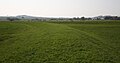
The area of Polder I with a specially created permanent lake is under nature protection . With 523 hectares, it is the largest nature reserve in the Northeim district . The remaining polders are used for agriculture to different degrees.
Picture gallery

Nature reserve in the retention basin polder, September 2009

Flood situation, May 2013
Overflow connection between two polders, April 2011
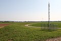
Polder dams (towards Hollenstedt)
Polder dams (towards Stöckheim / Drüber)


See also
Web links
- Description from the Lower Saxony State Office for Water Management, Coastal Protection and Nature Conservation
- Leash bandage