Salzder heroes
|
Salzder heroes
City of Einbeck
|
||
|---|---|---|
| Coordinates: 51 ° 47 ′ 50 " N , 9 ° 54 ′ 45" E | ||
| Height : | 110 m above sea level NN | |
| Area : | 9.98 km² | |
| Residents : | 1823 (Jan. 2019) | |
| Population density : | 183 inhabitants / km² | |
| Incorporation : | March 1, 1974 | |
| Postal code : | 37574 | |
| Area code : | 05561 | |
|
Location of Salzderhelden in Lower Saxony |
||
|
View from the Heldenburg to the east on parts of Salzderhelden
|
||
Salzderhelden has been one of the 46 districts of Einbeck and a patch since 1974 . The name probably goes back to the medieval “Salz an der Halde”, but it may be a combination of “ Salt ” and “ Hall ”. Salzderhelden was of great importance due to the salt production in the salt works and was the seat of the ducal, mint and political center.
geography
Salzderhelden is located in southern Lower Saxony in the Leinebergland , about 35 km north of Göttingen and four kilometers south-east of Einbeck. The line flows through the place before it picks up the Ilme .
history
The place lies in the flood area of the Leine and has been drained by Flemish immigrants. The neighboring settlements of Oldendorp , Jeinsen and Bönickenhusen, some of which had existed since 800, were later abandoned and the residents moved to Salzderhelden.
At the request of the Pfänner, a Marienkapelle was built in the new place in 1271 . In 1285 Salzderhelden was mentioned in the country settlement between the three sons of Duke Albrecht. The knight Johann Rieme died in Salzderhelden in 1289 and is buried in Wiebrechtshausen .
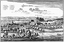
Duke Heinrich der Wunderliche came into possession of the Heldenburg in 1291 - where he died in 1322. With him began the supra-regional importance of the place as a ducal seat, mint and political center. In 1305, a large knight tournament was held in accordance with the increased importance. The place began to grow and the main church was moved to Salzderhelden in 1333. In 1361, when Albrecht I of Braunschweig-Grubenhagen took office in Salzderhelden, he first used the Sachsenross , which today adorns Lower Saxony's coat of arms.
In 1448 the place already had a fortification, so that an attack by the Hussites in the course of the Soest feud could be repulsed. In 1450 the place received another chapel below the castle, which is still preserved in the foundation walls. In 1480 the place was granted the right to place spots , in 1493 the main church got a bell tower. From this time on, the former Salzderhelden office has also been handed down. The spots Salzderhelden, Hollenstedt , Drüber , Sülbeck , Immensen , Negenborn and Volksen (Volxen) belonged to it. These villages were founded by Duke Ernst III. established from 1549 widowhood for his wife, Princess Margarethe von Pommern-Wolgast. In a document from 1494 the villages Buensen (Buwensen), Edemissen , Kuventhal (Kuvendalle), Rengershausen and Andershausen are also listed. After the abolition of the office, the villages formed the Vogtei Salzderhelden. The official building was cremated during the Thirty Years War and rebuilt in 1624 by Christian von Braunschweig-Wolfenbüttel . In 1523 the place burned down completely. In 1541 a separate council school and a new church order were mentioned for the first time.
In the years 1590 to 1594 the flood protection facilities were renewed. In 1600 the current castle tavern was built as an office building. In 1623 a new major fire incinerated the place, but the church, school and 35 houses were saved. The reconstruction proceeded quickly, in 1624 the Vorwerk near the mill was rebuilt. In 1625 and 1633 there was looting during the Thirty Years' War. The plague came to Salzderhelden, and in addition to the victims in the population, six children of the landlord von Minnigerode died . In 1637 the place was called the “little mountain town of Salt of Heroes”.
The population had decreased due to the war, the deterioration in brine production and the plague, but new citizens were taken in after the war. The house book of 1664 mentions 78 houses in the Flecken, including 33 pans, 17 salt drivers, six salt carriers, five smiths, three brandy distillers, three bakers and outside the village of Büter in another ten smaller houses. The residents of the Vorwerk with brewery, mill and barns were not counted. around 1680 the town hall could be rebuilt. Later, the residents, also known as Pfänner, leased their salt wells to the government in order to introduce innovations and obtain financial security. The competition with the sovereign salt works in Sülbeck had become stronger and stronger.
In 1740 a flood of the century brought great destruction. In 1764 the Amtshof was built and the construction of the new church began. The paved Hannoversche Chaussee was built in 1774 and brought further economic upturn. The linen plant was moved to Salzderhelden and a factory for woolen fabrics was established. However, the business was unsuccessful, so the indebted property worth 30,000 thalers was bought in 1850 and distributed to 83 residents.
The station was inaugurated on August 1, 1854. In 1912 there were 214 houses with 350 workers, including 52 builders, 48 potash miners, 33 craftsmen, 30 railway workers and 26 salt workers. In 1926 a new schoolhouse was built, and in 1935 a river bathing establishment was also built. After the Second World War , many expellees from Silesia , East Prussia , the Zhitomir region and the Baltic came to Salzderhelden, so that the population rose from 1,000 to 1,800. In 1951 an open-air stage was built on the castle ruins.
On March 1, 1974, the patch Salzderhelden was incorporated into the city of Einbeck.
politics
Dirk Heitmüller of the SPD has been the local mayor since November 2011. After the last local election in September 2016, the local council was composed as follows:
coat of arms
Blazon : "In red a golden salt pan from which blue-silver steam clouds rise and an outwardly inclined black salt jar rises on both sides." For the first time in 1451, the council asked the Duchy of Braunschweig-Lüneburg to be allowed to wear its own seal . This was later used by the council together with the pans of the unionized saltworks at Salzderhelden. The coat of arms of today is based on a picture with pan devices in the signet from around 1820, while the colors are more recent. In the stain seal, however, the coat of arms appears without a shield.
Culture and sights

Buildings
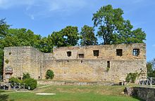
- Castle ruins of the Heldenburg with Palaswand and castle museum in the cellar
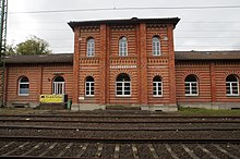
- Station building with home parlor built according to plans by Conrad Wilhelm Hase
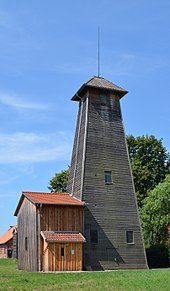
- Saline Salzderhelden (winding tower, brine tank, bathroom)
- the St. Jacobi Church, built in 1769, with its baroque altar
- Johanneskapelle, built from 1450 on a horse leash; only outer walls preserved
- former town hall / rectory from the 19th century
- Office building from 1600, now Burgschänke
- Official court from 1764 with royal coat of arms
- Construction of the war grave cemetery in 1951
- The flood retention basin of the Leine is of supra-local importance.
societies
- German Red Cross Local Association Salzderhelden
- Friends of Heldenburg Salzderhelden e. V.
- Mixed choir Salzderhelden
- Kultur-Förderkreis-Salzderhelden e. V.
- MGV Concordia men's choir
- Schützenverein Salzderhelden from 1959 e. V.
- VfR Salzderhelden
- VCP Salzderhelden / Pathfinder
- Voices choir
- Local social association Salzderhelden
- Friends of the elementary school in Salzderhelden Vogelbeck
- Salzderhelden volunteer fire brigade
- Parish
- kindergarten
Lettering on the slope
Salzderhelden is also known by name for a geoglyph on the eastern slope of the Kleiner Heldenberg north of the village ( ⊙ ), which represents the place name and is clearly visible to traffic on the B 3 in the direction of Einbeck and from the railway lines. The approximately 100 meter long lettering made up of letters up to 13 meters high is made of poured limestone. It was laid out in 1932 by master bricklayer Karl Schrader and over 100 helpers and has been regularly cleared of dirt and vegetation by residents since then.
Economy and Infrastructure
In the 1970s, a wellness center was planned as part of the polder construction, but like the “Freizeitsee Einbecker See” project, it was not implemented. A kindergarten, the sports hall, the youth center and the house of sports were built in this decade.
traffic
train
Salzderhelden station is located on the Hanover Southern Railway and is connected to Göttingen, Kreiensen and Hanover approximately every hour . The Ilmebahn , the railway line from Salzderhelden to Einbeck, was closed to passenger traffic in 1984 and since then has been served exclusively by bus route 230 within the framework of the Verkehrsverbund Süd-Niedersachsen ( VSN ). The route has been reactivated since 2016 and put back into operation when Deutsche Bahn's timetable changed on December 9, 2018.
Street
Salzderhelden is on the B 3 and the Leine-Heide cycle path . The next motorway junction is the Northeim-Nord junction of the A 7 8.3 km south.
Web links
Individual evidence
- ^ Leaflet with numbers about the city of Einbeck . Retrieved December 24, 2019.
- ↑ Rudolf Eckart: History of the patch and the castle Salzderhelden . In: History of South Hanoverian castles and monasteries . tape 6 . Bernhard Franke, Leipzig 1895, p. 4 .
- ↑ Georg Schambach: Dictionary of the Low German Dialect of the Principalities of Göttingen and Grubenhagen , 1898, p. 36
- ^ Federal Statistical Office (ed.): Historical municipality directory for the Federal Republic of Germany. Name, border and key number changes in municipalities, counties and administrative districts from May 27, 1970 to December 31, 1982 . W. Kohlhammer GmbH, Stuttgart / Mainz 1983, ISBN 3-17-003263-1 , p. 207 .
- ↑ Klemens Stadler: German coat of arms Federal Republic of Germany . The municipal coats of arms of the federal states of Lower Saxony and Schleswig-Holstein. tape 5 . Angelsachsen-Verlag, Bremen 1970, p. 69 .
- ↑ Report of an intermediate cleaning on the website of the place , accessed on November 12, 2019
- ↑ http://ilmebahn.de ilmebahn.de, accessed on October 20, 2017


