Stroit
|
Stroit
City of Einbeck
|
||
|---|---|---|
| Coordinates: 51 ° 53 '23 " N , 9 ° 51' 38" E | ||
| Height : | 195 (195-230) m | |
| Residents : | 344 (Jan. 1, 2017) | |
| Incorporation : | March 1, 1974 | |
| Postal code : | 37574 | |
| Area code : | 05565 | |
|
Location of Stroit in Lower Saxony |
||
|
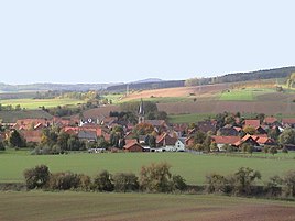
View from the windmill on Stroit
|
||
Stroit is a northern town in the town of Einbeck in the Northeim district , in southern Lower Saxony .
geography
Stroit is located in the Leinebergland between the mountain ranges of Selter in the northeast, Hube in the south-southeast and Hils in the west-northwest. The small village is located on the slope of the Hils mountain range at around 195 to 230 m above sea level. NN and is traversed by the Stroiter Bach.
history
The place was first mentioned in 1130 under the name Struth . From 1807 to 1813 Stroit was part of the canton of Greene . The village school was closed in 1971. The village belonged to the municipality Auf dem Berge in the district of Gandersheim until the administrative reform in 1974 .
On March 1, 1974, the Stroit community was incorporated into the city of Einbeck.
politics
Local council
The local mayor is Gerhard Mika (WG). The local representative is Ulf Meibohm. (As of February 2017)
The Einbeck towns of Bartshausen, Brunsen, Hallensen, Holtershausen, Naensen, Stroit, Voldagsen and Wenzen elect a joint local council. Today, as a village in Einbeck, it belongs to the local council "Auf dem Berge".
coat of arms
The Stroit coat of arms shows a silver Dutch windmill at the top and three green rushes with bulrushes at the bottom, in the shield, which is diagonally divided from blue to gold. There is a green mountain in the base of the shield. The Stroit windmill is a so-called Dutch windmill, where the cap can be turned. It is said to have been Dutch settlers who reclaimed the formerly swampy area in Stroit and south of the village. The rushes should remind of this original landscape. The mountain in the base of the shield is the common emblem of the villages "Auf dem Berge". The color blue-gold indicates that it belongs to the former Duchy of Braunschweig .
Culture and sights
church
The first church building is said to date from the 12th or 13th century and was probably once consecrated to John, as it is in the corridor of the "Johannisanger". The old church had a peculiarly sloping choir, was a massive building that was probably built in two periods. The masonry consisted of colored sandstone . The roof was covered with sandstone slabs from the Solling . Around 1619 the nave was fitted with a flat ceiling. In 1880 it was demolished because it was in disrepair.
In the spring of 1888 the construction of the church in Stroit began under the direction of the government master builder Sieburg. It was inaugurated in 1890. The new church, built in the neo-Gothic style popular at the time , is relatively large for the small town: approx. 30 m long, 12 m wide, the tower is 41 m high.
During the renovation carried out between 1964 and 1965, the interior was painted light and discreet, the wooden furnishings were left in their natural color.
A crucifix found in the church attic was restored on the recommendation of the regional church office and covered with gold leaf. This old crucifix now adorns the apse of the church and can - even if it is only classified as "a fairly craft-like, baroque work" - can be described as historically valuable.
In the course of the church renovation, a grave slab from around 1690 was also uncovered in the chancel. From the text it can be read that Stroit and Brunsen already had a pastor together back then. This sandstone slab was also restored and placed in the entrance area of the church.
In 1996 the church got two new bronze bells. The big bell bears the inscription: "Blessed are those who hear God's word and keep it". The organ dates from 2003.
War memorial
In front of the church there is a memorial for the local victims of the First World War and the Second World War .
Windmill
The Stroiter Mill is an important technical monument not far east of the village center.
Economy and Infrastructure
Companies
In addition to a few part-time farmers, there are only very few efficient full-time farms. At handicraft businesses you can find two tree nurseries, an earthworks company and a home slaughterhouse. Most of the villagers go to work in the surrounding larger towns. The schoolchildren are educated in the primary school in Wenzen and in the secondary schools in Einbeck.
traffic
Stroit is located between Ammensen , Brunsen and Naensen about 1.5 km west of the B 3 (section Alfeld - Einbeck ). The Altenbeken – Kreiensen railway line ( Stadtoldendorf –Kreiensen section ) runs south past the village , without a local stop.
Web links
Individual evidence
- ↑ [1] . Retrieved February 20, 2017.
- ^ Stroit. Local council "Auf dem Berge", 2015, accessed on April 13, 2017 .
- ^ Federal Statistical Office (ed.): Historical municipality directory for the Federal Republic of Germany. Name, border and key number changes in municipalities, counties and administrative districts from May 27, 1970 to December 31, 1982 . W. Kohlhammer GmbH, Stuttgart / Mainz 1983, ISBN 3-17-003263-1 , p. 207 .
- ↑ That Stroit there - his historical career
- ↑ Pictures from the Stroiter Church


