Weser sandstone
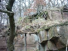
The term Weser sandstone refers to natural sandstone that occurs in the Solling sequence (uppermost Middle Buntsandstein ) in the Upper Weser and Lower Diemel (eastern Weser Uplands ) in southern Lower Saxony and northern Hesse.
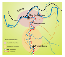
With the Weser sandstone in the narrower sense a distinction is made between the Karlshafen sandstone (Karlshafen layers) or red Weser sandstone , and the Trendelburg sandstone (Trendelburg layers) or gray Weser sandstone . In the area between Holzminden , Eschershausen , Stadtoldendorf and Bad Karlshafen , Weser sandstone in the broader sense (i.e. including Solling sandstone deposits that cannot be clearly divided into Karlshafen and Trendelburg layers) is being mined.
Emergence
The formation of the Weser sandstone dates back around 245 million years to the early Mesozoic , or more precisely: to the early Triassic . Extensive river systems brought in loose sands from the south , which were deposited in the area of today's Weserbergland in the so-called Reinhardswald-Trough , a sub-basin in the north of the Hessian Depression and thus a small sub-basin of the Germanic Basin . The climate in the Germanic Basin at that time was predominantly hot and relatively dry. Seasonal, heavy rainfall at least periodically supplied the region with water so that a species-poor flora and fauna could survive.
In the course of the following millions of years, various other sediments were deposited under diverse environmental conditions, which finally reached a total thickness of more than a thousand meters. The loose river sands of the early Triassic gradually solidified to form sandstone under the load of these surface layers . As a result of the uplift of large areas of Central Europe during the Tertiary and especially the uplift of the so-called Solling vault in today's southern Lower Saxony and northern Hesse, the surface layers were largely removed again and the Weser cut into the red sandstone layers between Solling and Reinhardswald with a middle one in the course of the last million years Rate of 20 centimeters per millennium.
Stratigraphic and spatial distribution
Weser sandstone is not a lithostratigraphic name, but the trade name of sandstones of the Solling sequence of northern Hesse and southern Lower Saxony, which are mined as natural stones.
The Solling sequence or Solling formation (lithostratigraphic abbreviation: smS) forms the uppermost part of the Middle Buntsandstein (sm) nationwide . The strata of the Solling Formation, which contain the Weser sandstones, are officially called Trendelburg strata (smS2, contain the gray Weser sandstone) and Karlshafen strata (smS3, contain the red Weser sandstone). This nomenclature is based on a regional breakdown of the Solling formation into a total of four sub-units:
- Originated layers (smS4),
- Karlshafen layers (smS3),
- Trendelburger layers (smS2) and
- Wilhelmshausen layers (smS1) (= Solling base sandstone)
Such a distinction can apparently only be made in the central part of the approximately north-south-trending Reinhardswald trough, which corresponds to a present-day distribution area in the Reinhardswald (northern Hesse) and southern Solling (southern Lower Saxony). Towards the edges of the basin (including in the north of Solling) only the Solling sandstone (smSS) is withstood. Outside the Reinhardswald trough, the Solling sequence is structured differently, in the Thuringian Basin, for example, into the Solling base sandstone (smSB), the Solling intermediate medium and the Thuringian chirotheria sandstone (smST). The total thickness of the Solling formation in the central part of the Reinhardswald trough is about 120 meters.
The Trendelburg strata mainly come to light in the Diemeltal, on the western edge of the Reinhardswald (northern Hesse). The Bad Karlshafen layers are predominantly to the right and left of the Weser, in southern Solling, widespread.
Properties and use
General
The Weser sandstones have well-rounded, fine to medium-sand quartz grains and are characterized by a relatively small pore volume. The quartz content is 85 to 99 percent. Their reddish color comes from the iron ore minerals limonite (brown iron) and hematite (red iron). They are relatively weatherproof.
Red Weser Sandstone (Karlshafen Sandstone)

Mica , a common component of clastic sedimentary rocks , occurs in the Weser sandstones of the Karlshafen strata to an extraordinarily high degree and is evenly stratified. This makes it easy to split the rock into plates up to one centimeter thick, which can be separated from one another with wedge iron and fists. The use of these sandstone slabs from the 17th century for roofing and in the form of curtain slabs as weather protection for shingling house facades is an absolute specialty and typical of the architectural style in the region. The laying of such roof and facade panels is still carried out today, mainly when re-roofing listed buildings. Thicker slabs, so-called laying or thinning stones , were used as flooring in houses, stables, churches and slaughterhouses.
Technical specifications:
- Bulk density 2.42 g / cm³
- Water absorption (atm.) 2.04% by weight
- Compressive strength 135 N / mm²
- Flexural strength 21.30 N / mm²
- Abrasion resistance 12.3 cm³ / 50 cm²
Fossils
In the red sandstone of the Weser , track plates were found showing the footprints of various reptiles that were native to the river landscape around 245 million years ago: predatory early archosaurs as well as early lepidosaurs and "higher" non-mammalian therapsids . The corresponding footprints are called Chirotherium sickleri , Rhynchosauroides bornemanni , R. schochardti and Dicynodontipus geinitzi and are exhibited in the Natural History Museum in Kassel and in the Geological-Paleontological Institute of the University of Göttingen .
Gray Weser sandstone (Trendelburg sandstone)
The gray Weser sandstone fluctuates in color between light gray, purple, yellowish and brownish, contains hardly any mica and is therefore far less gap-free than the red Weser sandstone. Mainly bricks , cobblestones , steps , cross and gravestones as well as pig troughs and figurative works of art were made from it. Most of the time, however, it was processed into rubble stones.
Fossils
Fossil finds in the gray Weser sandstone are mainly of a vegetable kind, predominantly horsetail ( Equisetites mougeoti ), the landmarks of which are well preserved. They presumably existed on the banks of the red sandstone rivers, possibly also stable sandbanks over a longer period of time, from which they were torn off and washed away when the channels were relocated, in order to finally be embedded in the sediment at another point of the river course.
Dismantling
Quarries in which specific stone qualities are mined in a targeted manner have only existed in the Weser sandstone area since the 19th century. Nevertheless, sandstones were used as a material for the construction of buildings such as the monastery in Helmarshausen or the Krukenburg as early as the High Middle Ages . They were dismantled in stone pits in the immediate vicinity of the building, regardless of the stone quality. The overburden that could not be used was moved to nearby Kummerhalden .
Only pits with high-quality stones became the starting point for later quarries, whose location close to the Weser and Diemel estuaries made it possible to load the hewn stones onto barges via chutes and to transport them up and down to the castle construction sites of the Weser Renaissance . Upstream of the Diemel, this was taken over by the Carlsbahn , the first railway in the Electorate of Hesse , from 1848 , and the Solling Railway along the Weser from 1873 . Quarries that could not use these transport routes were abandoned.
Over the past three centuries, countless abandoned pits and spoil heaps have emerged, some of which are now hidden under a thick cover of vegetation . In the Bad Karlshafen area there are still five producing Weser sandstone quarries above the Juliushöhe on the left of the Weser and above the Hanoverian cliffs on the right of the Weser. The red Weser sandstones , broken here with modern machines, are of high quality and are mainly used for restoration purposes. But also further north, Solling sandstone is broken and processed under the name “Roter Weser sandstone”. a. near Arholzen east of Holzminden .
Buildings

Weser sandstone has been used in masonry construction since at least the 11th century as quarry stone and ashlar (house stone), e.g. B. in the construction of the Kilianikirche in Höxter . The result is quarry stone masonry and ashlar masonry / ashlar masonry mostly as regular or irregular layered masonry. Since the 15th century, cleavable material has been split with wedges or by weathering (frost splitting) and used as split tiles (split stone) for the production of roof tiles and facade tiles (facade curtains).
Trendelburger sandstone
- Lippoldsberg monastery church
- World Heritage Site Corvey Castle in Höxter
- Hotel Menzhausen in Uslar
- Lion monument of Landgrave Karl von Hessen in Bad Karlshafen
Weser sandstone i. w. S.
- Arensburg bridge A 2 district Bückeburg (facing brickwork)
- Werra Valley Bridge Hedemünden (facing brickwork)
- Naval Memorial Laboe Open Space (pavement)
- Wasserschloss Hehlen (roof covering)
- Corvey Castle, Höxter (roof covering)
- Erlöserkirche Hannover (Altar)
- Kilianikirche Höxter (roof covering and masonry)
Karlshafen sandstone
- Historic port facility in Bad Karlshafen
See also
References and comments
- ↑ Note: "Hessian Senke" means an almost north-south-running sedimentation area in the Germanic Basin, which was bounded in the east by the Rhenish massif and in the west by the so-called Eichsfeld-Altmark-Schwelle, ie a paleogeographic structure. This old sedimentary basin should not be confused with what is regionally understood as the " Hessian Basin ", an area in southern Lower Saxony and eastern Hesse that is characterized by almost north-south trending faults and, as a predominant area of erosion in the Tertiary, less prominent was found as several adjacent clods (Rhenish Slate Mountains, Harz, Thuringian Forest)
- ↑ a b c Christian Müller: Characterization of the hydromechanical behavior of the rocks of the Middle Buntsandstein with regard to geothermal use: structural geological surveys, rock mechanical investigations and numerical modeling. Dissertation to obtain the doctoral degree of the mathematical and natural science faculties of the Georg-August University in Göttingen. 2009, p. 15 ff. (Regional Geology, PDF 11 MB)
- ↑ see e.g. B. Peter Puff, Hendrik Klein: The Solling formation of the Buntsandstein near Jena / East Thuringia. Contributions to the geology of Thuringia, new series. Vol. 18, 2011, pp. 5–24 ( PDF 665 kB)
- ↑ Georges Demathieu, Jürgen Fichter: The Karlshafener Fährten in the natural history museum of the city of Kassel. Philippia. Treatises and reports from the Natural History Museum in the Ottoneum in Kassel. Vol. 6, No. 2, 1989, pp. 111–154, ( PDF 7.9 MB)
literature
- Jochen Lepper: The Lower Saxony natural stone with special consideration of the Weser sandstone. In: New archive for Lower Saxony. Hannover 43.1994,2, ISSN 0342-1511 , pp. 35-41.
- Jochen Lepper: Natural stone in Lower Saxony. In: Journal of Applied Geology . (Currently applied geol.). Hannover 43.1997,1, ISSN 0044-2259 , pp. 3-10.
- Jochen Lepper: natural stone. 2/98, pp. 73f.


