Thuringian Basin (with edge plates)
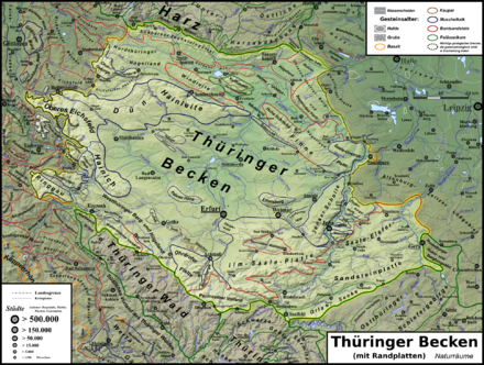
Thuringian Basin (with edge plates) denotes a natural spatial main unit group according to the manual of the natural spatial structure of Germany , which includes the flat , undulating Keuper landscape of the Thuringian Basin , its up to 604.4 m ( Reinsberge ) high edge plates made of shell limestone and partly their frame made of red sandstone and the Zechstein belt around adjacent low mountain range includes. The Keuperbecken is almost entirely in Thuringia, its edge plates are also partly in Saxony-Anhalt and Hesse , with a minimal proportion in Lower Saxony .
The structure of the manual was largely adopted by the Federal Agency for Nature Conservation (BfN). The Thuringian State Institute for Environment and Geology in Jena (TLUG) has created its own natural spatial structure, which contains many sub-units almost identical, but does not provide for hierarchies in main unit groups and main units, but only classified according to the rocks in question, whereby both island-like units occur as also those that are divided into several parts by other units. In contrast, in the manual, all natural spatial units are simply connected (i.e. without "holes" and without interruptions) , which is why geologically deviating sub -natural areas were integrated into a coherence if necessary.
Natural structure
The Thuringian Basin (with edge plates) represents the only natural spatial main unit group which, due to its size, has received two two-digit indicators. In the following breakdown into main units (three digits) and, if applicable, sub-units according to TLUG Jena, the size, the location within the unit, the federal states involved ( TH , ST , HE or NI ) as well as the rock ( Rotliegend , Zechstein , Buntsandstein ) are given in brackets , Muschelkalk , Keuper ; Flussaue ) stated:
-
47/48 Thuringian Basin (with edge plates) - 9,909 km²
- 470 Orlasenke (137 km²; extreme southeast, TH; Zechstein)
- 471 Saale-Elster sandstone slab (916 km²; southeast, TH / ST ; red sandstone)
- (TLUG calls the inner-Thuringian part of the Saale sandstone slab )
- 472 Middle Saale Valley (151 km²; southeast, TH; Saale floodplain )
- 473 Paulinzellaer Vorland (202 km²; extreme south, TH; red sandstone)
- 474 Ilm-Saale- and Ohrdrufer Platte (1399 km²; south-east of the core basin, TH; Muschelkalk)
- Tannrodaer Waldland (island-like central; red sandstone)
- Left slopes of the Saale between Rudolstadt and Kahla (south, red sandstone; at TLUG to the Saale sandstone slab )
- 480 Waltershausen foothills (93 km²; extreme southwest, TH; red sandstone)
- 481 West Thuringian mountain and hill country (495 km²; south-west of the core basin, TH; Keuper)
- Hörselberge and western edge of Eisenach - Krauthausen - Creuzburg - Mihla (part of the TLUG unit Werrabergland-Hörselberge ; Muschelkalk)
- 482 Thuringian Basin (2528 km²; central, TH / ST ; Keuper)
- Fahnersche Höhe (island-like just southwest of the center, TH; Muschelkalk)
- Ettersberg (island-like southeast of the center, TH; Muschelkalk)
- Unstrutaue Mühlhausen - Bad Langensalza (northwest, river floodplain of the Unstrut )
- 483 Ringgau – Hainich – Obereichsfeld – Dün – Hainleite (1360 km²; west to north of the core basin, TH / HE; Muschelkalk)
- 484 Northern Thuringian hill country (498 km²; north, TH; red sandstone)
- (In the North Thuringian red sandstone region, TLUG combines the hill country on the one hand with the lower Eichsfeld adjoining to the west, exclusive of the island-like Muschelkalk mountain range Ohmgebirge - Bleicheröder mountains and the small Thuringian part of the Leine-Ilme-Senke , on the other hand in the east with the northwesternmost Part of the Lower Unstrut mountain and hill country , which extends to Nordhausen ; in the eastern part this corresponds to the landscape profiles of the BfN, which let the northern Unstrut mountain and hill country end at Berga to the west )
- 485 South Harz Zechstein belt (267 km²; extreme north, TH / NI ; Zechstein)
- 486 Kyffhäuser Mountains (72 km²; North, TH / ST ; Rotliegend )
- Zechstein belt at Kyffhäuser (southern part of the unit; Zechstein)
- 487 Gera-Unstrut-Helme-Niederung (528 km²; from the southern center of the core basin to the north, TH / ST; floodplain of Gera , Unstrut and Helme )
- Gera-Unstrut lowland (inside the core basin, TH)
- Helme-Unstrut-Niederung (north of the core basin, TH / ST)
- Eastern roofing of the Kyffhäuser (central, TH / ST; Buntsandstein - at TLUG part of the Hohe Schrecke – Schmücke – Finne unit )
- 488 Unteres Unstrut mountain and hill country (853 km²; northeast to the extreme eastern north, ST / TH; red sandstone)
- Hohe Schrecke - Schmücke - Finne (in BfN profile southern Unstrut mountain and hill country , southeastern part, ST / TH; at the southwestern seam limestone, otherwise red sandstone)
- 489 Querfurter Platte and Untere Unstrut Platte (446 km²; extreme northeast to northern east, ST; shell limestone)
Adjacent main unit groups and main units
The edge plates of the Thuringian Basin meet, clockwise, in the south and southwest on the Thuringian-Franconian low mountain range with the Thuringian Slate Mountains and the Thuringian Forest , to the west on the East Hessian mountainous region with the Fulda-Werra mountainous region and the Lower Werrabergland , to the northwest the Lower Saxon hill country with (v. a.) Unterem Eichsfeld and Eichsfeld basin , to the north on the Harz , to the north-east on the Central German black earth region with the eastern Harz foreland , to the east on the Saxon hill country with the Altenburg-Zeitzer loess hill country and to the south-east on the Vogtland with the East Thuringian-Vogtland plateaus .
Geological structure and geomorphology

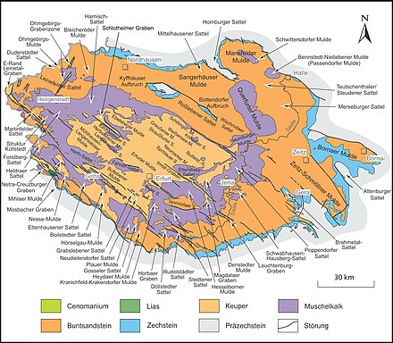
The Thuringian Basin and its framing form a semi-concentric layered landscape of the Triassic . The hilly, agriculturally productive Keuper - Hill Country is of mighty limestone enclosed -Höhenzügen that her rather gradually rise as a rule from the pool inside, but often on the outer edge in a steep escarpment fall.
This is particularly clear in the western Dün , to which, from the Unstrut near Dachrieden (approx. 240 m ), the landscape rises over 14 km to the northwest to a good 515 m to the Hockelrain (an average of 2% = 1 ° slope), in order to descend very abruptly on its northern slope within a good 300 horizontal meters from 500 m to 400 m (average 30% = 17 ° slope, in places over 100% = 45 °), until then in the red sandstone the terrain again gradually to about 310 m falls off the leash at Beuren .
The stratified ribs of the Hörselberge show similar relationships between the slopes with an overall steeper course . So falls from pointing into the bowl interior northeast slope of Great Hörselbergs 484 m from the landscape within about 850 horizontal meters the altitude of 475 m to 375 m (average of 12% = 7 ° slope), while the same difference in height at the outwardly facing southwest side within a few than 150 horizontal meters (on average 70% = 35 ° slope!) is mastered.
The more impressive, in absolute terms, rapid decline to the outside is shown by Gobert at the Hohestein 569 m high in the west, on the state border with Hesse, on the western flank of which the landscape is within 1.4 kilometers of the Hörne (approx. 515 m ) by 365 meters drops to 150 m on the Werra (average 26% = 15 ° gradient). However, the Gobert is separated from the eastern ridge of the Upper Eichsfeld framing the Keuperbecken by a depression along the Eichenberg – Gotha – Saalfelder fault zone and is mostly counted as part of the neighboring main unit Lower Werrabergland (main unit group Osthessisches Bergland ).
In contrast, the basin in the east, in the area of the Finne fault zone , is limited in places by a shell limestone ridge that is steep on both sides, but less high overall, while in the southeast the ascent to the Ilm-Saale plate is inconspicuous. In a small bay in the western south, between Ohrdruf and Georgenthal , the layers of shell limestone and red sandstone are almost completely omitted, and the basement of the Thuringian Forest , which can be reached very quickly by 700 m and more, rises up immediately.
The red sandstone heights adjoining the shell limestone to the outside , unlike this z. B. on the southwest flank of the Thuringian Forest (ie from the Keuperhügelland of the Grabfeld to the outside ) is the case, mostly not the height of their shell limestone neighbors. And where they protrude above the shell limestone (e.g. Finn in the northeast) or almost reach its heights ( wind deflector in the north), they rise significantly more gently than the layer level falls.
External elevation profile
The immediate edge heights of the central Keuper basin, i.e. the actual Thuringian Basin and the inner West Thuringian mountain and hill country , show the following heights above sea level, clockwise, starting at the Ilmau exit in the extreme east. NHN on:
(at edge heights from 1 km distance the approximate distance to the pool edge is given, elevations in the 2nd row are indented;
if there is no shell limestone on the edge heights , the corresponding rock is given)
-
Ilm-Saale- and Ohrdrufer plate
- Silberhügel ( 261 m , Ilm-Saale-Platte immediately to the right of the Ilm)
-
Hainicher Berg ( 339 m , 7 km; north of the Ilm-Saale-Platte, near the Ilm outlet)
- Kaitsch ( 497.4 m , 10 km; Ilm-Saale-Platte)
- ↓ Ilm entry near Weimar (approx. 200 m )
-
Berg an der Wasserleite ( 491 m , 2 km; Reinsberge / Ohrdrufer Platte immediately to the right of the Gera entrance)
- Halskappe ( 605.4 m , 9 km; Reinsberge / Ohrdrufer Platte not far to the right of the Gera)
- ↓ Gera entry at Arnstadt (approx. 280 m )
-
Maempels view ( 438 m , 1.5 km; plateau of Gossel / Ohrdrufer Platte immediately to the left of the Gera entrance)
- Ebanotte ( 517.8 m , 5 km; plateau of Gossel / Ohrdrufer Platte not far to the left of the Gera)
- ↓ Wilde Weisse entry in the west of Arnstadt (approx. 280 m )
- Pfennigsberg ( 431 m , northeast of the western Ohrdrufer Platte , immediately west of the Wilde-Weisse entrance)
- Wachsenburg ( 421 m , Drei Gleichen / West Thuringian mountain and hill country)
- Schloßleite ( 400 m , Drei Gleichen / West Thuringian mountain and hill country)
- Musketierberg ( 461 m , 1.5 km; northwest of the Ohrdrufer Platte)
-
Thuringian Forest ( Basement Mountains )
- Kienberg ( 720.3 m , 1 km)
- ↓ Ohra entry between Ohrdruf and Luisenthal (approx. 410 m )
-
Brandkopf ( 672 m , 1.5 km)
- Großer Buchenberg ( 812.7 m , 8 km)
- ↓ Apfelstädt entry at Georgenthal (approx. 380 m )
-
Waltershäuser Vorberge ( red sandstone )
- Ziegelberg ( 519 m , 1 km)
- ↓ Hörsel entrance at Schönau vor dem Walde (approx. 315 m )
-
Finstere Tanne ( 520 m , 1.5 km)
- Großer Inselsberg ( 916.5 m , 8 km; Thuringian Forest)
- Western edge of the West Thuringian mountain and hill country
- ↓ Hörsel exit at Sättelstädt (approx. 265 m )
- Hörselberge ( 484.2 m )
- Petersberg ( 344 m )
- ↓ Nesse estuary in Eisenach ( 215 m )
- Karlskuppe ( 377 m )
- Moseberg ( 364 m )
- ↓ Madel exit at Madelungen (approx. 240 m )
- Hohleite ( 385.8 m )
- Mihlberg ( 378 m )
- ↓ Lauterbach - confluence with the Werra near Mihla ( 184 m )
-
Ringgau – Hainich – Obereichsfeld – Dün – Hainleite
- Harsberg ( 410 m ; southwest edge of the Hainich near the mouth of the Lauterbach)
- Old Mountain ( 493.9 m , 2 km; Hainich )
- Rain northwest of Struth ( 516.7 m , 5 km; Upper Eichsfeld )
- ↓ Unstrut entry at Dachrieden (approx. 240 m )
- Kuppe near the Keulaer Rondell ( 522 m , 11 km; Dün )
- ↓ Helbe entry at Wiedermuth (approx. 250 m )
- Kuppe southwest of Straussberg ( 463.2 m , 7 km, western Hainleite )
- Wolfshof ( 442 m , middle Hainleite southeast of Sondershausen )
- ↓ Wipper entry at Günserode (approx. 150 m )
- nameless summit ( 391 m , 1 km; eastern Hainleite, immediately to the left of the Wipper)
-
Gera-Unstrut-Helme-Niederung (flood plain)
- ↓ Unstrut exit ( Thuringian Gate ) between Sachsenburg and Oldisleben (approx. 125 m )
-
Lower Unstrut mountain and hill country (red sandstone with a ridge made of shell limestone)
- Scharfer Berg ( 250 m , northwestern spur of the Schmücke in the immediate vicinity of the gate)
- Künzelsberg ( 380.1 m , 1 km; Schmücke )
- ↓ Hirschbach entry at Burgwend (approx. 230 m )
-
Finnberg ( 330 m , western ridge of the Finns)
- Steinberg ( 359 m , red sandstone ; plateau of the northwestern Finn )
- ↓ Lossa entry at Rastenberg (approx. 200 m )
- Mühlberg ( 312 m , 1 km, red sandstone; southeastern Finn)
- Klosterholz ( 312 m , 1 km, red sandstone; southeastern Finn)
-
Querfurter plate and Untere Unstrut plates
- Schlossberg Eckartsberga ( 300 m )
- Sonnenkuppe ( 236 m , immediately to the left of the Ilm Valley)
- [↓ again Ilm exit at Bad Sulza (approx. 115 m - near the confluence with the Saale )]
Disturbances and clods
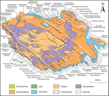
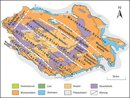
The area of the Thuringian Basin and its edge plates is mainly hercynian , i.e. H. Geological faults (↓) running from north-west to south-east divided into ground clods (→).
From northeast to southwest follow one another (landscapes outside the main unit group in lower case) :
- → Merseburg plaice
- South Harz Zechstein belt north of Nordhausen , northern Lower Unstrut mountain and hill country near Sangerhausen and Helme-Unstrut lowland near Artern
- Eastern Harz foreland west of Halle and Querfurter Platte near Querfurt
- → Meuselwitzer Scholle :
western Leipzig country west of Leipzig and Altenburg – Zeitzer loess hill country between Weißenfels and Altenburg
- ↓ Kyffhäuser – Crimmitschauer fault zone
- → Hermundurian plaice
- Kyffhäuser , Windleite
- High horror , jewelry
- fin
- Lower Unstrut plates southwest of Naumburg
- Southwestern Altenburg-Zeitz loess hill country south and south-east of Naumburg
- extreme north of the Saale-Elster sandstone plate northwest of Geras
- ↓ Fin fault zone
- ↓ Finn disorder (between Sondershausen and Thüringer Pforte only weak flexure , from there to Bad Sulza N partly striking northeast boundary of the Thuringian basin)
- ↓ Frauenprießnitzer disorders in Frauenprießnitz
- ↓ Eisenberger disturbance at Eisenberg
- ↓ Pohlen fault south of Geras
- → Bleicherode – Stadtrodaer Scholle
- → Bleicherode – Sömmerdaer Scholle
- Bleicheröder Mountains near Bleicherode together with the southern roof in the Lower Eichsfeld
- Thin (without vests) and Hainleite
- northeastern Thuringian Basin around Sömmerda
- Ettersberg
- ↓ Apolda fault zone from Apolda to the south-south-west
- → Jenaer Scholle (northern part of the Ilm-Saale-Platte around Jena , at Wöllmisse , Horseshoe and Tautenburger Wald also to the right of the Saale)
- ↓ Stadtroda fault zone near Stadtroda
- → Münchenbernsdorfer Scholle (northeast part of the Saale-Elster sandstone slab near Münchenbernsfeld )
- → Bleicherode – Sömmerdaer Scholle
- ↓ Schlotheim – Leuchtenburg fault zone
- ↓ Schlotheimer Graben and Heilinger Heights
- ↓ Ilmtal ditch near Weimar
- ↓ Magdalaer Graben near Magdala
- ↓ Leutra fault zone near Leutra
- ↓ Leuchtenburg-Graben (offset to the south, on both sides of the Saale near Kahla )
- → Mühlhausen – Orlamünder Scholle
- West of the Dün, eastern half of the Upper Eichsfeld , Hainich
- Thuringian basin around Mühlhausen
- Ettersberg
- Thuringian Basin around Erfurt
- central Ilm-Saale-Platte together with the embedded Tannrodaer woodland near Tannroda
- southwestern Saale-Elster sandstone slab near Saalfeld
- Orlasenke near Pößneck
- ↓ Eichenberg – Gotha – Saalfelder fault zone
(within the Keuperbeckens along Krahnberg , Seebergen and Drei Gleichen ) - → Treffurt – Plauer Scholle
- Lower Werrabergland from Witzenhausen upstream to Treffurt , Northern Ringgau
- West of the Upper Eichsfeld, western roofing of the Hainich
- West Thuringian mountain and hill country north of Eisenach and south of Gotha together with Hörselbergen
- Waltershausen foothills near Waltershausen
- Ohrdrufer Platte east of Ohrdruf and Reinsbergen
- Paulinzellaer Vorland near Paulinzella
There are also:
- the northwest of the Upper Eichsfeld southwest of Heiligenstadt on the Eichsfeld plaice (northwest of the aforementioned plaice)
- the southern Ringgau on the Ringgau floe left of the Werra (west of the aforementioned floes)
Individual evidence
- ^ A b c d e E. Meynen and J. Schmithüsen : Handbook of the natural spatial structure of Germany (6th delivery 1959) - Federal Institute for Regional Studies, Remagen / Bad Godesberg 1953–1962 (9 deliveries in 8 books, updated map 1: 1,000. 000 with main units 1960)
- ↑ a b c d Map services of the Federal Agency for Nature Conservation ( information )
-
^ A b Walter Hiekel, Frank Fritzlar, Andreas Nöllert and Werner Westhus: The natural spaces of Thuringia . Ed .: Thuringian State Institute for Environment and Geology (TLUG), Thuringian Ministry for Agriculture, Nature Conservation and Environment . 2004, ISSN 0863-2448 . → Natural area map of Thuringia (TLUG) - PDF; 260 kB → Maps by district (TLUG)
- ↑ Hydrogeological map of Thuringia from the Thuringian State Institute for Environment and Geology (PDF; 4.37 MB) ( Even finer maps are available for each district .)
- ↑ designation according to manual; according to TLUG: Saale floodplain
- ↑ Designation according to the manual and BfN; according to TLUG: Paulinzellaer red sandstone woodland
- ↑ Designation according to the manual and BfN; according to TLUG: Ilm-Saale-Ohrdrufer Platte
- ↑ Designation according to TLUG and BfN; Original name according to the manual: Waltershausener Vorberge
- ↑ designation according to manual; according to TLUG: Zechstein belt on the southern Harz
- ↑ designation according to BfN; according to the manual: Helme-Unstrut-Niederung , which is misleading, as TLUG aptly uses this designation only for the northern part, which is outside the core basin; in the southern interior of the basin, the lowland follows the Gera .
- ↑ Designation according to the manual; Designation according to BfN: Eastern Harz foreland and Börden
- ↑ complete designation according to the manual: Saxon Hügelland (including Leipziger Land) ; according to BfN as Saxon hill country and Erzgebirgsvorland merged with another main unit group
- ↑ Name after the Saxon Academy of Sciences in Leipzig (SAW), cf. Natural areas in Saxony ; Manual: Altenburg-Zeitzer loess area
- ^ Regional geology East , Dietrich Franke


