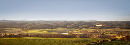
Oral cavity
The Orlasenke is an approximately 150 km² flat region in East Thuringia , which is traversed by the Orla in the eastern and central part and by its tributary Kotschau in the western part . In the times of German settlement (9th – 13th centuries) east of the Saale, Elster and Elbe, i.e. in the land of the Slavs, the settlement associations of the Sorbian tribes in the open landscapes were referred to as Gaue and this term was later also used for territories. This is why this area is also known as Orlagau .
geography
location
The orlas depression is about 35 kilometers long and up to five kilometers wide. The oral cavity begins at Triptis in the east and ends at Saalfeld in the west. It lies at an altitude of 200 to 300 meters and consists of very fertile soils, which enable diverse arable farming here. Parallel to the Orlasenke rise in the north the Vordere Heide and the Thuringian Holzland with up to 450 meters high elevations and in the south the Thuringian Slate Mountains with mountains up to 530 meters high.
Waters
The Orlasenke is not a continuous valley, but rather a watershed between Saalfeld and Pößneck. The Orla , coming from the direction of Triptis, changes the direction of flow to the northwest through the red sandstone area to the Saale shortly before Pößneck. While the Kotschau therefore drains east to the Orla, the Weira flows west to the Saale. Due to the karst phenomena in the depression, some smaller streams seep away from the slate mountains. On the northern edge there are some sinkholes filled with water, and numerous fish ponds and smaller irrigation reservoirs have been created.
Natural allocation
Geographically, it is within the main unit group Thuringian basin (with edge plates) at its southeastern edge, the main unit 470. In the innerthüringischen division deviating from the manual, the natural areas of Thuringia the Thuringian State Institute for Environment and Geology (TLUG) the unit is Orlasenke indicated km² 137 .
geology
The Orlasenke is a wide band from Zechstein . The sandstone area north of the depression was leached and removed here. There are numerous sinkholes at its northern transition to the red sandstone of the Saale-Elster-Platte . On the southern edge more resistant layers form of dolomite and limestone rock steeper sections (z. B. in Döbritz and on Totenstein ), called reefs , where castles were built ( Burg Ranis , Schloss Brandenstein , castle Könitz). There are also some caves here (Ilsenhöhle, Kniegrotte).
Traffic and settlement
The main arteries of the Orlasenke are the B 281 and the Gera – Saalfeld railway line , which both connect Gera in the east with Saalfeld in the west. The two largest cities in the Orlasenke are Pößneck (about 13,000 inhabitants) and Neustadt an der Orla (about 9,000 inhabitants). Other larger towns are (from east to west): Triptis , Oppurg , Krölpa , Kamsdorf and Unterwellenborn .
Between the construction of the railway line (1871) and German reunification (1990), the Orlasenke, with the city of Pößneck as its center, was a center of the textile industry in Thuringia.
Individual evidence
- ^ E. Meynen and J. Schmithüsen : Handbook of the natural spatial structure of Germany - Federal Institute for Regional Studies, Remagen / Bad Godesberg 1953–1962 (9 deliveries in 8 books, updated map 1: 1,000,000 with main units 1960)
- ^ Walter Hiekel: The Thuringian Slate Mountains and its northern foreland. VEB Hermann Haack Gotha, 1989, ISBN 3-7301-0104-8
literature
- Eds. Martin Heinze, Haik Thomas Porada, Marek Wejwoda: The Orlatal and the Plothener pond area. Vol. 76 of the series Landscapes in Germany, Verlag Böhlau Cologne 2017, ISBN 978-3-412-20748-9
Web links
- Tourism and economic information for the Orlasenke region ( Memento from April 3, 2007 in the Internet Archive )
- BfN landscape profile
Coordinates: 50 ° 43 ′ 6.6 " N , 11 ° 41 ′ 36.6" E

